A Quantitative Reconstruction Method of Paleowind Intensity Based on Remote Sensing Technology

A technology of ancient wind intensity and remote sensing technology, which is applied in the field of quantitative reconstruction of ancient wind intensity based on remote sensing technology to achieve the effects of reducing human error and reliable accuracy evaluation.

Active Publication Date: 2018-09-21
INST OF REMOTE SENSING & DIGITAL EARTH CHINESE ACADEMY OF SCI
View PDF4 Cites 0 Cited by
  • Summary
  • Abstract
  • Description
  • Claims
  • Application Information

AI Technical Summary

Problems solved by technology

[0004] However, there is no research in the field of applying remote sensing technology to the field of paleowind reconstruction in the prior art, and this application is based on this research

Method used


Image

  • A Quantitative Reconstruction Method of Paleowind Intensity Based on Remote Sensing Technology
  • A Quantitative Reconstruction Method of Paleowind Intensity Based on Remote Sensing Technology
  • A Quantitative Reconstruction Method of Paleowind Intensity Based on Remote Sensing Technology

Examples


Embodiment Construction

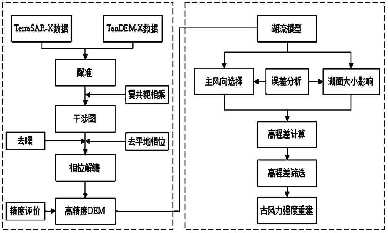
[0033] The present invention applies remote sensing technology to the quantitative reconstruction of paleowind intensity for the first time. The reconstruction method is to establish a lake flow model on the basis of the first generated high-precision DEM, and then through error analysis, elevation difference calculation and screening, and finally complete the paleowind intensity. Quantitative reconstruction of wind intensity.

[0034] Refer to attached figure 1 As shown, the specific technical process of the quantitative reconstruction method of paleowind intensity based on remote sensing technology in the present invention includes the following steps:

[0035] The first step is to obtain the TerraSAR-X / TanDEM-X long-baseline interference pair data in the study area. According to the introduction of the background technology of this application, the TerraSAR-X satellite and the TanDEM-X satellite launched by the German Space Agency fly in formation to build a dual-station S...


PUM


Abstract

The invention discloses a remote sensing technology based ancient wind strength quantification reconstruction method. The method comprises the step of A, generating a high-precision DEM and establishing a lake current model; and B, performing error analysis by utilizing the lake current model established in the step A, calculating elevation differences between upwind directions and downwind directions of main wind directions corresponding to different shrinkage traces in the generated DEM, representing main wind strength by the elevation differences, and screening elevation difference dispersion points obtained by calculation to complete the quantification reconstruction of ancient wind strength. According to the method, for a dry lake basin with clear shrinkage traces under the influence of wind in one main wind direction, by applying TDX / TSX long baseline interference pair data for the first time, the meter-scale elevation-precision DEM is generated, the lake current model is established, and the error analysis and the elevation difference calculation and screening are carried out to finally complete the quantification reconstruction of ancient wind strength, so that early complicated analysis in aspects of general atmospheric circulation and ancient climate is avoided, manual errors are reduced, and remote sensing technology based ancient wind strength reconstruction is realized in a breakthrough way.

Description

technical field [0001] The invention relates to the technical field of paleowind reconstruction, in particular to a method for quantitative reconstruction of paleowind intensity based on remote sensing technology. Background technique [0002] Global climate change is a hot spot in scientific research today, and the recovery of paleoclimate and paleoenvironmental change data is the basis for studying future climate and environmental evolution. Atmospheric circulation is one of the important factors controlling climate, and the restoration of paleoatmospheric circulation patterns plays a vital role in understanding the characteristics and evolution of paleoclimate. Paleowind force is an important content of paleoatmospheric circulation and a direct record of paleoatmospheric circulation. Its reconstruction can clearly describe the pattern of paleoatmospheric circulation. [0003] In the field of remote sensing, breakthroughs have been made in spaceborne SAR technology and ap...

Claims


Application Information

Patent Timeline
Patent Type & Authority Patents(China)
IPC IPC(8): G06F17/50G06T7/30
CPCG16Z99/00
Inventor 谢凯鑫宫华泽王龙飞邵芸刘长安李冰艳
Owner INST OF REMOTE SENSING & DIGITAL EARTH CHINESE ACADEMY OF SCI
Why Eureka
Try Eureka