A calculation method of vegetation index against atmospheric aerosols
An atmospheric aerosol and vegetation index technology, which is applied to measuring devices, material analysis through optical means, instruments, etc., can solve the problem of model errors that cannot be corrected for images to be corrected, and achieve the effect of avoiding model errors
- Summary
- Abstract
- Description
- Claims
- Application Information
AI Technical Summary
Problems solved by technology
Method used
Image

Examples
Embodiment 1
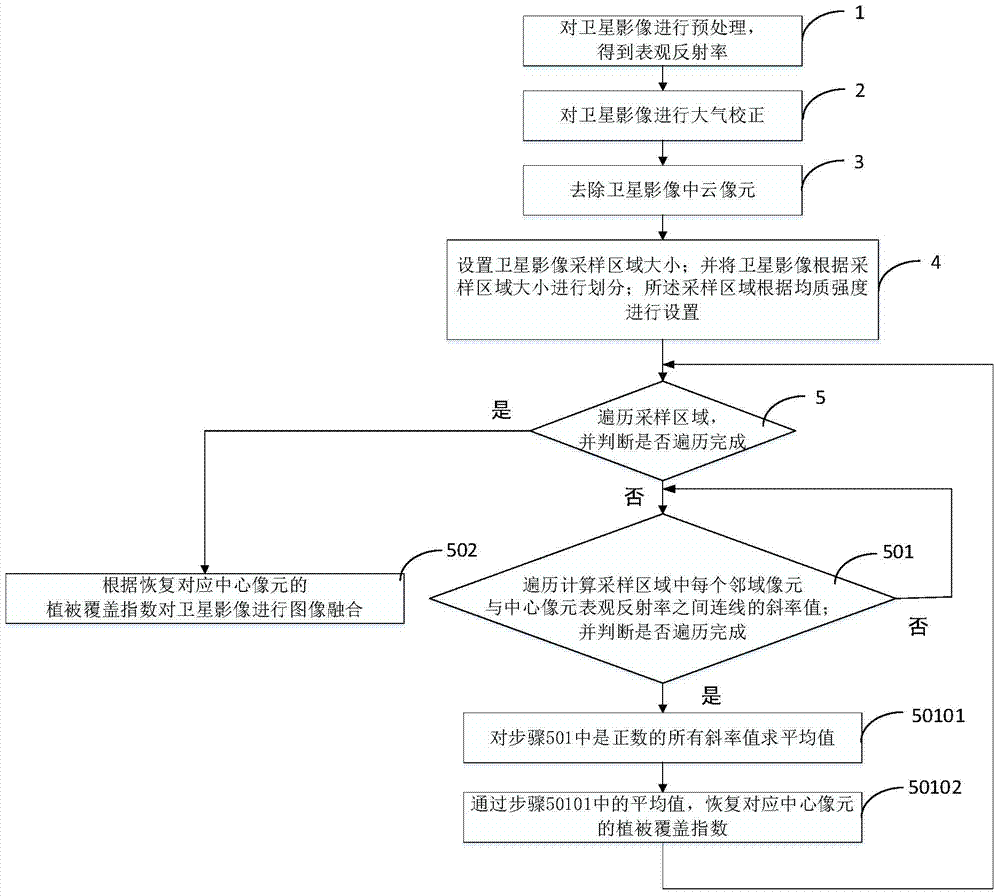
[0039] Such as figure 1 Shown, anti-atmospheric aerosol vegetation index calculation method of the present invention, comprises the following steps;
[0040] Step 1: Preprocess the satellite image to obtain the apparent reflectance;
[0041] Step 2: Atmospheric correction of satellite images;
[0042] Step 3: Remove cloud pixels in satellite images;
[0043]Step 4: Set the size of the satellite image sampling area; and divide the satellite image according to the size of the sampling area; the sampling area is set according to the homogeneous intensity;
[0044] Step 5: Traversing the sampling area, and judging whether the traversal is complete;
[0045] If the traversal is not completed, then execute step 501;
[0046] If the traversal is complete, then execute step 502;
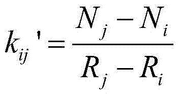
[0047] Step 501: traverse and calculate the slope value of the line between each neighborhood pixel and the apparent reflectance of the central pixel in the sampling area; and judge whether the traverse...
Embodiment 2
[0065] The following is a verification of the invention using simulated data.
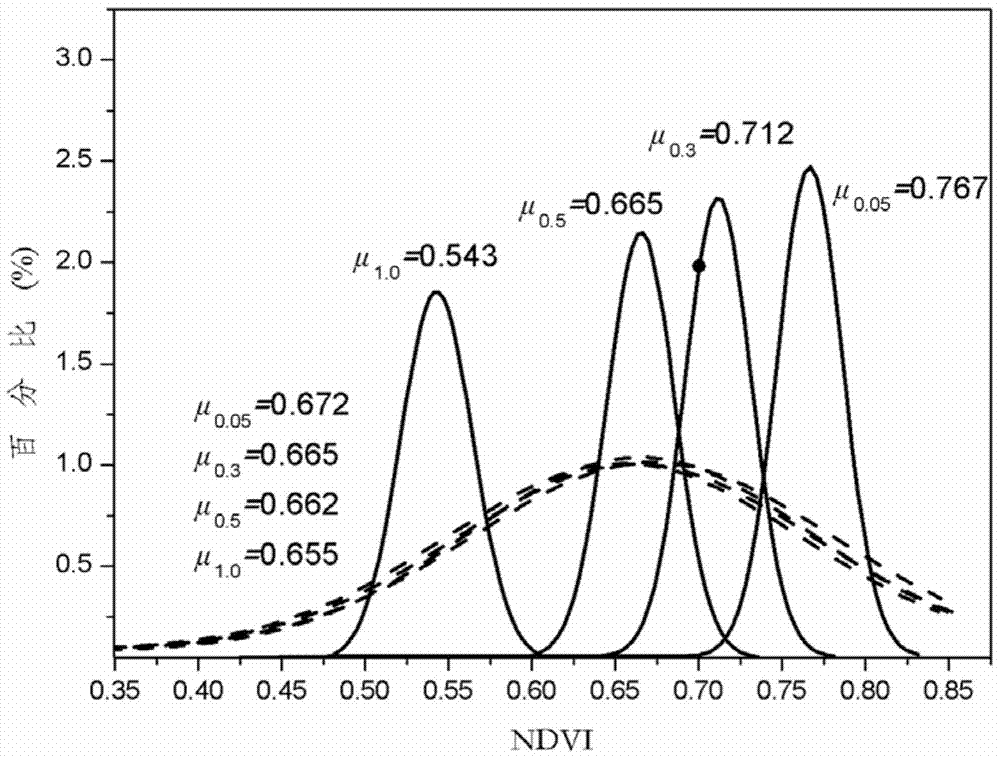
[0066] Such as figure 2 , which is a comparison chart of the NDVI obtained by correcting the satellite image and the apparent NDVI with the change of the aerosol concentration by using the method of the present invention. The specific experimental parameters used are as follows: Using the Landsat8 real surface reflectance product provided by ESPA at 11 am on August 19, 2014 in Tianjin, China, using the 6S atmospheric correction model surface real reflectance image at AOD=0.05, AOD=0.3, AOD =0.5 and the corresponding apparent reflectance in the case of AOD=1.0.
[0067] pass figure 2 It can be seen that the aerosol has a great influence on the apparent reflectance, so the apparent NDVI cannot truly reflect the vegetation coverage on the surface. The invention well eliminates the influence of the aerosol on the NDVI, and realizes the effect of quickly evaluating the vegetation coverage change on...
Embodiment 3
[0069] Table 1
[0070]
[0071] Form 2
[0072]
[0073] As shown in Table 1 and Table 2, Table 1 is the accuracy verification result of aerosol correction using the method of the present invention in Yichun and Suihua areas, and Table 2 is the accuracy verification result of aerosol correction using the method of the present invention in Beijing area.
[0074] In the figure, "region" indicates the region of interest selected from the remote sensing image; "AE (absolute error)" indicates the absolute error; "size" indicates the number of pixels in the area of interest; "vegetation coverage" indicates the level of vegetation coverage ; "extent of correction" indicates the degree of aerosol correction (obtained from the second column / first column of the table).
[0075] The specific experimental parameters used are as follows: use the Lansat8OLI image and the corresponding time provided by ESPA at the junction of Yichun City and Suihua City, Heilongjiang Province, Chin...
PUM
 Abstract
Description
Claims
Application Information
 - R&D
- Intellectual Property
- Life Sciences
- Materials
- Tech Scout
- Unparalleled Data Quality
- Higher Quality Content
- 60% Fewer Hallucinations
Browse by: Latest US Patents, China's latest patents, Technical Efficacy Thesaurus, Application Domain, Technology Topic, Popular Technical Reports.
© 2025 PatSnap. All rights reserved.Legal|Privacy policy|Modern Slavery Act Transparency Statement|Sitemap|About US| Contact US: help@patsnap.com