
Plain area water system characteristic evaluation method based on ArcGIS (Geographic Information System)

A feature evaluation, water system technology, applied in the direction of instrument, data processing application, calculation, etc., can solve the problems of low index efficiency and need further theoretical analysis and practical verification.

Inactive Publication Date: 2015-11-11
徐光来
View PDF2 Cites 6 Cited by
  • Summary
  • Abstract
  • Description
  • Claims
  • Application Information

AI Technical Summary

Problems solved by technology

However, plain water systems are very different from natural water systems (such as dendritic water systems) due to their geomorphological characteristics and formation reasons. Borrowing natural water system structure indicators can quantify the characteristics of water system structures in plain areas to a certain extent, but further research is needed for widespread use. Theoretical analysis and practical verification
[0005] Ineffective duplication of metrics

Method used


Image

  • Plain area water system characteristic evaluation method based on ArcGIS (Geographic Information System)
  • Plain area water system characteristic evaluation method based on ArcGIS (Geographic Information System)
  • Plain area water system characteristic evaluation method based on ArcGIS (Geographic Information System)

Examples


Embodiment 1

[0039] An ArcGIS-based evaluation method for water system characteristics in plain areas, the steps are:

[0040] (A) Acquisition of river network data in the study area

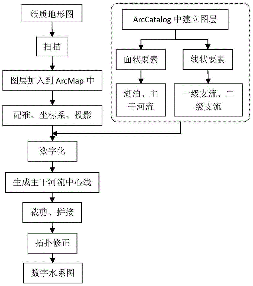
[0041] A1, scanning and registration. The 1:50,000 topographic map of the study area was scanned with an accuracy greater than 300dpi. Load the scanned map in ArcMap, set the layer display to degrees (DegreesDecimalMinutes), register according to the coordinates on the topographic map, and export (rectify) it into a tiff map. Set the coordinate system and projection of the map in ArcCatalog. According to the location of the study area and the time when the topographic map was formed, the coordinate system is Beijing 1954, and the projection is Gauss-Krüger projection 6-degree zone 21 (Beijing1954GKZone21N.prj).

[0042] A2. Create layers. In ArcCatalog, establish two vector layers of linear features of primary tributaries (layer ①) and secondary tributaries (layer ②), and two surface features of main rive...

Embodiment 2

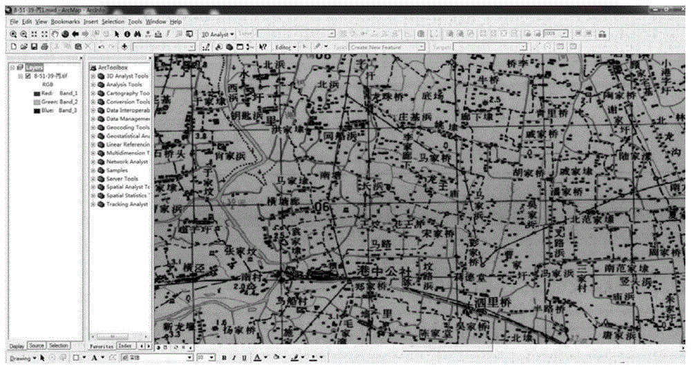
[0071] Taking the 1960s Fifty Thousand topographic map of the Hangjiahu area in the Taihu Lake Basin as an example, the Hangjiahu Plain is located in the south of the Taihu Lake Basin, with an area of ​​about 7607km 2 . The rivers in the area are criss-crossed, belonging to a typical plain area, with a river network density of 2.3km / km 2 , The water surface rate is about 8.6%. Scan and register the 1:50,000 paper topographic map of the Hangjiahu area in the 1960s (see image 3 topographic map of the study area), digitized (see Figure 4 digitization of topographic maps), topology inspection, splicing and cropping, etc., to obtain water system maps (see Figure 5 water system map of the study area). Table 1 is the classification of river systems and rivers in the plain river network area of ​​the present invention. Table 2 is the water system structure index parameter system of the present invention. The following table 1 is the water system classification in the plain ar...

Embodiment 3

[0077] The lack of digital topographic maps before 2000 is not conducive to the analysis of water system characteristics. The invention is based on the ArcGIS technology, adopts a simple method to extract the water system data of the topographic map, and is convenient for implementation and operation.

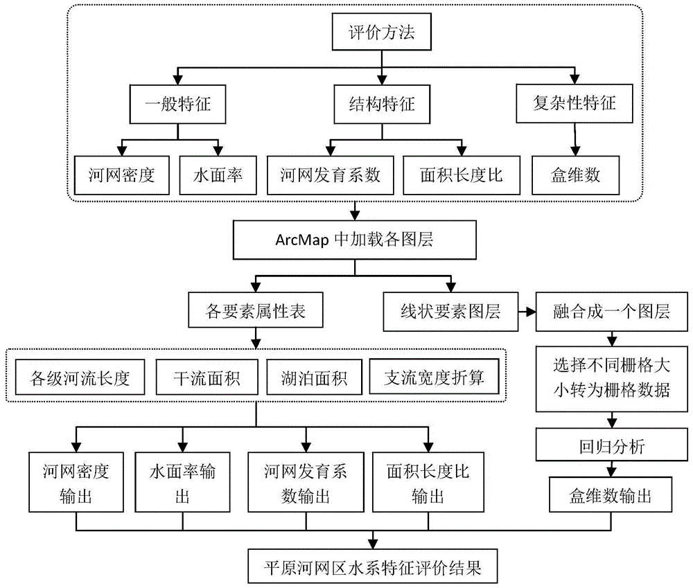
[0078] The present invention characterizes the water system characteristics of the plain river network area through 3 categories and 5 items of indicators, and the water system indicators are independent of each other. . Among them, the ratio of area to length is a new index of the present invention. Compared with the previous complicated and repeated indexes, the evaluation method of the present invention is more systematic and scientific. And the method is simple to operate and easy to promote to other regions. Table 3 shows the advantages of the index parameter system of the present invention.

[0079] table 3

[0080]

[0081]


PUM


Abstract

The invention relates to the technical field of the hydrographic engineering, in particular to a plain area water system characteristic evaluation method based on an ArcGIS (Geographic Information System). The plain area water system characteristic evaluation method comprises the following steps: 1) scanning a paper topographic map, and obtaining a picture with a geographic coordinate system and a projection; 2) carrying out water system classification on the picture obtained in the step 1), and independently digitizing each level of water system to obtain a digital plain river network map; 3) according to a water system structure characteristic index, endowing a water system characteristic parameter of the water system structure characteristic of the digital plain river network map; and 4) according to the digital plain river network map obtained in the step 2) and the water system characteristic parameter obtained in the step 3, carrying out comprehensive evaluation on the plain water system. The plain area water system characteristic evaluation method has the beneficial effects that the water system characteristics and the hydrographic characteristics of a plain river network are comprehensively and systematically expressed through five indexes. Compared with a traditional complex and repeated index, the evaluation method is more systematic and scientific.

Description

technical field [0001] The invention relates to the technical field of water conservancy engineering, in particular to an ArcGIS-based evaluation method for water system characteristics in plain areas. Background technique [0002] The development of plain water systems is strongly disturbed by human activities. The development of water systems has violated the development rules of natural water systems, and it is difficult to extract and classify water systems like natural water systems using DEM to automatically extract river networks, which makes it difficult to count the number and length of rivers in plain areas. conduct. [0003] Existing quantitative methods of water system structure in plain areas are diverse but lack of unity. The elevation difference in the plain river network area is small, and there is no obvious distinction between upstream and downstream. The water system is generally criss-crossed in a grid pattern, and the distribution and structure (or patt...

Claims


Application Information

Patent Timeline
IPC IPC(8): G06Q50/06
Inventor 徐光来
Owner 徐光来
Learn More