A joint positioning method and system based on bd2 and ground-based navigation system

A navigation system and joint positioning technology, applied in the field of navigation and positioning, can solve the problems such as the inability to realize the ranging path and the complex surface terrain, and achieve the effect of overcoming the limited navigation range, improving the positioning accuracy and strong reliability.

Active Publication Date: 2017-07-28
THE GENERAL DESIGNING INST OF HUBEI SPACE TECH ACAD
View PDF5 Cites 0 Cited by
  • Summary
  • Abstract
  • Description
  • Claims
  • Application Information

AI Technical Summary

Problems solved by technology

The system has the characteristics of simple construction, low cost, and high positioning accuracy; however, its disadvantage is that the surface terrain is complex, and the distance measurement channel may not be realized in some moments

Method used


Image

  • A joint positioning method and system based on bd2 and ground-based navigation system
  • A joint positioning method and system based on bd2 and ground-based navigation system
  • A joint positioning method and system based on bd2 and ground-based navigation system

Examples


Embodiment Construction

[0033] In order to make the object, technical solution and advantages of the present invention clearer, the present invention will be further described in detail below in conjunction with the accompanying drawings and embodiments. It should be understood that the specific embodiments described here are only used to explain the present invention, not to limit the present invention. In addition, the technical features involved in the various embodiments of the present invention described below can be combined with each other as long as they do not constitute a conflict with each other.

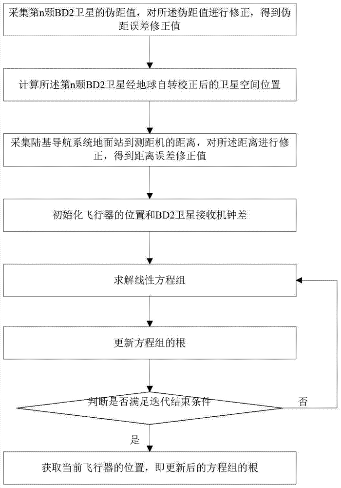
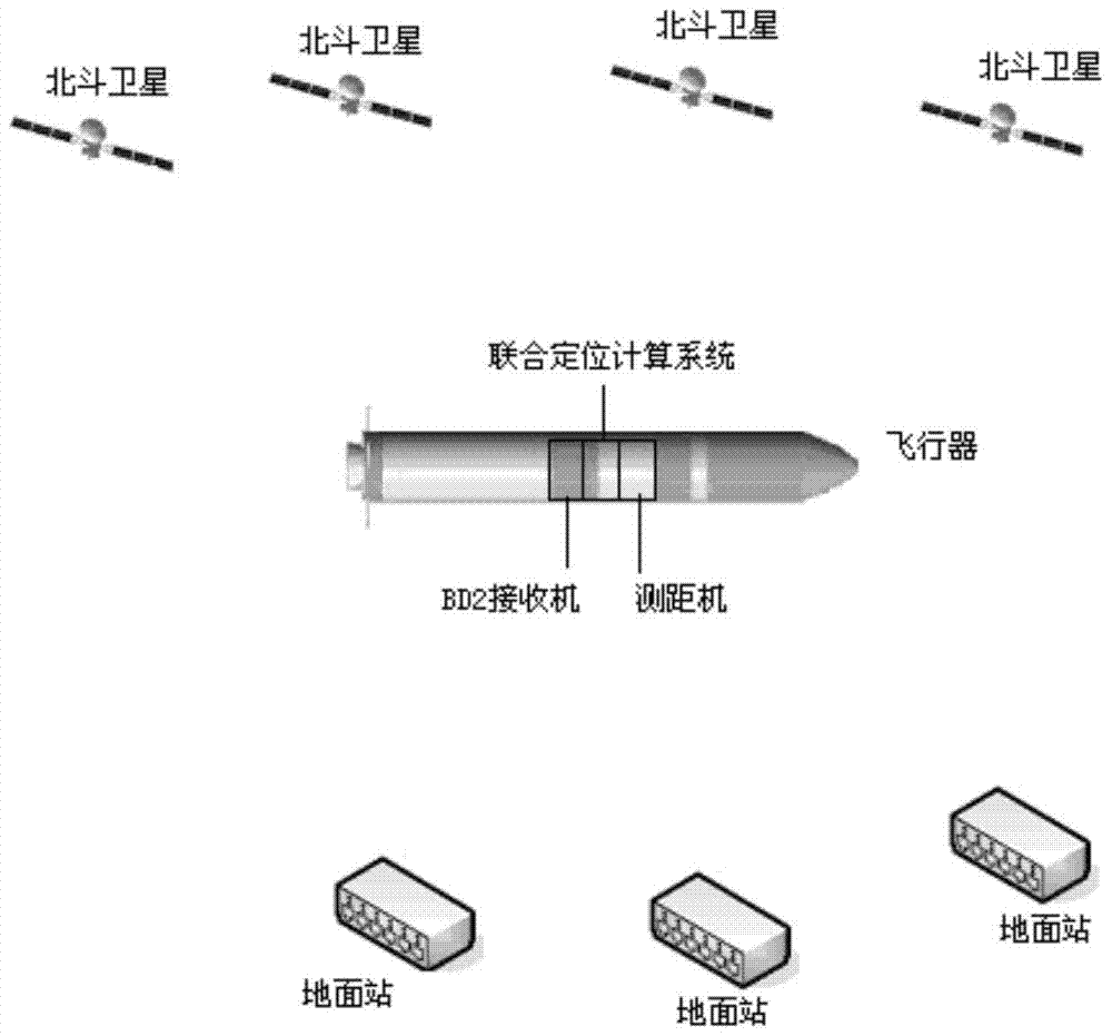
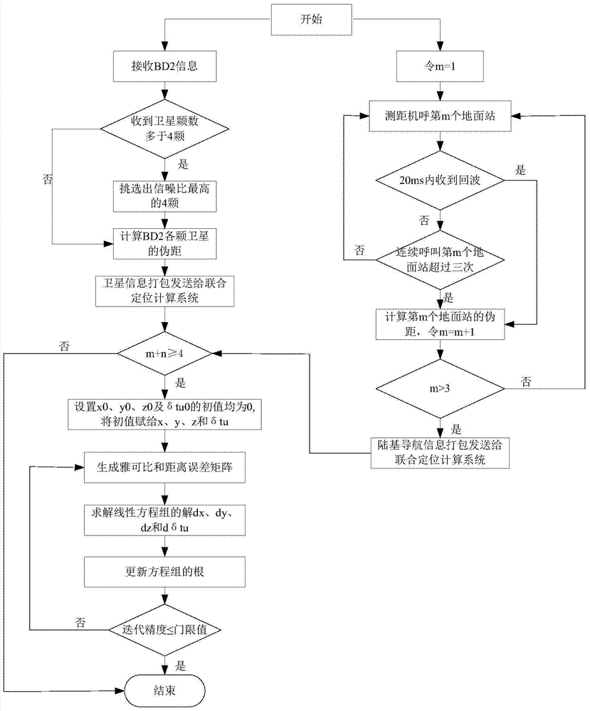
[0034] Such as figure 1 As shown, the present invention provides a kind of joint positioning method based on BD2 satellite and ground-based navigation system, and method comprises steps:

[0035] S1. Obtain the pseudorange ρ of the nth visible BD2 satellite (1n) . ρ (1n) is the error correction value, the correction formula is as follows:

[0036] ρ (1n) =D (1n) +δt u -I (1n) -T (1n) ...


PUM


Abstract

The invention discloses a combined positioning method and system based on BD2 and a ground-based navigation system, and the method comprises the steps: S1, collecting and correcting a pseudo-range value of a BD2 satellite; S2, calculating the spatial position of the BD2 satellite after earth rotation correction; S3, collecting and correcting the distance from a ground station of the ground-based navigation system to a distance measurement machine; S4, initializing the position of an aircraft and a clock error of a satellite receiver; S5, building and solving a corresponding linear equation group; S6, updating the roots of the linear equation group; S7, judging whether the iteration is ended or not: calculating an iteration threshold value delta, and enabling the calculation result obtained at step S6 to serve as the current position of the aircraft and enabling the iteration to be ended if the delta is not greater than a preset threshold value; or else, repeatedly carrying out step S5-S7 till the iteration is ended. The invention also provides a system achieving the above method. The method and system can greatly improving the positioning precision of a system, are not dependent on GPS resources, can be used during wartime, and are high in reliability.

Description

technical field [0001] The invention belongs to the technical field of navigation and positioning, and more specifically relates to a joint positioning method and system based on BD2 and a ground-based navigation system. Background technique [0002] In the past, when the aircraft was guided and positioned, GPS information was generally used for positioning. However, the GPS system is a national asset of the U.S. government and is managed by the Department of Defense. The United States reserves the right to limit the strength and accuracy of GPS signals, or completely shut down GPS services, so that the U.S. military and its allies can exclusively enjoy GPS services in times of conflict. [0003] Therefore, when countries develop their own aircraft, more and more countries consider positioning methods that do not rely on GPS information. As the coverage and positioning accuracy of the BD2 satellite navigation system are further enhanced, the BD2 satellite navigation system ...

Claims


Application Information

Patent Timeline
Patent Type & Authority Patents(China)
IPC IPC(8): G01S19/46
CPCG01S19/46
Inventor 李小丹杨道安彭克学白明顺高帆张晶邓潺周鄂炯
Owner THE GENERAL DESIGNING INST OF HUBEI SPACE TECH ACAD
Why Eureka
Try Eureka