A fast measurement method for high-precision vertical line deviation integrated with gnss and ccd zenith

A vertical line deviation and measurement method technology, applied in special data processing applications, instruments, electrical digital data processing, etc., can solve the problems that the baseline cannot be too long, cannot be obtained effectively, and the measurement is difficult, so as to meet the requirements of measurement accuracy and No geographical restrictions, high measurement accuracy and no geographical restrictions, the effect of reducing time consumption

Active Publication Date: 2017-08-25
SHANDONG UNIV OF SCI & TECH
View PDF3 Cites 0 Cited by
  • Summary
  • Abstract
  • Description
  • Claims
  • Application Information

AI Technical Summary

Problems solved by technology

However, the above-mentioned methods generally have shortcomings or deficiencies such as complex basic data collection process, or cannot be effectively obtained at all, cumbersome and complicated post-data processing process, time-consuming and labor-intensive, etc.:
[0012] However, there are limitations in the use of this method. For example, it is too difficult to carry out precise leveling in some areas with large terrain fluctuations, and the baseline cannot be too long. The accuracy of the vertical line deviation calculated by it is low

Method used


Image

  • A fast measurement method for high-precision vertical line deviation integrated with gnss and ccd zenith
  • A fast measurement method for high-precision vertical line deviation integrated with gnss and ccd zenith
  • A fast measurement method for high-precision vertical line deviation integrated with gnss and ccd zenith

Examples


Embodiment 1

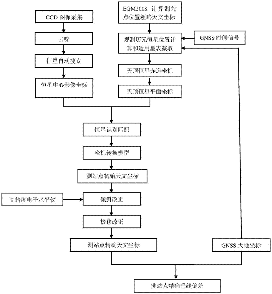
[0245] Taking a university campus as an example, the above-mentioned high-precision vertical line deviation rapid measurement method integrated with GNSS and CCD zenith tube is used to quickly measure the vertical line deviation of the university campus.

[0246] The specific measurement process is as follows:

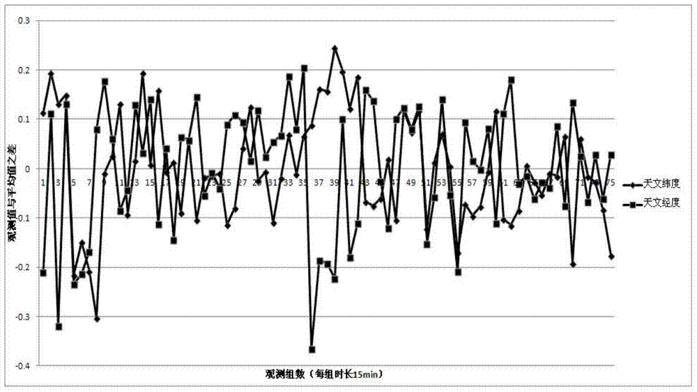
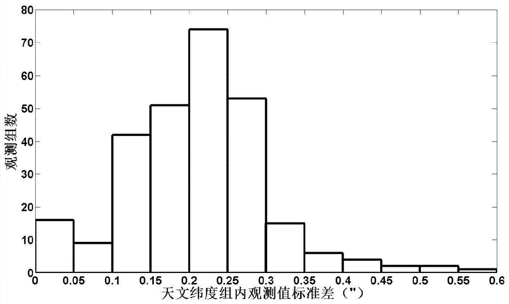
[0247] From June 6, 2013 to December 19, 2013, during the experiment, 34 nights with good weather conditions and suitable observation environment were selected to collect and process the data of the integrated GNSS and CCD zenith. The total number of observation groups is 275, the average observation time of each group is 15 minutes, the average number of observations per group is 26 times, the average number of stars used in each group is 724, and the average observation accuracy within the group is 0.246" (astronomical latitude), 0.269" (astronomical longitude), the average number of observation groups throughout the night is 11 groups, and the average observation accu...


PUM


Abstract

The invention discloses a high-precision vertical line deviation rapid measurement method integrating GNSS and CCD zenith tube, which shoots the zenith area by making the optical axis of the zenith tube point to the zenith direction at the station to obtain CCD Stellar images, and the image coordinates of the stars are calculated, the exposure epoch is controlled by the geodetic coordinates measured by GNSS and the GNSS time signal, combined with the vertical line deviation of the station calculated by the EGM2008 gravity field model, the zenith is obtained in the applicable star catalog Regional star information, realize the matching and identification of stars in the zenith tangent plane area of ​​​​the celestial sphere in the star catalog and stars in the CCD star image, use the least square method to iteratively calculate the zenith astronomical coordinates, and combine the geodetic coordinates to calculate the vertical line deviation of the observation point. Compared with the prior art, the present invention has the advantages of simple operation, time-saving and labor-saving, and high measurement accuracy, and is suitable for rapid measurement of high-precision vertical line deviation.

Description

technical field [0001] The invention relates to an astronomical geodetic measurement method for vertical line deviation, in particular to a high-precision vertical line deviation rapid measurement method integrating GNSS and CCD zenith tube. Background technique [0002] The angle between the gravity vector g of a point on the ground and the normal vector n on the corresponding ellipsoid is defined as the vertical deviation of the point. The vertical line deviation represents the direction of gravity, and is a necessary geophysical quantity for geodetic reduction, the refinement of the earth's gravity field and geoid model, and the study of the shape of the earth. It has important uses in geodetic surveying and space technology. [0003] The vertical deviation is the performance of the mass distribution inside the earth, which can be used to invert the abnormal refraction of the atmosphere, monitor the mass migration and energy accumulation inside the earth, monitor natural ...

Claims


Application Information

Patent Timeline
Patent Type & Authority Patents(China)
IPC IPC(8): G01C21/20G06F19/00
CPCG01C21/20G16Z99/00
Inventor 郭金运沈毅王建波代杰刘新孔巧丽刘智敏
Owner SHANDONG UNIV OF SCI & TECH
Why Eureka
Try Eureka