
A large-scale urban road network travel time estimation method based on sparse taxi GPS data

A GPS data and travel time technology, applied in the field of intelligent transportation systems, can solve the problems of only estimating the installed video equipment, not being able to accurately obtain the travel time of road sections, and high construction costs, so as to save hardware processing resources, improve accuracy and Rapidity, the effect of improving accuracy

Inactive Publication Date: 2018-08-10
SHANDONG UNIV
View PDF3 Cites 1 Cited by
  • Summary
  • Abstract
  • Description
  • Claims
  • Application Information

AI Technical Summary

Problems solved by technology

However, this method requires the clocks of the detector and signal lights to be completely and accurately synchronized, and can only be used at signal light control intersections, and the construction cost is extremely high
(3) The estimation algorithm based on the license plate recognition system uses the license plate information of passing vehicles acquired on two detection sections to estimate, but this method can only estimate the road section where the video equipment is installed
The existing estimation methods based on GPS fail to take into account the four factors of data upload interval, road congestion, less GPS equipment, and long road sections. As a result, when the detection data is sparse, the travel time of the road section cannot be accurately obtained.

Method used


Image

  • A large-scale urban road network travel time estimation method based on sparse taxi GPS data
  • A large-scale urban road network travel time estimation method based on sparse taxi GPS data
  • A large-scale urban road network travel time estimation method based on sparse taxi GPS data

Examples


Embodiment Construction

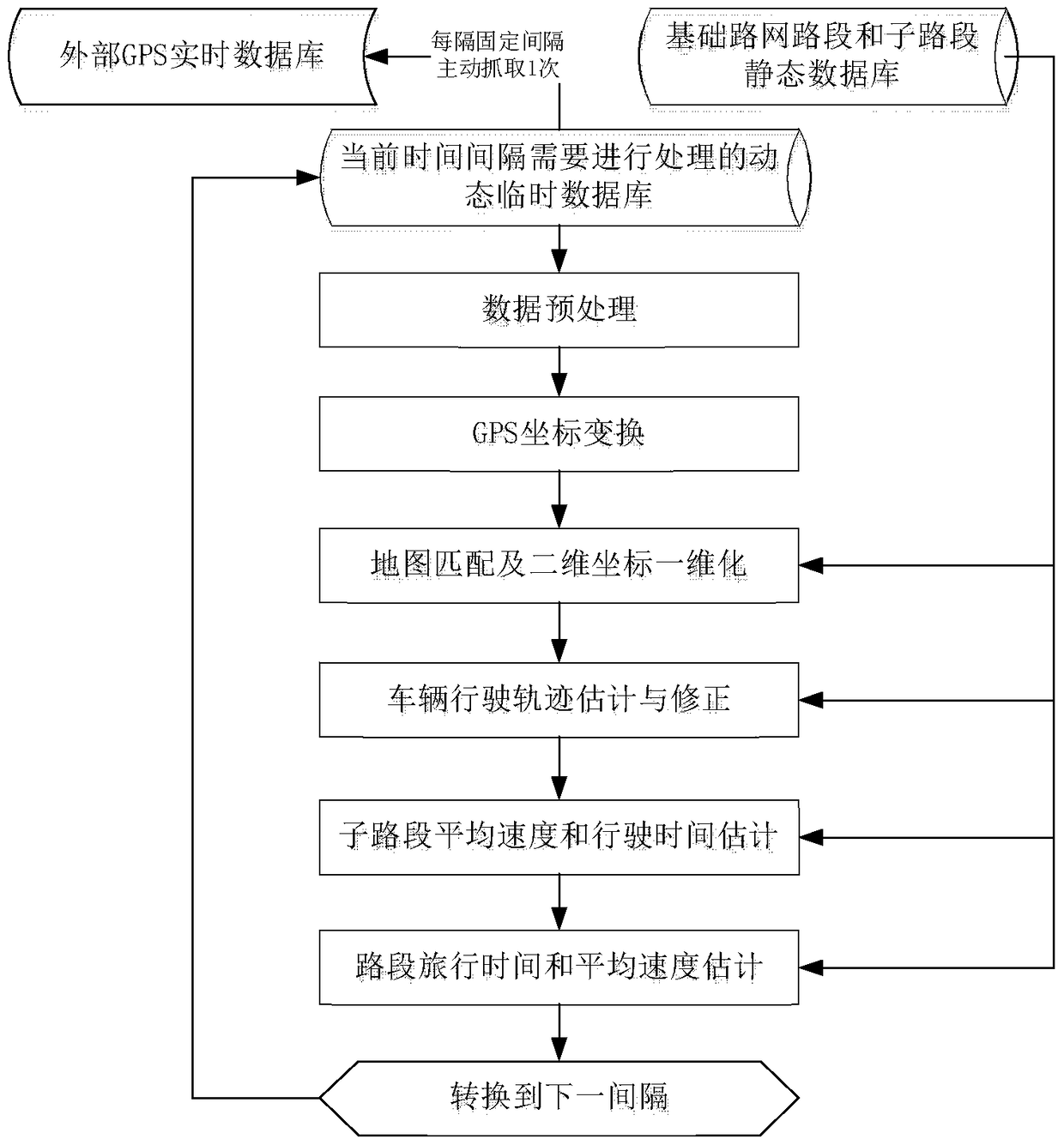
[0007] A large-scale urban road network travel time estimation method based on sparse taxi GPS data, including the following steps:

[0008] (1) Define road sections and sub-road sections, and establish a standardized static road network basic information database:

[0009] a) Define a road section and a sub-road section: the road section includes a plurality of end-to-end sub-sections;

[0010] b) Establish a standardized static road network basic information database, including road section information and sub-road section information; said road section information includes road section starting coordinates, road section end point coordinates, and road section driving directions; The coordinates of the end point and the driving direction of the sub-section;

[0011] (2) Establish a taxi GPS data dynamic data table:

[0012] First, the positioning interval is defined as the time interval for uploading the GPS coordinate data of taxis, in seconds, for example, 15 seconds; th...


PUM


Abstract

The invention relates to a wide-range urban road network travel time estimation method based on sparse taxi GPS (Global Positioning System) data. The wide-range urban road network travel time estimation method comprises the following steps: data processing and travel time estimation, wherein procedures, namely preprocessing of real-time GPS data, longitude and latitude coordinate transformation and map matching are finished in the data processing for a purpose of estimating a space-time position of single GPS equipment point location on a map; the travel time estimation part is based on the procedures, namely acquiring space-time position data of single vehicle, carrying out single-vehicle traveling track calculation, sub-road-section speed estimation and road speed estimation, and finally obtaining the travel time and the average operation speed of all the road sections of the whole network.

Description

Technical field: [0001] The invention relates to a large-scale urban road network travel time estimation method based on sparse taxi GPS data, belonging to the technical field of intelligent transportation systems. Background technique: [0002] Facing the rapid growth of urban motor vehicle ownership and the total number of residents traveling, the traffic supply capacity of large and medium-sized cities is far less than the growth of traffic demand. Coupled with frequent accidents, it is easy to cause large-scale traffic congestion or partial paralysis. The design of signal control and traffic guidance strategies, which are mainly used to improve transportation efficiency, both rely on the travel time or operating speed of the real-time traffic network. Similarly, travelers also need to keep abreast of the traffic status of the road network in order to adjust travel plans and travel routes. Therefore, studying the real-time estimation algorithm of travel time in the whole...

Claims


Application Information

Patent Timeline
Patent Type & Authority Patents(China)
IPC IPC(8): G06F17/30G06Q10/04G06Q50/30
Inventor 林永杰邹难朱琳俞洁潘述亮邢建平
Owner SHANDONG UNIV
Learn More