Method and device for determining ground line in 3D map

A three-dimensional map and determination method technology, applied in image data processing, instruments, calculations, etc., can solve the problems of low display efficiency, large amount of calculation of grounding lines, etc., to achieve high display efficiency, simple calculation, improved calculation efficiency and display. The effect of efficiency

Active Publication Date: 2015-07-01
北京中盈安信技术服务股份有限公司
View PDF4 Cites 0 Cited by
  • Summary
  • Abstract
  • Description
  • Claims
  • Application Information

AI Technical Summary

Problems solved by technology

[0010] The embodiment of the present invention provides a method and device for determining the ground line in a three-dimensional map, which is used to solve the problems in the prior art that the calculation of the ground line in a three-dimensional map requires a large amount of calculation, low display efficiency, and requires pre-vector processing. problem, to achieve the technical effects of simple calculation, high display efficiency, and no need for pre-vector processing

Method used


Image

  • Method and device for determining ground line in 3D map
  • Method and device for determining ground line in 3D map
  • Method and device for determining ground line in 3D map

Examples


Embodiment 1

[0034] In order to enable those skilled in the art to understand the present invention in more detail, the present invention will be described in detail below with reference to the accompanying drawings.

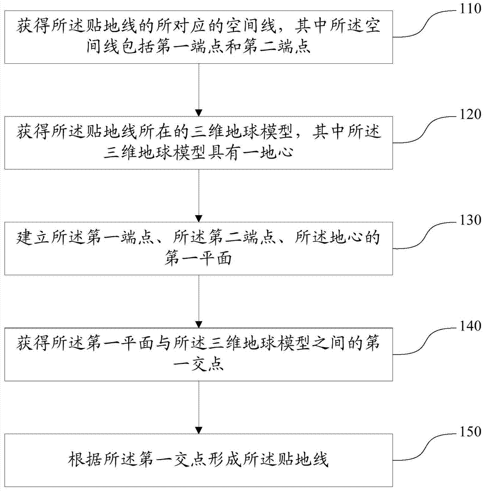
[0035] like figure 1 As shown, an embodiment of the present invention provides a method for determining a ground line in a three-dimensional map, and the method includes:

[0036] Step 110: Obtain the corresponding space line of the grounding line, wherein the space line includes a first end point and a second end point;

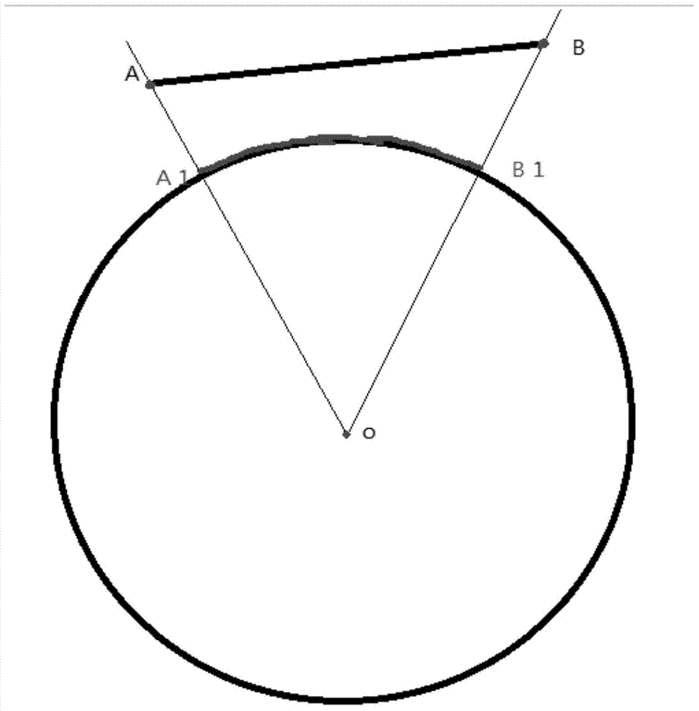
[0037] Specifically, as figure 2 As shown, the space line in step 110 is specifically AB, wherein the first end point is point A, and the second end point is point B. The embodiment of the present invention needs to obtain the grounding line A1B1 through the space line AB. Among them, A1B1 is the presentation method of the ground line of the space line AB in the 3D earth model.

[0038] Step 120: obtaining a three-dimensional earth model where the grou...

Embodiment 2

[0065] The embodiment of the present application also provides a device for determining a ground line in a three-dimensional map, such as Figure 5 As shown, the device includes:

[0066] a first obtaining module 10, the first obtaining module 10 is configured to obtain a corresponding space line of the grounding line, wherein the space line includes a first end point and a second end point;

[0067] a second obtaining module 20, the second obtaining module 20 is configured to obtain a three-dimensional earth model where the grounding line is located, wherein the three-dimensional earth model has a geocenter;

[0068] a first establishment module 30, the first establishment module 30 is configured to establish the first end point, the second end point, and the first plane of the earth's center;

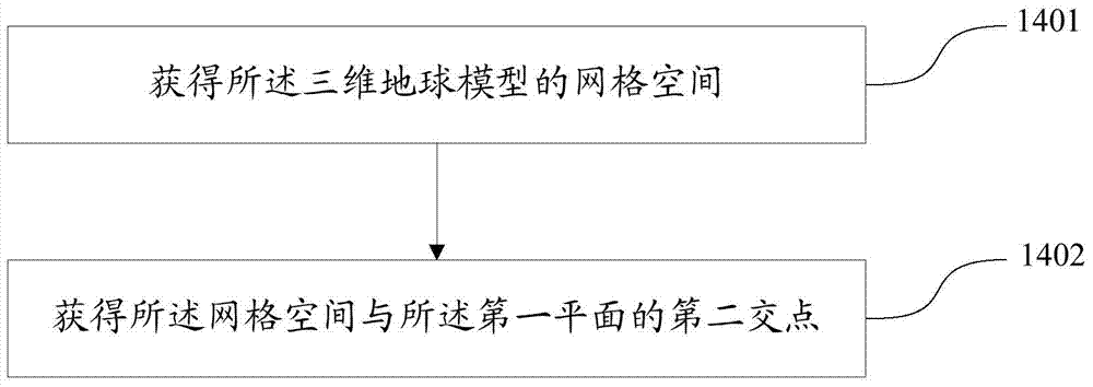
[0069] a third obtaining module 40, the third obtaining module 40 is configured to obtain a first intersection point between the first plane and the three-dimensional earth model;

...


PUM


Abstract

The invention discloses a method and a device for determining a ground line in a 3D map, and belongs to the technical field of processing of 3D maps. The method comprises the steps of acquiring a space line corresponding to the ground line, wherein the space line includes a first end point and a second end point; acquiring a 3D earth model of the ground line, wherein the 3D earth model has an earth core; building first planes for the first end point, the second end point and the earth core; then obtaining a first intersection point between the first plane and the 3D earth model; forming the ground line according to the first intersection point. The method is simple to calculate, high in display efficiency, and free of preliminary vector processing.

Description

technical field [0001] The invention relates to the technical field of three-dimensional map processing, in particular to a method and device for determining a ground line in a three-dimensional map. Background technique [0002] With the continuous development of the 3D map technology field, fast and efficient determination of the grounding line in the 3D map has become an important requirement. [0003] In general, most of the lines in three-dimensional come from vectors, and vectors are generally two-dimensional, that is, only plane coordinates and no elevation coordinates. In order to display the vector on the three-dimensional earth in space, it is often necessary to calculate the elevation information of the current vector point. [0004] For a simple point, it is a relatively simple matter to obtain the elevation value of the point on the ground. If it is extended to the line, it is necessary to obtain the elevation information of each node on the line projected on t...

Claims


Application Information

Patent Timeline
Patent Type & Authority Applications(China)
IPC IPC(8): G06T17/05
Inventor 任利伟耿蓓蕾张强
Owner 北京中盈安信技术服务股份有限公司
Why Eureka
Try Eureka