Eureka AIR delivers breakthrough ideas for toughest innovation challenges, trusted by R&D personnel around the world.

A method for analyzing the quality of lidar flight belt elevation matching

A technology of laser radar and matching quality, which is applied in the field of remote sensing, can solve the problems of inability to evaluate air belt data and low efficiency, and achieve the effect of saving manpower and material resources and comprehensive evaluation results

Active Publication Date: 2017-01-18
RES INST OF FOREST RESOURCE INFORMATION TECHN CHINESE ACADEMY OF FORESTRY
View PDF1 Cites 0 Cited by
  • Summary
  • Abstract
  • Description
  • Claims
  • Application Information

AI Technical Summary

Problems solved by technology

[0002] At present, the three-dimensional terrain and surface objects need to be analyzed by airborne lidar scanning technology. For the lidar flight mission, according to the scope of the flight area, it is usually necessary to scan multiple flight belts, and there are certain gaps between flight belts. In the overlapping area, due to factors such as flight attitude measurement error and flight belt matching processing error, it is necessary to evaluate the deviation between the point cloud elevations of the same ground object in the lidar air belt overlapping area. At present, the evaluation method of this deviation is mainly Intercepting the cross-section of the overlapping area of ​​the flight belts in the 3D view, and directly measuring the deviation between the flight belt elevations, the efficiency is low, and the data of the flight belts in the entire flight area cannot be quickly evaluated

Method used


Image

  • A method for analyzing the quality of lidar flight belt elevation matching
  • A method for analyzing the quality of lidar flight belt elevation matching
  • A method for analyzing the quality of lidar flight belt elevation matching

Examples


Embodiment Construction

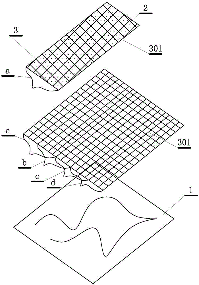
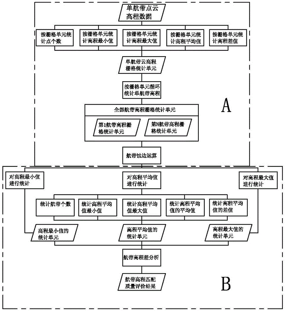
[0025] A method for analyzing the quality of lidar flight zone elevation matching, such as figure 1 and figure 2 As shown, it includes the acquisition of lidar point cloud data 2 covering multiple airways a, b, c, and d covering an area 1, which is the ground object obtained by the airborne lidar scanning system from different directions for radar scanning of the same area Echo shooting point data, there are overlapping areas between multiple flight strips, the point cloud data includes the plane coordinates and elevation data of each echo point; it obtains the echo through parameters such as GPS, IMU and laser direction vector Obtained in the three-dimensional coordinates of the point are known plane coordinates and elevation data, wherein the method includes the step of establishing a plane coordinate rasterization of the point cloud data, a step of processing the grid data of the overlapping area, and a step of outputting data results;

[0026] The described planar coordi...


PUM


Abstract

The invention discloses a method for analyzing elevation matching quality of a laser radar flight strip. The method comprises the step of acquiring a laser radar point cloud data of a plurality of air strips covering one area, wherein the overlapped areas are generated among the plurality of flight strips, and the point cloud data include the plane coordinates of each echo point and elevation data. The method comprises the steps of gridding construction point cloud data; processing grid data of the overlapped areas; outputting data results. Compared with the traditional analyzing method, the method has the advantages that the laser radar flight strip data can be automatically processed through a computer, the matching quality of the data of the plurality of flight strip data in the flight area can be quickly evaluated, the size of different grid units can be set for repeatedly processing, and therefore, the evaluation results are comprehensive, and the manpower can be saved.

Description

technical field [0001] The invention relates to the field of remote sensing, in particular to a method for analyzing the quality of laser radar navigation belt elevation matching. Background technique [0002] At present, the three-dimensional terrain and surface objects need to be analyzed by airborne lidar scanning technology. For the lidar flight mission, according to the scope of the flight area, it is usually necessary to scan multiple flight belts, and there are certain gaps between flight belts. In the overlapping area, due to factors such as flight attitude measurement error and flight belt matching processing error, it is necessary to evaluate the deviation between the point cloud elevations of the same ground object in the lidar air belt overlapping area. At present, the evaluation method of this deviation is mainly It is inefficient to intercept the section of the overlapping area of ​​the flight belt in the three-dimensional view and directly measure the deviatio...

Claims


Application Information

Patent Timeline
Patent Type & Authority Patents(China)
IPC IPC(8): G01S17/89G01S7/48
CPCG01S7/48G01S17/89
Inventor 刘清旺李增元陈尔学庞勇李世明
Owner RES INST OF FOREST RESOURCE INFORMATION TECHN CHINESE ACADEMY OF FORESTRY
Why Eureka
Eureka Blog
Learn More