Cadastral survey off-line data processing method
A technology of cadastral measurement and processing method, applied in the field of data processing, can solve problems such as difficulties
- Summary
- Abstract
- Description
- Claims
- Application Information
AI Technical Summary
Problems solved by technology
Method used
Image
Examples
Embodiment Construction
[0052] The specific implementation manners of the present invention will be further described below in conjunction with the accompanying drawings.
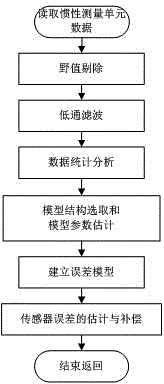
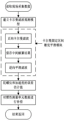
[0053] Such as Figure 1-5 Shown, the cadastral survey data processing method after the event of the present invention comprises the following steps:
[0054] Step 1. Perform data preprocessing on the inertial measurement unit data in the field collected data to remove errors.
[0055] Step 2: Classify the inertial measurement unit data after removing the error in step 1, and classify the points corresponding to known coordinates, known positions, leveling correction points, zero-speed correction points, and static measurement points on the points to be measured. The inertial measurement unit data is recorded as the first type; the inertial measurement unit data corresponding to the static measurement process on the point to be measured will be recorded as the second type during the dynamic measurement process between the two poi...
PUM
 Abstract
Description
Claims
Application Information
 - R&D
- Intellectual Property
- Life Sciences
- Materials
- Tech Scout
- Unparalleled Data Quality
- Higher Quality Content
- 60% Fewer Hallucinations
Browse by: Latest US Patents, China's latest patents, Technical Efficacy Thesaurus, Application Domain, Technology Topic, Popular Technical Reports.
© 2025 PatSnap. All rights reserved.Legal|Privacy policy|Modern Slavery Act Transparency Statement|Sitemap|About US| Contact US: help@patsnap.com


