A Modeling Method of Odometer Data for Integrated Navigation Hardware-in-the-loop Simulation

A half-in-the-loop simulation and integrated navigation technology, applied in the field of odometer data modeling, can solve the problems that the integrated navigation simulation results cannot fully reflect the actual situation, the environment is complex, and the noise characteristics of the odometer cannot be fully reflected.

Inactive Publication Date: 2017-06-06
BEIHANG UNIV
View PDF4 Cites 0 Cited by
  • Summary
  • Abstract
  • Description
  • Claims
  • Application Information

AI Technical Summary

Problems solved by technology

The environment in the actual driving process of the vehicle is relatively complex, and the given simulated noise cannot fully reflect the noise characteristics of the odometer, resulting in the integrated navigation simulation results not fully reflecting the actual situation

Method used


Image

  • A Modeling Method of Odometer Data for Integrated Navigation Hardware-in-the-loop Simulation
  • A Modeling Method of Odometer Data for Integrated Navigation Hardware-in-the-loop Simulation
  • A Modeling Method of Odometer Data for Integrated Navigation Hardware-in-the-loop Simulation

Examples


Embodiment Construction

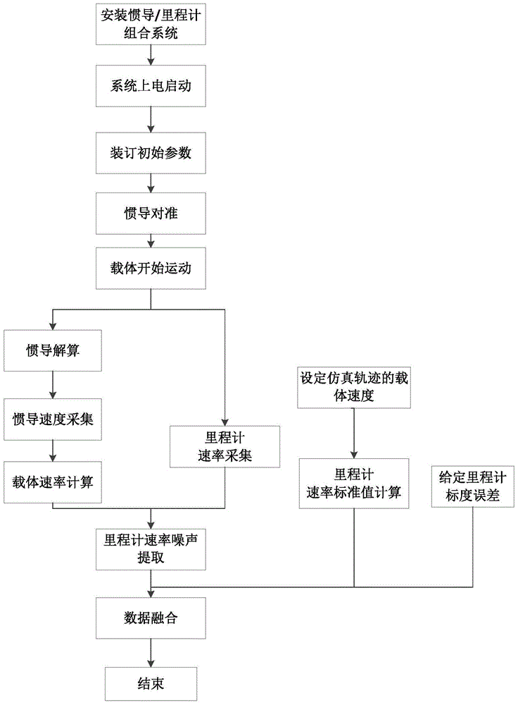
[0034] See figure 1 , figure 2 , the present invention is a kind of odometer data modeling method that is used for integrated navigation hardware-in-the-loop simulation, and the concrete steps of this method are as follows:

[0035] Step 1. Install the inertial navigation / odometer combination system on the carrier, and power it on to start.

[0036] Step 2, binding initial parameters (including initial longitude, latitude, altitude, odometer scale value) to the navigation computer.

[0037] Step 3. The carrier remains stationary, and the inertial navigation system performs static initial alignment for 5 minutes.

[0038] Step 4. After the alignment is completed, the carrier starts to move. During the movement, the inertial navigation system performs inertial navigation calculations, collects and saves the speed value output by the inertial navigation system and the speed value output by the odometer within 50 seconds after the start of movement.

[0039] Step 5. Calculate ...


PUM


Abstract

The invention discloses a mileometer data modeling method for combined navigation semi-physical simulation. The method comprises the six steps of 1, installing an inertial navigation / mileometer combined system on a carrier and starting the system by power, 2, setting initial parameters in a navigation computer, 3, keeping a carrier static state and carrying out static initial alignment on the inertial navigation unit for 5min, 4, after alignment, moving the carrier, carrying out inertial navigation calculation in movement, and acquiring and storing inertial navigation output rate values and a mileometer output speed in 50s after motion, 5, calculating a carrier rate reference value by the inertial navigation rate value, and calculating the difference of the mileometer output speed and the carrier rate reference value to obtain a noise value of the mileometer output speed, and 6, setting a simulation locus, calculating a mileometer speed standard value and a standard error value by the carrier movement rate, carrying data fusion on the speed standard value, standard error value and the noise value of the mileometer output speed obtained by the step 5 so that the mileometer rate for the combined navigation semi-physical simulation is obtained.

Description

technical field [0001] The invention relates to an odometer data modeling method for combined navigation semi-physical simulation, which belongs to the technical field of inertial navigation. Background technique [0002] The odometer is a sensor for measuring the speed and distance of the vehicle. It has the advantages of wide speed range, good dynamic performance, and measurement error does not diverge with time. It can complement the advantages of the inertial navigation system and realize fully autonomous and high-precision navigation and positioning. [0003] When carrying out inertial navigation / odometer integrated navigation simulation research, the simulation trajectory (including the moving speed, position and attitude of the carrier) is generally set, and the speed standard value of the odometer is calculated by the moving speed of the carrier in the set simulation trajectory, and then Given the scale error value and noise of the odometry, the odometry data for the...

Claims


Application Information

Patent Timeline
Patent Type & Authority Patents(China)
IPC IPC(8): G01C21/16G06F19/00G01C25/00
CPCG01C25/00
Inventor 张小跃宋凝芳时海涛易晓静刘鹏博潘建业
Owner BEIHANG UNIV
Why Eureka
Try Eureka