GIS (geographic information system)-based grid method coal resource/reserves estimation method

A grid method and reserve calculation technology, which can be used in calculations, special data processing applications, instruments, etc., to solve problems such as large errors in calculation results, improve the accuracy of reserve calculation, solve the problem of low reserve calculation accuracy, and reduce unnecessary effect of error

Inactive Publication Date: 2015-02-11
ANHUI UNIV OF SCI & TECH
View PDF5 Cites 3 Cited by
  • Summary
  • Abstract
  • Description
  • Claims
  • Application Information

AI Technical Summary

Problems solved by technology

[0007] In order to overcome the existing calculation of coal resource reserves, there are many human factors in the selection of control data for re

Method used


Image

  • GIS (geographic information system)-based grid method coal resource/reserves estimation method
  • GIS (geographic information system)-based grid method coal resource/reserves estimation method
  • GIS (geographic information system)-based grid method coal resource/reserves estimation method

Examples


Embodiment Construction

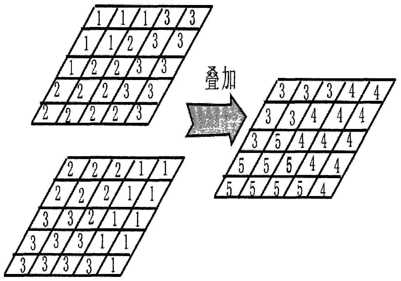
[0021] figure 1 It is a simple demonstration of the spatial overlay function of GIS.

[0022] figure 2 and image 3 It is an illustration of using the data gridding function and grid conversion function of Suffer software to fine-tune the coal seam thickness, and combining the attribute linking function of MapGis software, and using the ID number to assign the coal thickness to the grid unit.

[0023] Figure 4 and Figure 5 It is to use GIS software to assign the actual contour elevation to each contour. Use the DTM analysis module line extraction point function of MapGis software spatial analysis function to extract point elevation and save it as TmpGrid.Grd file. Use the terrain modeling function in the surf calculus module to obtain the dip angle Grd file, and then use the data grid function and grid conversion function of Suffer software to refine the thickness of the coal seam, and use the ID number to assign the coal thickness to the grid unit hint.
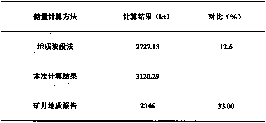
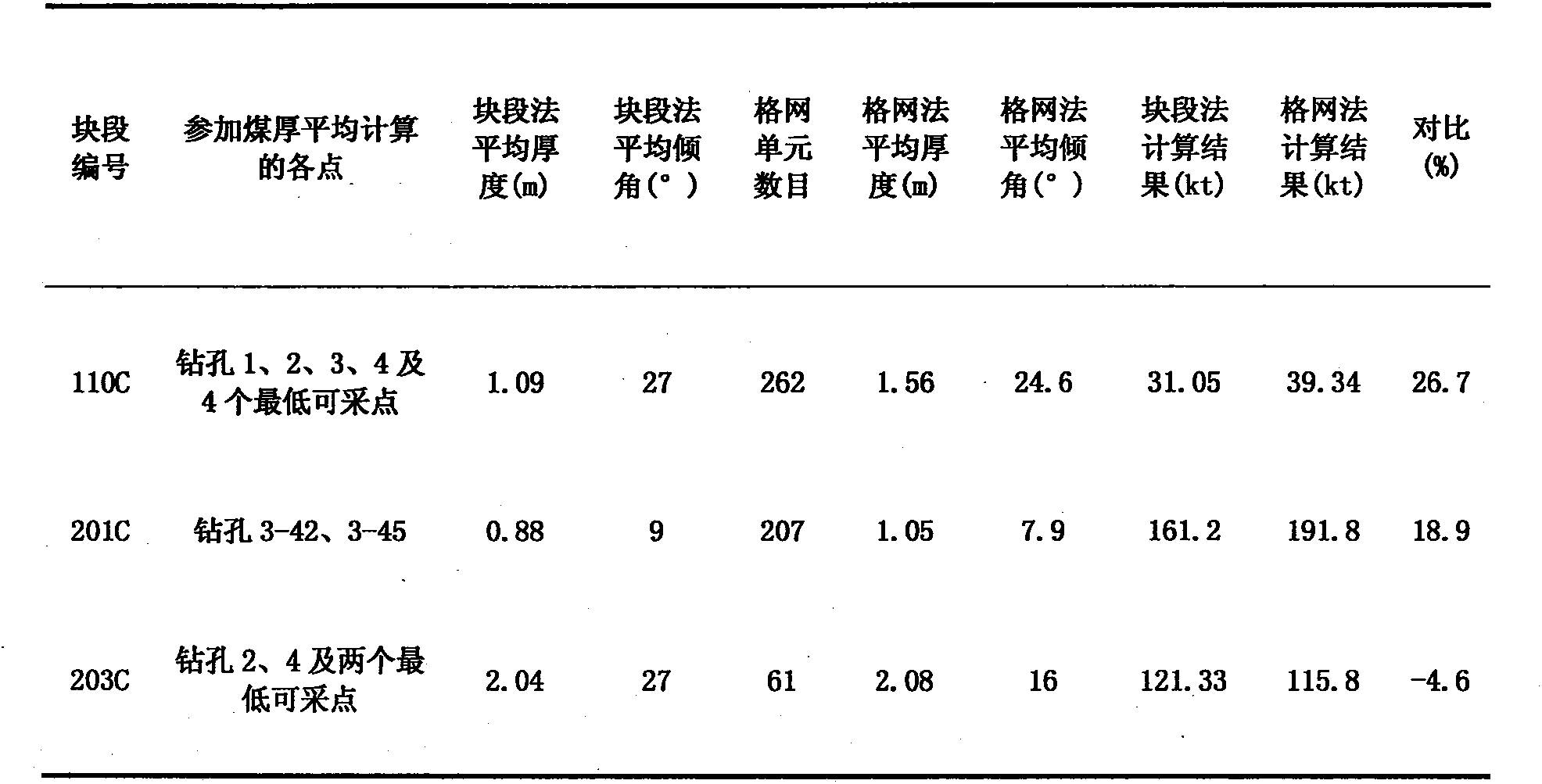
[0024] F...


PUM


Abstract

The invention discloses a method for reserves computation, which is realized through the following steps: based on the grid method, and through the adoption of the Kriging method and the surfer gridded data, contour line data is generated through the data conversion function, computation parameters are assigned to all grid cells through the mapgis software, and the spatial overlay technology is adopted for the overlapping with the computed grid range. The method overcomes the problem that the selection result of reserves computation parameter control data, such as coal-seam thickness and rock stratum dip angle, is affected by human factors.

Description

Technical field [0001] The patent of the present invention relates to a method for calculating coal resource reserves by combining space overlay technology with GIS grid method. Background technique [0002] The calculation method of mineral resource resources / reserves refers to the estimation of underground mineral deposits based on the geological information obtained in the process of geological exploration (including mining) of mineral deposits. [1] . It is a basic work in the process of coal development, and the reliability of its results is directly related to the risk of coal mine investment, the rationality of coal mine production decisions, and the effectiveness of daily work. At present, in inclined and gently inclined coal seams, coal resource reserves are calculated using methods such as block method and grid method, which are all calculation methods based on paper drawings. Although the use of computers has increased the accuracy of the resource / reserve calcula...

Claims


Application Information

Patent Timeline
IPC IPC(8): G06F19/00
Inventor 胡宝林郑凯歌程乔刘兵昌杨华泽
Owner ANHUI UNIV OF SCI & TECH
Why Eureka
Try Eureka