Monitoring method of wild animal community status based on UAV
A wild animal and drone technology, applied in the field of wild animal community monitoring, can solve the problems of lack, lack, and difference of professionals, and achieve the effect of improving monitoring efficiency, reducing workload, and reducing data volume.
- Summary
- Abstract
- Description
- Claims
- Application Information
AI Technical Summary
Problems solved by technology
Method used
Image
Examples
Embodiment 1
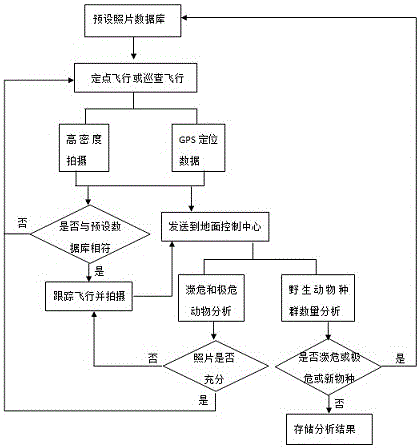
[0026] Such as figure 1 A kind of unmanned aerial vehicle-based wild animal community status monitoring method shown, is characterized in that, comprises the following steps:
[0027] 1) A 360-degree photo database of endangered and critically endangered animals is preset in the drone;
[0028] 2) Equip the UAV with a color CCD mission load or infrared detection equipment, and perform fixed-point flight or large-scale inspection flight in a specific area, while performing high-density shooting and GPS positioning functions;
[0029] 3) Send the captured pictures and GPS positioning data back to the ground control center in real time through the wireless network, and at the same time obtain the characteristic data from the photos and compare them with the preset database photos in step 1). If they match, the drone will pass Positioning information to search and track the flight; if not, continue to fly;
[0030] 4) The ground control center estimates the population of wild an...
Embodiment 2
[0033] The difference between Embodiment 2 and Embodiment 1 is that the ground control center also has a database of 360-degree characteristic photos of all animals in the target area, and compares the characteristics of photos collected by fixed-point flights or inspection flights with the database. , send an alarm, and back up the picture separately, and further analyze whether there is a new species intrusion; when it is determined that a new species has intruded, store the feature information of the new species in the preset 360-degree photo database in step 1), The same process is used for tracking and shooting of endangered and critically endangered animals, so as to realize the tracking and analysis of new species in the later stage; the ground control center analyzes and tracks the photos taken by the flight, and determines that the photo resources are sufficient to provide sufficient information for fully understanding the growth status of new species. When receiving d...
PUM
 Abstract
Description
Claims
Application Information
 - R&D Engineer
- R&D Manager
- IP Professional
- Industry Leading Data Capabilities
- Powerful AI technology
- Patent DNA Extraction
Browse by: Latest US Patents, China's latest patents, Technical Efficacy Thesaurus, Application Domain, Technology Topic, Popular Technical Reports.
© 2024 PatSnap. All rights reserved.Legal|Privacy policy|Modern Slavery Act Transparency Statement|Sitemap|About US| Contact US: help@patsnap.com


