
GPS/INS integrated navigation method based on unscented Kalman filtering

An unscented Kalman, integrated navigation technology, applied in radio wave measurement systems, satellite radio beacon positioning systems, measurement devices and other directions, can solve the problems of low accuracy, long training time, poor stability, etc., to ensure accuracy, The effect of improving accuracy and stability

Inactive Publication Date: 2013-12-11
BEIJING INST OF SPACECRAFT SYST ENG +1
View PDF1 Cites 21 Cited by
  • Summary
  • Abstract
  • Description
  • Claims
  • Application Information

AI Technical Summary

Problems solved by technology

Using the artificial neural network method, there are problems such as poor genetic ability, long training time, low precision, poor stability, etc.

Method used


Image

  • GPS/INS integrated navigation method based on unscented Kalman filtering
  • GPS/INS integrated navigation method based on unscented Kalman filtering
  • GPS/INS integrated navigation method based on unscented Kalman filtering

Examples


Embodiment Construction

[0036] The present invention will be described in further detail below in conjunction with the accompanying drawings.

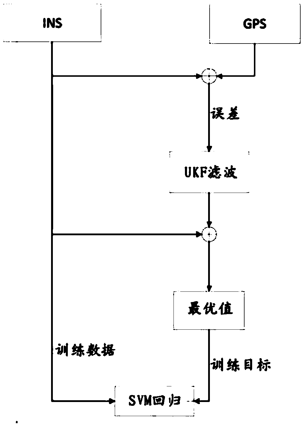
[0037] A GPS / INS integrated navigation method based on unscented Kalman filter, such as figure 1 shown, including the following steps:

[0038] Step 1. Combine the INS data and the corresponding GPS data, and use the Unscented Kalman Filter (UKF) method to establish the GPS / INS integrated navigation model and obtain the optimal value when the GPS is online.

[0039] In this step, the GPS / INS integrated navigation model is established by using the unscented Kalman filter method. The integrated navigation model is an indirect filter, and the final output is determined by the GPS data and the best error data. In this method, the error of integrated navigation is the system state, and the errors of attitude, velocity, position, gyroscope and acceleration are composed of a state vector, and the state vector X is expressed as:

[0040] X=[φ E ,φ N ,φ U ,δV E ...


PUM


Abstract

The invention relates to a GPS / INS integrated navigation method based on unscented Kalman filtering. The method is mainly characterized in that the method comprises the following steps that INS data and corresponding GPS data are combined together, and an unscented Kalman filtering method is adopted to build a GPS / INS integrated navigation model to obtain the online optimal value of a GPS; the INS data are used as training data and are combined with the online optimal value of the GPS as a training target to build an SVM regression model, and the SVM regression model is used for predicting the off-line navigation data of the GPS. According to the method, the precision of the GPS is usually combined with the reliability of an inertial navigation system to achieve the information fusion of the filtering, the GPS and an INS, and when the GPS and the INS are used together, a precise filtering result can be obtained; an SVM is adopted to train INS data obtained when GPS signals are lost, the parameters of a kernel function and a penalty function in an SVM algorithm are optimized through a simulated annealing algorithm, and the precision of the off-line GPS is kept close to that of the online GPS.

Description

technical field [0001] The invention belongs to the technical field of continuous data protection, in particular to a GPS / INS combined navigation method based on an unscented Kalman filter. Background technique [0002] GPS (Global Positioning System, Global Positioning System) is a satellite-based navigation system that can provide accurate position and speed information, so it is widely used in various navigation devices. INS (Inertial Navigation System, Inertial Navigation System) is an independent system that can provide acceleration and linear angular rate at high speed. However, its accuracy decreases significantly over time, and the error rate of position and velocity information increases. In practical applications, the above two data need to be fused, and Kalman filter (Kalman Filter, KF) is the most commonly used algorithm in GPS / INS data fusion. KF recursion in the time domain is suitable for the estimation of multivariate random processes. However, since KF is b...

Claims


Application Information

Patent Timeline
IPC IPC(8): G01S19/49G01S19/52
Inventor 刘崇华杨波张弓舒卫平姜竹青黄承恺王宇鹏门爱东
Owner BEIJING INST OF SPACECRAFT SYST ENG
Learn More