
Automation ortho-rectification method based on geometric deformation step resolving

An orthorectification and deformation technology, which is applied in computing, image data processing, instruments, etc., can solve the problems of few orthorectification solutions, lack of automation and local correction accuracy, and improve accuracy and reduce computational complexity , the effect of the simplified process

Inactive Publication Date: 2013-07-24
INST OF REMOTE SENSING & DIGITAL EARTH CHINESE ACADEMY OF SCI
View PDF3 Cites 12 Cited by
  • Summary
  • Abstract
  • Description
  • Claims
  • Application Information

AI Technical Summary

Problems solved by technology

[0005] In terms of satellite image orthorectification process, it can be seen that there are many independent researches in patents / literatures, but there are not many orthorectification solutions proposed from the perspective of the overall process, and they often have differences in automation and local correction accuracy. lacking

Method used


Image

  • Automation ortho-rectification method based on geometric deformation step resolving
  • Automation ortho-rectification method based on geometric deformation step resolving
  • Automation ortho-rectification method based on geometric deformation step resolving

Examples


Embodiment Construction

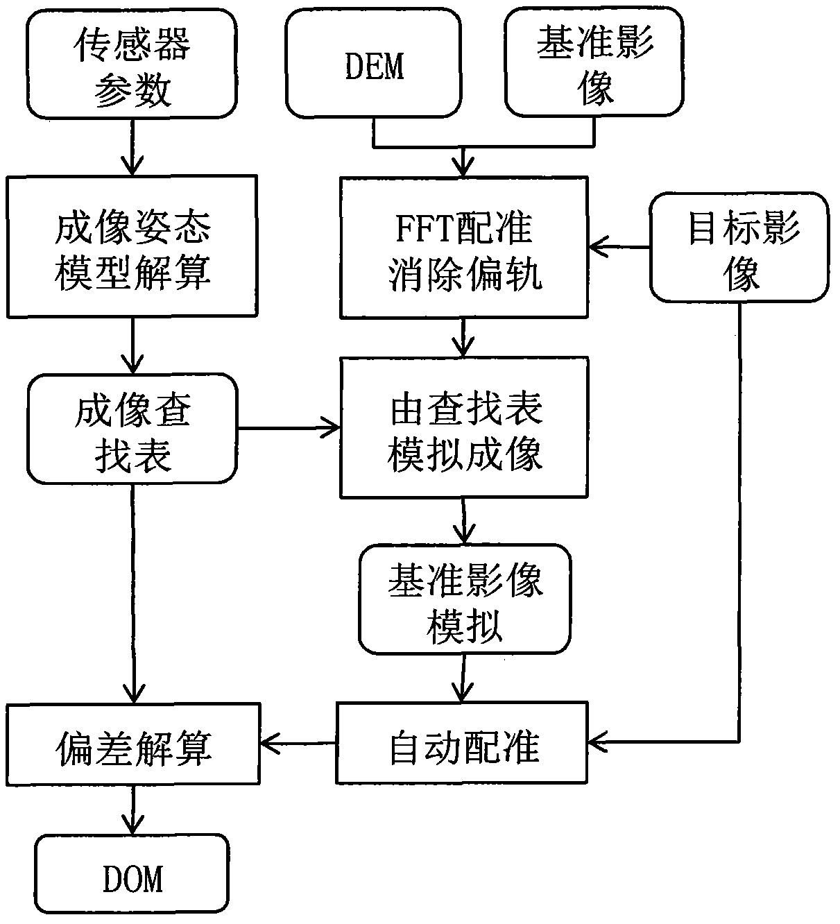
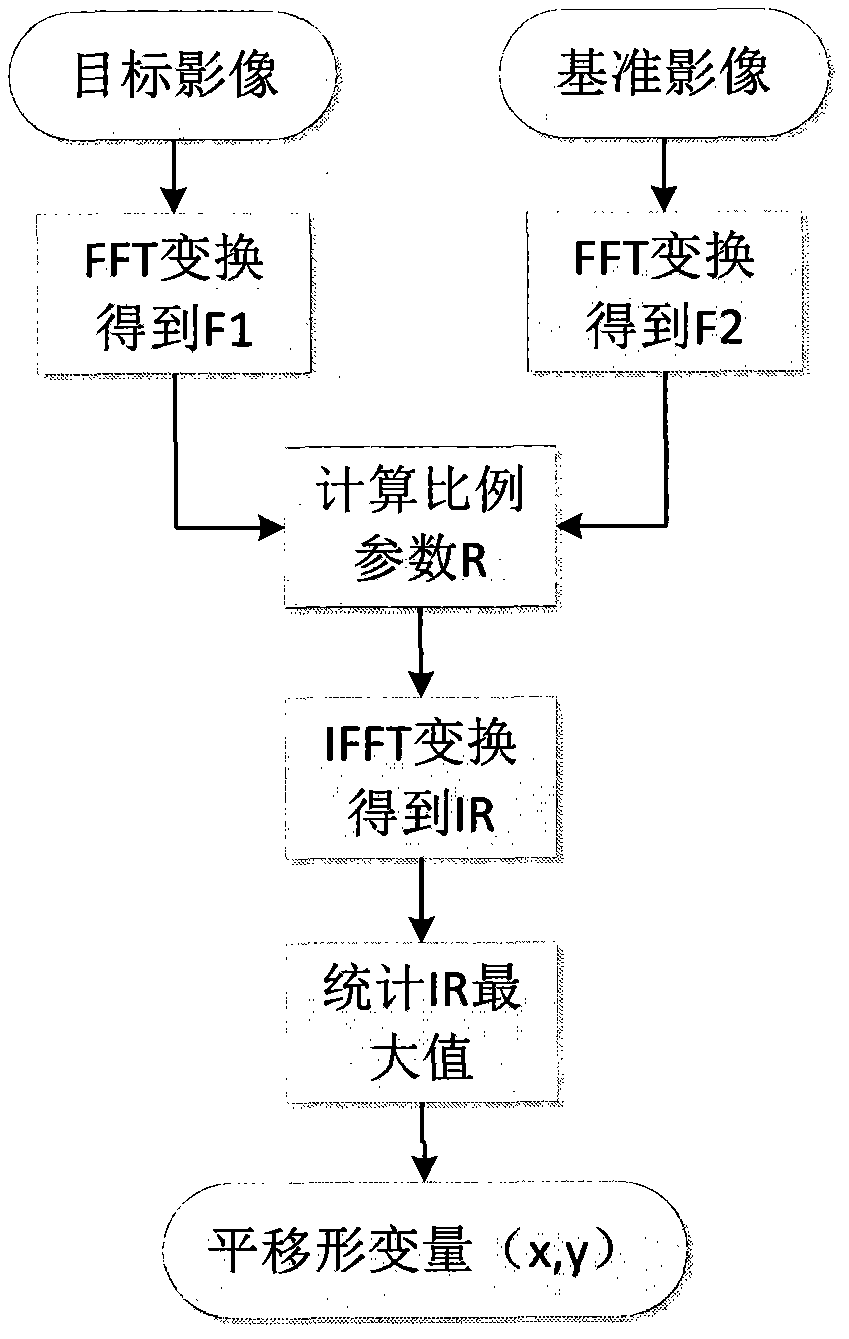
[0029] figure 1 It is the flow chart of the realization of the entire ortho-rectification process: the image suitable for this process is a medium-resolution system correction-level satellite image. In the actual implementation process, the CBERS02B and HJ star data obtained in recent years are used as experimental data. The required auxiliary data include reference images and DEM images covering the geographical range of the target data. The reference images can use orthophoto images with similar resolution. In this process, the whole process is divided into FFT registration coarse correction, simulated imaging, automatic registration There are four main steps in calculating the accuracy and terrain deviation. The specific implementation process is as follows:

[0030] First, the auxiliary data should be preprocessed to a certain extent. It is necessary to crop out the part of the same geographical range as the target image and reproject it to the same projected coordinate sy...


PUM


Abstract

The invention provides an ortho-rectification method of an automated medium resolution ratio satellite image, and particularly discloses an automation ortho-rectification method based on geometric deformation step resolving through which an ortho-rectification process of an image can be achieved fast and accurately in a region with obvious topography relief. The ortho-rectification method is built on the basis of analysis of the causes of geometric deformation in the imaging process of a remote-sensing image, different geometric deformation types are separated from one another, and step resolving is conducted to distortion caused by a conforming imaging system and distortion caused by topographic relief. Firstly, simulating irregular deformation caused by topographic relief through imaging simulation, wherein the simulate image serves as an automatic registration reference image, then rectifying confirming imaging system distortion with a polynomial model through an automatic registration method, and lastly resolving topographic deflection existing after target image registration. The automation ortho-rectification method based on geometric deformation step resolving is suitable for images shot by different sensors, other topographic deformation recorded in a lookup table is adopted in topography resolving aiming at different sensors, therefore, the computation speed of the whole rectification process is improved greatly, the ortho-rectification of the images is achieved automatically and effectively.

Description

technical field [0001] The invention relates to a remote sensing image processing technology, in particular to a correction technology for geometric deformation in a remote sensing image and an automatic image registration technology. The invention is suitable for the orthorectification process of the push-broom medium-resolution satellite image. Background technique [0002] Geometric processing of remote sensing images is a key step in preprocessing of remote sensing images, and it is the prerequisite for the correct implementation of subsequent applications such as multi-source image fusion, remote sensing image processing and information extraction. The methods that can be selected for orthorectification mainly include strict physical model and general empirical model. The strict physical model is based on the sensor conformation equation. In order to obtain higher accuracy, the orbital parameters and attitude parameters of the sensor need to be known, and the realizati...

Claims


Application Information

Patent Timeline
Patent Type & Authority Applications(China)
IPC IPC(8): G06T5/00
Inventor 张章骆剑承李均力
Owner INST OF REMOTE SENSING & DIGITAL EARTH CHINESE ACADEMY OF SCI
Learn More