
Positioning system and method based on bionic polarized light navigation

A positioning system and polarized light technology, applied in the field of positioning systems, can solve problems such as inability to use positioning, and achieve the effects of low production cost, short time consumption, and low computing performance

Active Publication Date: 2013-05-22
HEFEI INSTITUTES OF PHYSICAL SCIENCE - CHINESE ACAD OF SCI
View PDF4 Cites 35 Cited by
  • Summary
  • Abstract
  • Description
  • Claims
  • Application Information

AI Technical Summary

Problems solved by technology

However, bionic polarized light navigation can only be used for orientation, not for positioning

Method used


Image

  • Positioning system and method based on bionic polarized light navigation
  • Positioning system and method based on bionic polarized light navigation
  • Positioning system and method based on bionic polarized light navigation

Examples


Embodiment Construction

[0028] The present invention will be described in further detail below in conjunction with the accompanying drawings and specific embodiments.

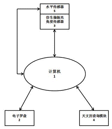
[0029] like figure 1 and figure 2 As shown, a positioning system including an electronic compass 2, a bionic polarization angle sensor 3, a level sensor 5, an astronomical calendar query module 4, a level sensor 5 and a computer 1 is set, and the computer 1 is connected to the electronic compass 2 and the bionic polarization angle sensor 3 respectively. , Astronomical calendar query module 4 is connected. The level sensor 5 is an electronic level, installed on the bionic polarized light angle sensor 3, and connected to the computer 1 through the RS-232 adapter card.

[0030] The positioning method of the present invention is as follows:

[0031] Use the electronic compass 2 to measure the angle between the carrier and the geographic north direction, that is, the heading angle α of the carrier 0 ; Adjust the bionic polarized lig...


PUM


Abstract

The invention relates to a positioning system and method based on bionic polarized light navigation. The positioning system comprises an electronic compass, a bionic polarized light angle sensor, a horizontal sensor, an astronomical calendar query module and a computer, wherein the computer is respectively and mutually connected with the electronic compass, the bionic polarized light angle sensor and the astronomical calendar query module. The positioning system and method disclosed by the invention combine astronomical navigation with the polarized light navigation, obtain the longitude and latitude of an observing point through calculation and realize positioning by natural phenomena without man-made systems, such as a secondary planet and a radio base station; and the positioning system disclosed by the invention has the advantages of simple structure, low requirement on calculated performance, low production cost, less positioning process step, short time, high measurement accuracy and very high practicability.

Description

technical field [0001] The invention relates to a positioning system and method, in particular to a positioning system and a positioning method based on polarized light bionic navigation. [0002] Background technique [0003] At present, the azimuth and angle sensors for navigation mainly include geomagnetic compass, inertial gyroscope and astronomical sextant. The principle of the geomagnetic compass is simple in structure, but the accuracy is low; the inertial gyroscope has high instantaneous accuracy in determining the direction of motion, but there will be a large accumulation error in long-term use, and other navigation sensors must be used to calibrate the inertial gyroscope; the principle of the early astronomical sextant The device is simple and has high measurement accuracy, but the positioning measurement calculation steps are many and time-consuming, so it is more limited in practice. The astronomical direction-finding sensor based on the stellar sensor has hig...

Claims


Application Information

Patent Timeline
IPC IPC(8): G01C21/00
Inventor 梅涛程珍梁华为
Owner HEFEI INSTITUTES OF PHYSICAL SCIENCE - CHINESE ACAD OF SCI
Learn More