Remote sensing image partition method based on automatic difference clustering algorithm

A clustering algorithm and remote sensing image technology, applied in the field of image processing, can solve problems such as poor detail retention performance, high computational complexity, and slow convergence speed, and achieve accurate regional consistency, overcome dependencies, and fast segmentation speed Effect

Active Publication Date: 2013-02-27
XIDIAN UNIV
View PDF3 Cites 11 Cited by
  • Summary
  • Abstract
  • Description
  • Claims
  • Application Information

AI Technical Summary

Problems solved by technology

In order to solve the shortcomings of slow convergence speed, poor stability, high computational complexity and poor detail retention performance in the existing image segmentation technology, improve the accuracy of image segmentation

Method used


Image

  • Remote sensing image partition method based on automatic difference clustering algorithm
  • Remote sensing image partition method based on automatic difference clustering algorithm
  • Remote sensing image partition method based on automatic difference clustering algorithm

Examples


Embodiment Construction

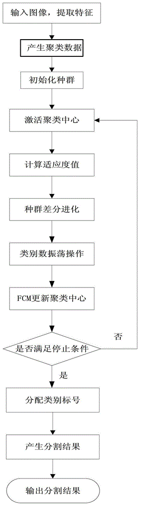
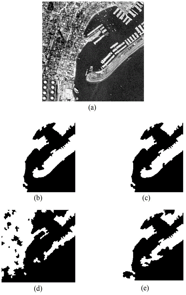
[0031] Attached below figure 1 The steps of the present invention are further described in detail.

[0032] Step 1: Input the image I to be segmented, extract the wavelet feature vector and texture feature vector of the image I to be segmented respectively, and use the wavelet feature vector and texture feature vector to represent each pixel v of the image I to be segmented.

[0033] 1a) Use the wavelet decomposition method to obtain the wavelet eigenvector:

[0034] The wavelet decomposition method uses a three-level wavelet transform with a window size of 16×16 on the image to obtain a 10-dimensional wavelet feature vector composed of subband coefficients.

[0035] 1b) Extract the texture feature vector using the gray level co-occurrence matrix method, that is, first quantize the image to be processed into 16 gray levels, and then make the angle between the line connecting two pixel points and the horizontal axis be 0°, 45°, 90° and 135°, respectively calculate the gray le...


PUM


Abstract

The invention discloses a remote sensing image partition method based on an automatic difference clustering algorithm. The method mainly solves the problems in the existing image partition technology of being high in calculating complexity and poor in partition effect. The remote sensing image partition method includes the steps: (1) inputting an image to be partitioned and extracting features of the image to be partitioned; (2) generating clustering data; (3) drawing clustering data initial population randomly; (4) activating a clustering center according to individual labels; (5) calculating an individual fitness value according to the activated clustering center; (6) evolving the population through an improved difference evolving method; (7) conducting oscillation operation of the number of categories on the evolved population; (8) updating a center of mass by using a fuzzy C means (FCM); (9) judging end conditions by using the updated center of mass and recording the optimal individuals; and (10) decoding the optimal individuals, distributing category labels and outputting partitioned images. The method has the advantages of being high in partition precision and accurate in border locating and can be used for target identification.

Description

technical field [0001] The invention belongs to the technical field of image processing, and further relates to a remote sensing image segmentation method, which can be used for target recognition. Background technique [0002] Image segmentation is the technology and process of dividing an image into several specific regions with unique properties and proposing objects of interest. At present, people mostly use methods based on cluster analysis for image segmentation. Segmenting an image with a method based on cluster analysis is to represent the pixels in the image space with corresponding feature space points, segment the feature space according to their aggregation in the feature space, and then map them back to the original image space to achieve image segmentation. the goal of. [0003] In order to obtain image segmentation information more accurately and comprehensively, in recent years, some technologies that apply automatic clustering methods to achieve image segm...

Claims


Application Information

Patent Timeline
Patent Type & Authority Applications(China)
IPC IPC(8): G06T7/00
Inventor 李阳阳焦李成王爽武小龙马文萍马晶晶李玲玲
Owner XIDIAN UNIV
Why Eureka
Try Eureka