
Mobile terminal scenery identifying system based on GPS (Global Positioning System) and image search technique

A mobile terminal and image search technology, applied in the field of scene recognition application system, can solve problems such as the difficulty of dissemination of human history knowledge, achieve the effect of promoting application development and improving the accuracy of positioning and recognition

Inactive Publication Date: 2013-02-06
HANGZHOU OUGEN TECH
View PDF2 Cites 44 Cited by
  • Summary
  • Abstract
  • Description
  • Claims
  • Application Information

AI Technical Summary

Problems solved by technology

On the contrary, the most precious cultural and historical knowledge in the scenic area is difficult to be effectively disseminated

Method used


Image

  • Mobile terminal scenery identifying system based on GPS (Global Positioning System) and image search technique
  • Mobile terminal scenery identifying system based on GPS (Global Positioning System) and image search technique
  • Mobile terminal scenery identifying system based on GPS (Global Positioning System) and image search technique

Examples


Embodiment Construction

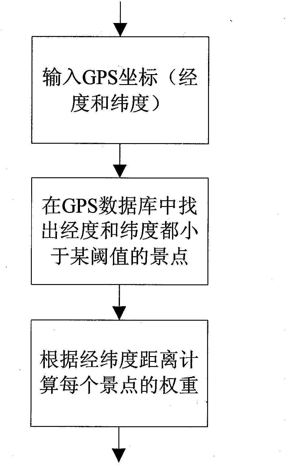
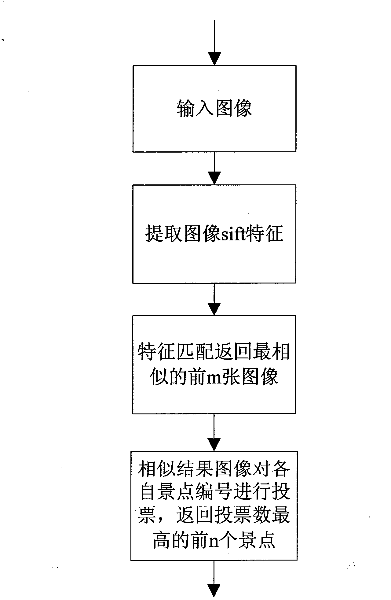
[0027] Next, an image and its GPS coordinates are used as input, and the steps of the system of the present invention are further described in detail in conjunction with the accompanying drawings. For the framework and process of the whole system, see figure 1 shown. For the input image and GPS coordinates, the image similarity result and the GPS distance similarity result are calculated respectively. Then the two types of results are voted and fused, and the number of the scenic spot with the largest number of votes is taken as the recognition result. Go to the scenic spot information database to query according to the scenic spot number, and return the relevant introduction information to the mobile client.

[0028] GPS-based location positioning such as figure 2 shown. The distance is mainly calculated based on the latitude and longitude of the GPS coordinates. In order to improve the query efficiency, first filter out those coordinates that are obviously far apart, t...


PUM


Abstract

The invention discloses a mobile terminal scenery identifying system based on a GPS (Global Positioning System) and an image search technique and relates to the field of geographical position information and technical field of image searching. The system is a novel scenery identifying system in which a traditional GPS position positioning method and a content-based image search technique are combined together to be used for identifying scenery of a mobile terminal, and the precision in identification is greatly improved. Under the situation that the GPS information is obtained incorrectly or even cannot be obtained, a user can still identify the scenery by using the image search technique in the system; and meanwhile, with the adoption of the system, the application development of the mobile terminal in the tourism industry and the transmission of the history and culture of sceneries are promoted.

Description

technical field [0001] The invention relates to the field of geographic position information and the field of image search technology, combines GPS position and image search technology, and develops a scene recognition application system on a mobile terminal. Background technique [0002] With the advancement of GPS technology and the reduction of costs in the market, it is becoming more and more common to carry GPS positioning modules on mobile terminal equipment. Coupled with the current base station positioning and Wifi positioning methods, the accuracy of mobile phone positioning is getting higher and higher. There are more and more application services based on the location of mobile phones. It is called LBS (Location Based Service) for short. However, at present, the applications based on LBS on the mobile terminal mainly stay at check-in, making friends and group buying. These applications do not require very high GPS accuracy, and are generally limited to finding ...

Claims


Application Information

Patent Timeline
Patent Type & Authority Applications(China)
IPC IPC(8): G06F17/30H04L29/08
Inventor 刘筱珉张真
Owner HANGZHOU OUGEN TECH
Learn More