Method for storing and reading grid data and device
A raster data and raster unit technology, applied in electrical digital data processing, special data processing applications, instruments, etc., can solve the problems of high transmission efficiency and large storage space, and achieve the effect of saving storage space
- Summary
- Abstract
- Description
- Claims
- Application Information
AI Technical Summary
Problems solved by technology
Method used
Image
Examples
Embodiment 1
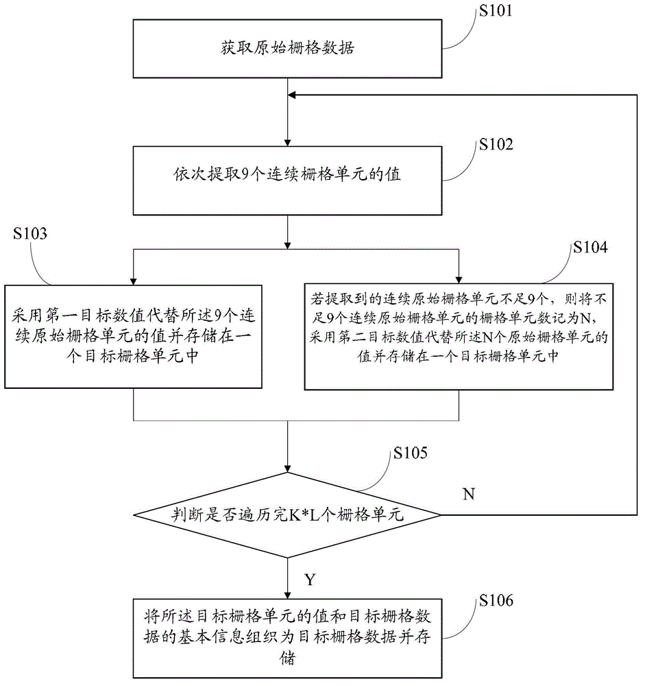
[0070] refer to figure 1 , shows a flow chart of the steps of an embodiment of a method for storing raster data in the present application. The present application is aimed at a specific type of raster data, that is, all grid cell values are integers distributed between 0 and 9 Raster data (such as the raster data describing the distribution of 56 ethnic groups in the country), this embodiment may specifically include the following steps:
[0071] Step S101, acquiring original raster data;
[0072] The original grid data includes the basic information of the original grid data and the value of the original grid unit; the basic information of the original grid data is: the original grid data includes K*L grid units; wherein, the K is row, L is a column; the values of the original grid cells are all integers distributed between 0 and 9;
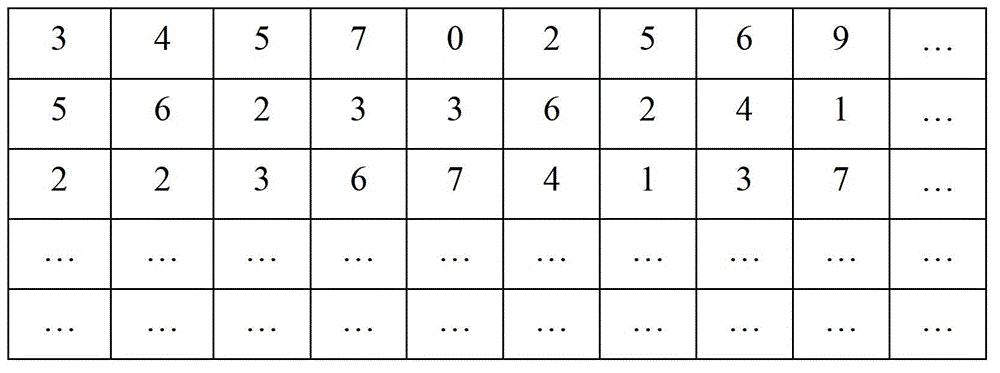
[0073] figure 2 Schematic diagram of some raster cells of the original raster data. Each grid unit of the original God grid data is s...
Embodiment 2
[0086] It should be noted that this application does not require the specific order of raster data extraction, as long as all the raster cells can be extracted in order, the original raster data can be extracted by each row, or by each column The extraction of the original raster data may also be performed on the basis of the entire raster data, which is not limited in this application. The specific process of extraction and parsing is described in detail below.
[0087] When extracting the original raster data by each row, it is assumed that the number of columns of the grid is L columns and the number of rows is K rows; for each row x (0=0 and i<=L / 9-1, numbering starts from 0) processed integers are the 9th*i of the original grid unit A total of 9 grid units from the grid unit to the 9th*(i+1)-1 grid unit are arranged continuously to form a new int value. This cycle is processed until the entire row of grid cells is processed. Then process the next row until all rows of d...
Embodiment 3
[0093] Taking the national terrain and landform raster data in the actual project as an example, compare the raster data generated by the method described in this application with other methods: in the whole country, under the condition of the same resolution of 30 meters, the raster pixel In the grid cell with a size of 161360*134724, the values from 0 to 9 represent various mountain and plain landform types respectively. In this case, if the ordinary raster data organization method in which each raster unit uses the byte type to store data is adopted, the required storage space is about 20.25Gb. If the method described in this application is used for assembly and storage, The required storage space is about 9Gb, which saves 11Gb of storage space, and uses about half of the original storage resources to store the same raster unit information. This not only saves storage space, but also reduces the amount of data read and written in files. It also reduces the amount of netwo...
PUM
 Abstract
Description
Claims
Application Information
 - R&D Engineer
- R&D Manager
- IP Professional
- Industry Leading Data Capabilities
- Powerful AI technology
- Patent DNA Extraction
Browse by: Latest US Patents, China's latest patents, Technical Efficacy Thesaurus, Application Domain, Technology Topic, Popular Technical Reports.
© 2024 PatSnap. All rights reserved.Legal|Privacy policy|Modern Slavery Act Transparency Statement|Sitemap|About US| Contact US: help@patsnap.com


