
Method and device for constructing map realizing integration of multi-road network data

A road network data and map construction technology, applied in the field of geographic information systems, can solve problems such as low retrieval efficiency, low efficiency, and inability to support path planning, etc., to achieve effective management, improve efficiency, and high-efficiency path planning.

Inactive Publication Date: 2012-10-24
INST OF REMOTE SENSING & DIGITAL EARTH CHINESE ACADEMY OF SCI
View PDF6 Cites 11 Cited by
  • Summary
  • Abstract
  • Description
  • Claims
  • Application Information

AI Technical Summary

Problems solved by technology

Because the organization method of this method is still based on the multi-layer map organization, it needs two path planning and one data table lookup, which is cumbersome and inefficient, and because it involves the retrieval of data tables, the retrieval efficiency is low. Unable to support path planning in large regional scenarios

Method used


Image

  • Method and device for constructing map realizing integration of multi-road network data
  • Method and device for constructing map realizing integration of multi-road network data
  • Method and device for constructing map realizing integration of multi-road network data

Examples


Embodiment Construction

[0036] In order to make the above objects, features and advantages of the present invention more comprehensible, the embodiments of the present invention will be further described in detail below in conjunction with the accompanying drawings and specific implementation methods.

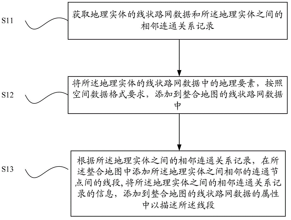
[0037] The invention provides a map construction method for integrating multi-road network data. The method integrates the linear road network data of geographical entities in an integrated area into an integrated map, and adds connections between geographical entities in the integrated map. relationship, so that the integrated map obtained based on this method can realize efficient path planning and geographic information management.

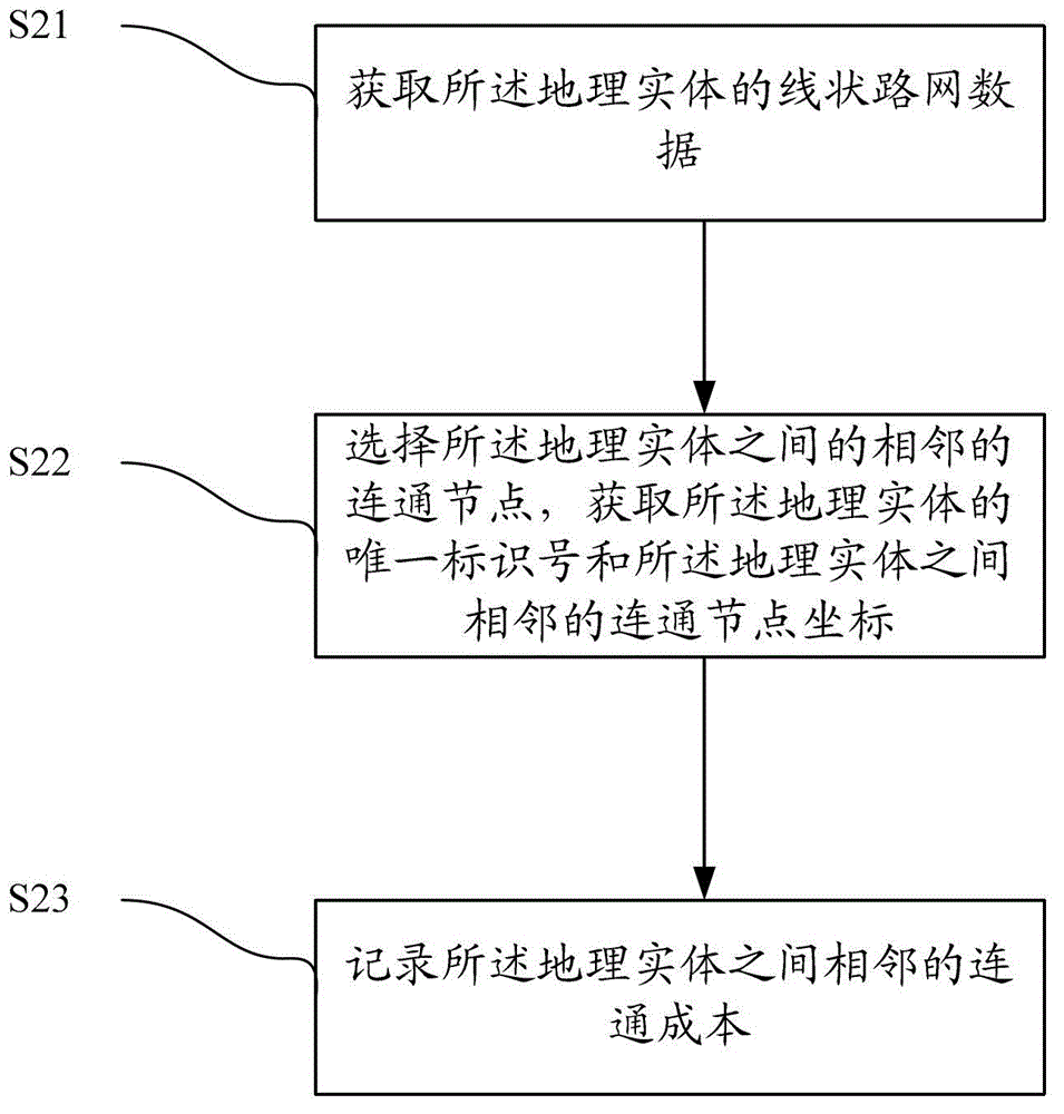
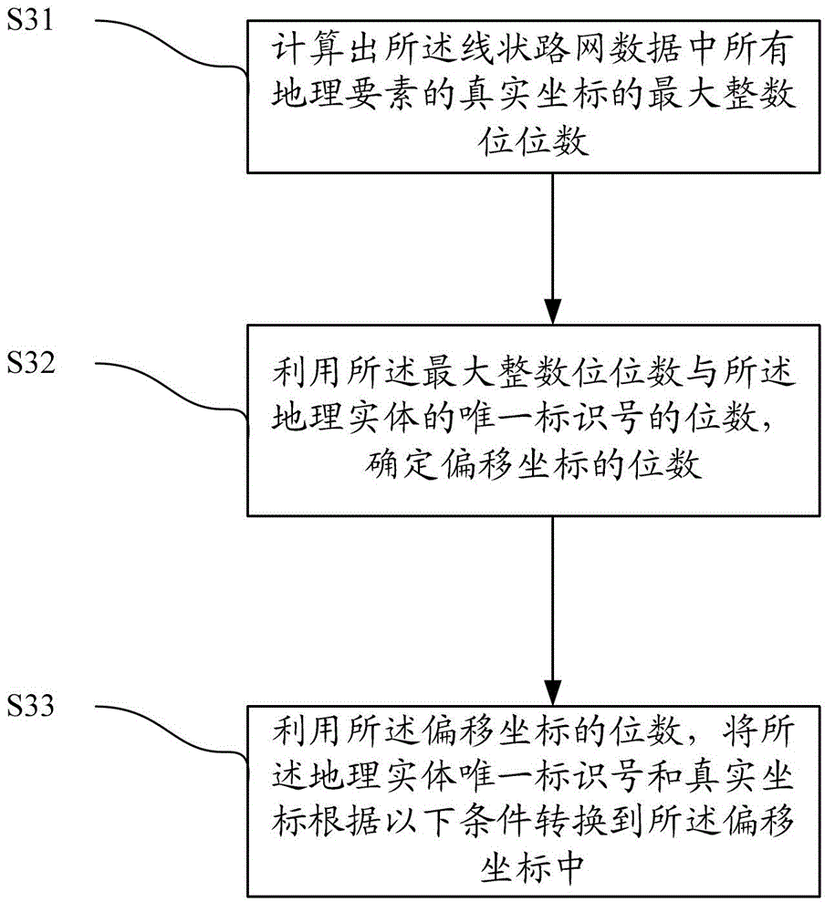
[0038] The implementation steps of this method can be found in figure 1 , including:

[0039] S11. Obtain the linear road network data of geographic entities and the adjacent connection relationship records between the geographic entities, the geographic entities are ...


PUM


Abstract

The invention discloses method and device for constructing map realizing integration of multi-road network data. The method comprises the steps of realizing the purpose of integrating the data of linear road networks of geographic entities in integrated regions into one integrated map, adding line sections between adjacent communication nodes between the geographic entities in the integrated map according to the record of adjacent communication relation between the geographic entities, adding the attributes of the data of linear road networks of the integrated map for describing the sections according to the communication cost in the adjacent communication relation record, so as to data of linear road networks of a plurality of geographic entities to be integrated a logically seamless connected complete data of linear road networks, thus being conductive to realizing effective management to geographic information in the data of linear road networks, high-efficiency road planning and other applications.

Description

technical field [0001] The invention relates to the technical field of geographic information systems, in particular to a map construction method and device for realizing the integration of multi-way network data. Background technique [0002] In the application of geographic information system (GIS) technology, a map layer is usually used to represent a continuous geographic entity in plane space, and multiple map layers are required for geographical entities that are not continuous in plane space To represent, for example, the internal structure of a floor in a building, because the data of different floors in the building is not continuous in plane space, usually a map layer is used to represent the internal structure of a floor, and n floors need n represented by map layers. The organizational structure of this map requires the support of tens, hundreds, or even tens of thousands of map layers in the construction of regional-level GIS applications. The participation of...

Claims


Application Information

Patent Timeline
Patent Type & Authority Applications(China)
IPC IPC(8): G01C21/32
Inventor 杨丽娜孙旭刘天悦池天河彭玲
Owner INST OF REMOTE SENSING & DIGITAL EARTH CHINESE ACADEMY OF SCI
Learn More