Terrain correction method for remote sensing image based on micro terrain

A remote sensing image and terrain correction technology, applied in the field of remote sensing image processing, can solve problems such as no physical meaning

Inactive Publication Date: 2013-06-19
SHANGHAI UNIV
View PDF2 Cites 0 Cited by
  • Summary
  • Abstract
  • Description
  • Claims
  • Application Information

AI Technical Summary

Problems solved by technology

Minneart correction, although the Minneart factor k is introduced to describe the anisotropy of the object surface, it has no actual physical meaning

Method used


Image

  • Terrain correction method for remote sensing image based on micro terrain
  • Terrain correction method for remote sensing image based on micro terrain
  • Terrain correction method for remote sensing image based on micro terrain

Examples


Embodiment Construction

[0064] A preferred embodiment of the present invention is described in detail as follows in conjunction with accompanying drawing: Embodiment of the present invention selects the fourth wave band of LandSat image to have collected the desired research area of ​​this embodiment, as figure 2 , 3 The digital elevation (DEM data) image and remote sensing image of the Three Gorges area in Hubei Province are shown.

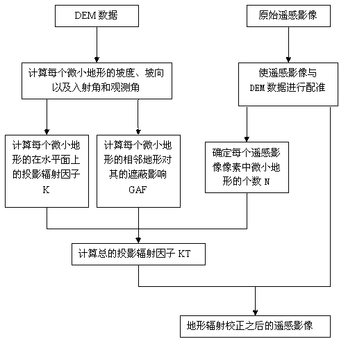
[0065] see figure 1 , the method for terrain correction of remote sensing images based on tiny terrain of the present invention, its specific steps are as follows:

[0066] (1), first use the original remote sensing image and DEM data for registration, so that the spatial resolution of the DEM is an integer multiple of the resolution of the remote sensing image, such as figure 2 , 3 shown;

[0067] (2), determine the number N of the tiny topography contained in each remote sensing image pixel;

[0068] (3) According to the DEM data and the orientation of the sun ...


PUM


Abstract

The present invention discloses a terrain correction method for a remote sensing image based on micro terrains, which comprises the following steps: registering the remote sensing image and DEM (dynamic effect model) data at first and determining the number of the micro terrains in each element of the remote sensing image; calculating the slope and the slope aspect of each micro terrain and the incidence angle and the observation angle according to the DEM data, the azimuth of the sun and the azimuth of a sensor, and calculating the projection and radiation factor of each micro terrain on thehorizontal plane and the shadowing factor of adjacent micro terrains on each micro terrain; and finally, calculating the total projection and radiation factor of each element of the remote sensing image according to the projection and radiation factor of each micro terrain on the horizontal plane, the shadowing factor of the adjacent micro terrains on each micro terrain and the number of the micro terrains in each element of the remote sensing image, and carrying out terrain correction for the original remote sensing image. By adopting the shadowing effect of the adjacent micro terrains on each micro terrain, the accuracy of the terrain correction for the remote sensing image can be increased.

Description

technical field [0001] The invention relates to a terrain correction method for a remote sensing image based on tiny terrain, and belongs to the field of remote sensing image processing. technical background [0002] Remote sensing technology has been widely used all over the world. While remote sensing data sources are developing towards higher spectral resolution and higher spatial resolution, remote sensing image processing technology is also more mature; in terms of application, the combination of geographic information system (GIS) and global positioning system (GPS) Quantitative and more quantitative development will make the application of remote sensing data more extensive and in-depth. However, in the process of remote sensing data processing, due to the huge contrast in the band radiance between the shady and sunny slopes of the mountain in the optical remote sensing images, two ground objects with the same reflection characteristics are reflected in different rad...

Claims


Application Information

Patent Timeline
Patent Type & Authority Patents(China)
IPC IPC(8): G01S7/497
Inventor 韩晓梦李先华黄微朱瑞芳陆珊
Owner SHANGHAI UNIV
Why Eureka
Try Eureka