Portable remote sensing image information field acquisition system and acquisition method

A remote sensing image and field collection technology, applied in the field of geo-information engineering, can solve problems such as inability to recognize remote sensing images, achieve the effects of enriching content, improving work efficiency and quality, and reducing burden

Inactive Publication Date: 2011-02-16
JILIN UNIV
View PDF2 Cites 12 Cited by
  • Summary
  • Abstract
  • Description
  • Claims
  • Application Information

AI Technical Summary

Problems solved by technology

Existing portable field acquisition devices do not use remote sensing images as one of the working base maps, and cannot directly identify remote sensing images on the device

Method used


Image

  • Portable remote sensing image information field acquisition system and acquisition method
  • Portable remote sensing image information field acquisition system and acquisition method
  • Portable remote sensing image information field acquisition system and acquisition method

Examples


Embodiment Construction

[0027] Below in conjunction with accompanying drawing and embodiment do further detailed description:

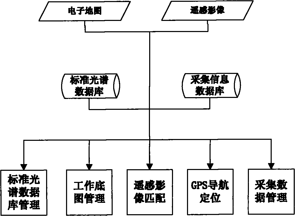
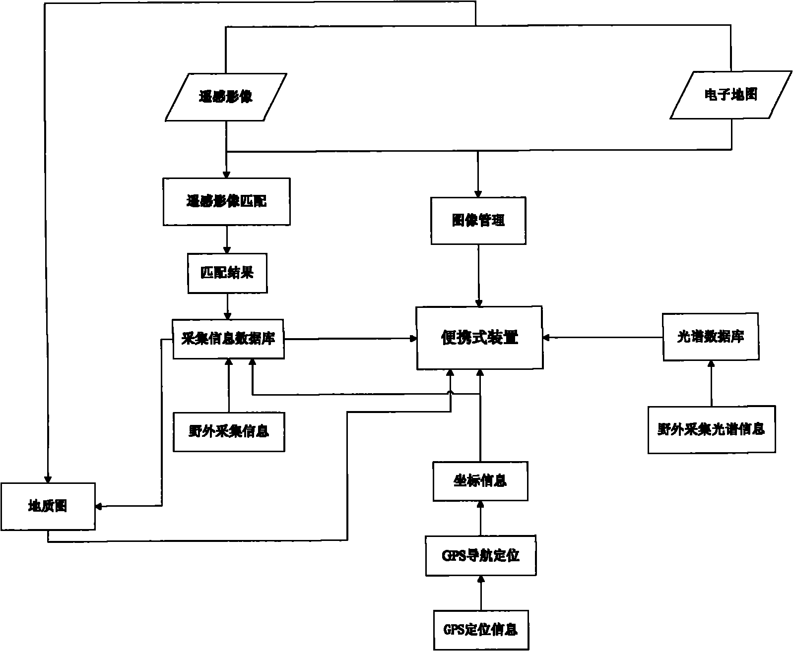
[0028] A portable remote sensing image information field collection system includes two parts: a remote sensing image information field collection device and a remote sensing image information field collection method.

[0029] The remote sensing image information field collection device is connected by the electronic map module and the remote sensing image module, and is connected with the standard spectral database module and the acquisition information database module through the data line, and then connected with the standard spectral database management module, the working map management module, and the remote sensing image matching module 1, GPS navigation positioning module and collection data management module are connected in series to form.

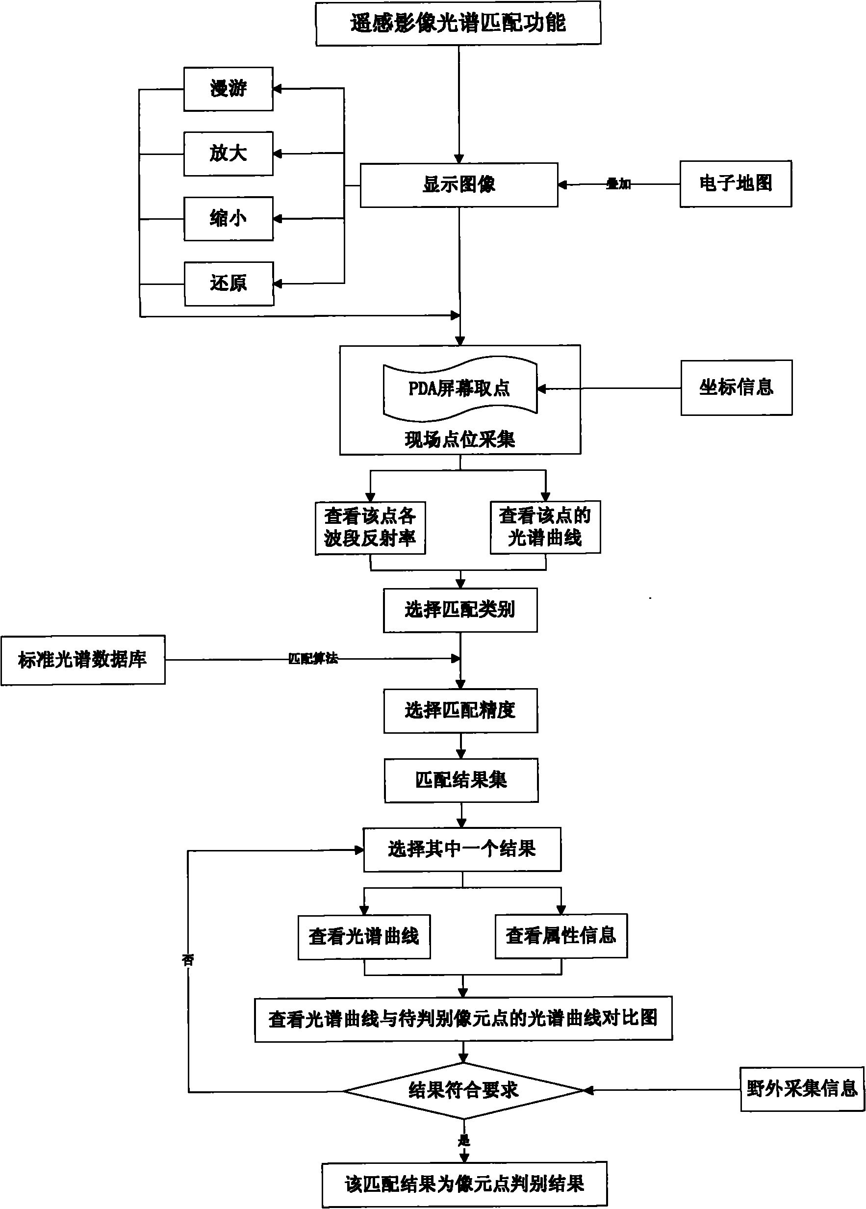
[0030] The remote sensing image information field collection method includes the following sequence and steps:

[0031] a. P...


PUM


Abstract

The invention relates to a portable remote sensing image information field acquisition system. The system comprises an electronic map module, a remote sensing image module, a standard spectroscopic database module, an acquired information database module, a standard spectroscopic database management module, a working map management module, a remote sensing image matching module, a GPS (Global Positioning System) navigating and positioning module and an acquired database management module, wherein the electronic map module and the remote sensing image module are connected and then connected with the standard spectroscopic database module and the acquired information database module through data lines; and then the connected modules are connected with the standard spectroscopic database management module, the working map management module, the remote sensing image matching module, the GPS navigating and positioning module and the acquired database management module in series. In the invention, a remote sensing image map of a working region and an electronic map are used as working base maps and introduced into an acquisition device to discriminate the type of a ground feature; and the ground feature is related onto the working base map to form a geologic map. The invention provides a convenient and quick digitalized geological information acquisition tool, lays a foundation for field paperless operations of geological work, avoids various troubles brought by carrying a large quantity of geological maps to a field site, enriches the content of geological surveys, improves theworking efficiency and the quality and lightens the burdens of field geological workers.

Description

Technical field: [0001] The invention relates to a geoscience information engineering utilizing remote sensing image information, in particular to a field collection device for remote sensing image information and a field collection method for remote sensing image information. Background technique: [0002] For geoscience research, field work is an indispensable and important link. Moreover, in the field of remote sensing applications, due to the accuracy of remote sensing image interpretation, there are inevitably errors or types that are difficult to determine, which requires field investigation and verification. . The traditional field work is to record the obtained first-hand information on the record book of paper media. The collected information has many types, complex content, large amount of information, and is greatly affected by human factors. This traditional method is becoming less and less practical for the requirements of today's information age, which greatly...

Claims


Application Information

Patent Timeline
IPC IPC(8): G01S7/48G01S17/89
Inventor 陈圣波杨莹路鹏孟治国汪自军王明常
Owner JILIN UNIV
Why Eureka
Try Eureka