
Navigating a UAV with on-board navigation algorithms with flight depiction

a technology of flight depiction and navigation algorithm, applied in the field of data processing, can solve the problems of remote control device losing communication with the uav or even being completely destroyed

Inactive Publication Date: 2006-09-12
IBM CORP
View PDF17 Cites 54 Cited by
  • Summary
  • Abstract
  • Description
  • Claims
  • Application Information

AI Technical Summary

Benefits of technology

[0014]The foregoing and other objects, features and advantages of the invention will be apparent from the following more particular descriptions of exemplary embodi...

Problems solved by technology

Because the waypoints and UAV instructions are uploaded and stored on the UAV along with the navigation algorithms needed to travel from waypoint to waypoint, the remote control device may lose communications with the UAV or even be destroyed completely, and the UAV will simply continue its mission.

Method used


Image

  • Navigating a UAV with on-board navigation algorithms with flight depiction
  • Navigating a UAV with on-board navigation algorithms with flight depiction
  • Navigating a UAV with on-board navigation algorithms with flight depiction

Examples


Embodiment Construction

Introduction

[0033]The present invention is described to a large extent in this specification in terms of methods for navigating a UAV. Persons skilled in the art, however, will recognize that any computer system that includes suitable programming means for operating in accordance with the disclosed methods also falls well within the scope of the present invention. Suitable programming means include any means for directing a computer system to execute the steps of the method of the invention, including for example, systems comprised of processing units and arithmetic-logic circuits coupled to computer memory, which systems have the capability of storing in computer memory, which computer memory includes electronic circuits configured to store data and program instructions, programmed steps of the method of the invention for execution by a processing unit.

[0034]The invention also may be embodied in a computer program product, such as a diskette or other recording medium, for use with ...


PUM


Abstract

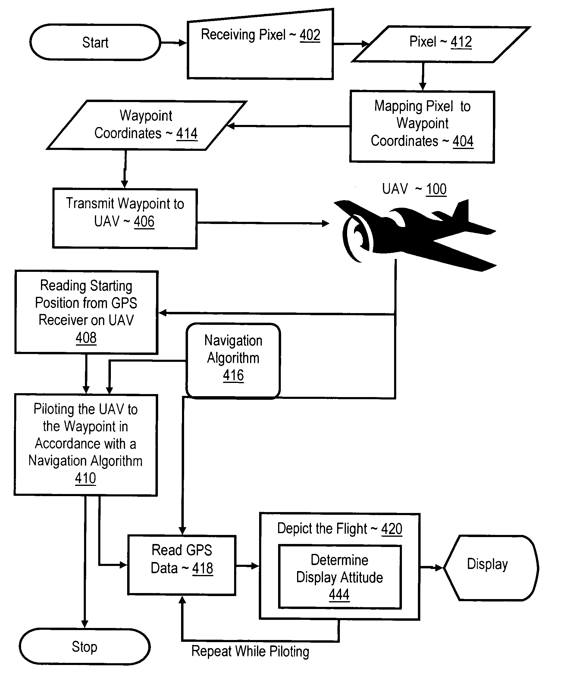
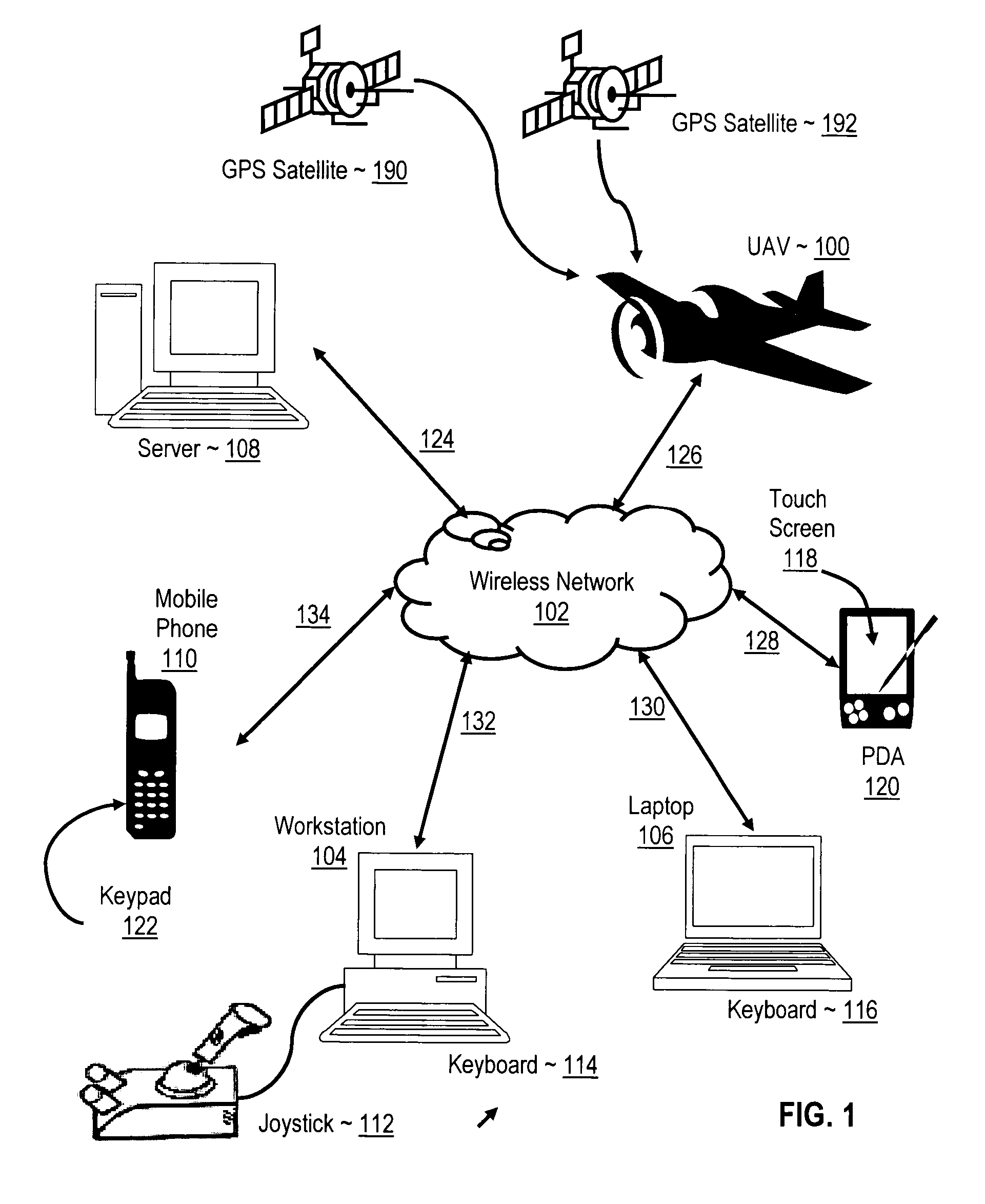
Navigating a UAV including receiving in a remote control device a user's selection of a GUI map pixel that represents a waypoint for UAV navigation, mapping the pixel's location on the GUI to Earth coordinates of the waypoint, transmitting the coordinates of the waypoint to the UAV, reading a starting position from a GPS receiver on the UAV, and piloting the UAV, under control of a navigation computer on the UAV, from the starting position to the waypoint in accordance with a navigation algorithm. While piloting the UAV from the starting position to the waypoint, such embodiments include reading from the GPS receiver a sequence of GPS data representing a flight path of the UAV, and depicting the flight of the UAV with 3D computer graphics, including a computer graphic display of a satellite image of the Earth, in dependence upon the GPS data.

Description

BACKGROUND OF THE INVENTION[0001]1. Field of the Invention[0002]The field of the invention is data processing, or, more specifically, methods, systems, and products for navigating an unmanned aerial vehicle (“UAV”).[0003]2. Description of Related Art[0004]Many forms of UAV are available in prior art, both domestically and internationally. Their payload weight carrying capability, their accommodations (volume, environment), their mission profiles (altitude, range, duration), and their command, control and data acquisition capabilities vary significantly. Routine civil access to these various UAV assets is in an embryonic state.[0005]Conventional UAVs are typically manually controlled by an operator who may view aspects of a UAV's flight using cameras installed on the UAV with images provided through downlink telemetry. Navigating such UAVs from a starting position to one or more waypoints requires an operator to have specific knowledge of the UAV's flight, including such aspects as s...

Claims


Application Information

Patent Timeline
IPC IPC(8): G01C21/28
CPCG01C21/005G05D1/0202G05D1/0044
Inventor BODIN, WILLIAM KRESSREDMAN, JESSE J. W.THORSON, DERRAL C.
Owner IBM CORP
Learn More