
Urban mapping technique for photovoltaic potential of rooftops

a technology of photovoltaic potential and rooftops, applied in the field of urban mapping techniques for photovoltaic potential of rooftops, can solve the problems of inability to model shading and reflections from adjacent urban surfaces using pvwatts, limited attention paid to assumptions and calculation methods underlying these maps, and obvious errors in neglecting variance, etc., to achieve highly accurate and detailed 3-d, and simplified lidar data

Inactive Publication Date: 2014-07-24
MASSACHUSETTS INST OF TECH
View PDF1 Cites 12 Cited by
  • Summary
  • Abstract
  • Description
  • Claims
  • Application Information

AI Technical Summary

Benefits of technology

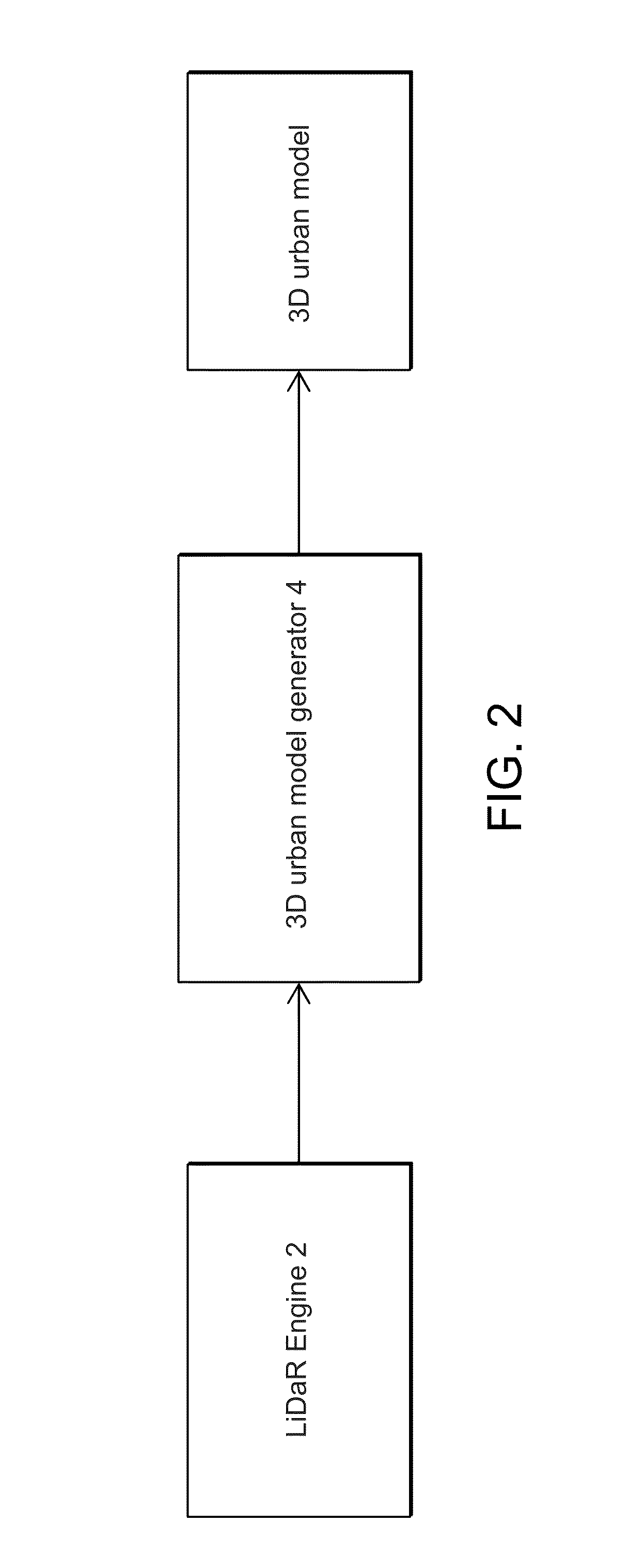
The invention is a method for creating a detailed map of a geographic area using data collected from LiDAR technology. The method involves resampling the LiDAR data over a plan grid and triangulating the data points using a Delaunay algorithm to create a highly accurate and detailed 3-D model of the area. This can be useful for generating photovoltaic maps, which can help to optimize the placement of solar cells in a region.

Problems solved by technology

While a number of cities have already generated such solar maps, to the authors' knowledge, limited attention has been paid to the assumptions and calculation methods underlying these maps.
While roof shape is treated with greater detail than in a solar constant approach, shading and reflections from adjacent urban surfaces also cannot be modeled using PVWatts.
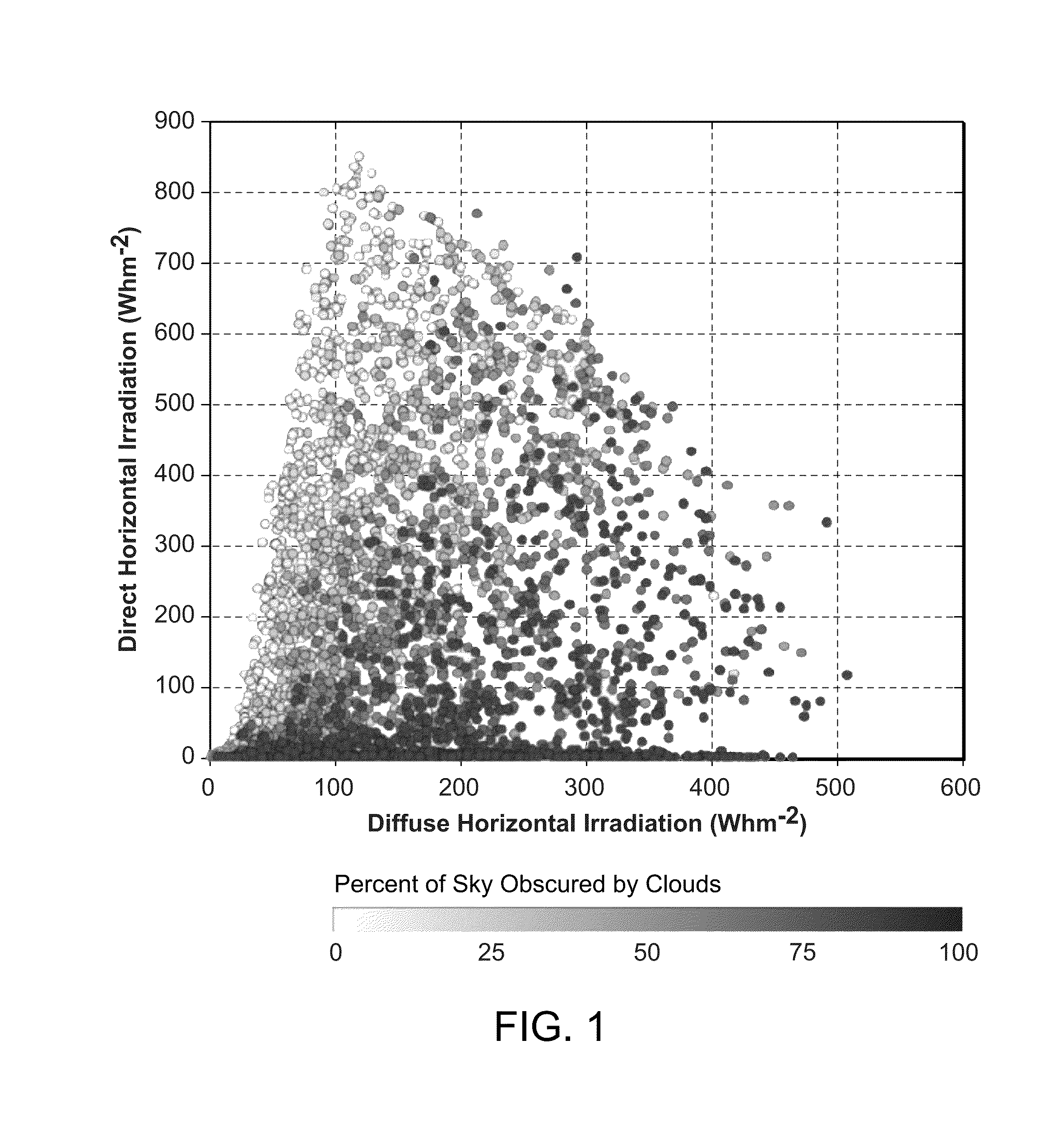
The mean direct-to-total ratio of insolation for Boston is 64%; however, the standard deviation from the mean is 31%, and neglecting this variance is obviously incorrect.
It has been proposed to assume a directional constant of reflected irradiation for obscured sky areas, but it would be inadequate to consider complex reflections from surrounding buildings.

Method used


Image

  • Urban mapping technique for photovoltaic potential of rooftops
  • Urban mapping technique for photovoltaic potential of rooftops
  • Urban mapping technique for photovoltaic potential of rooftops

Examples


Embodiment Construction

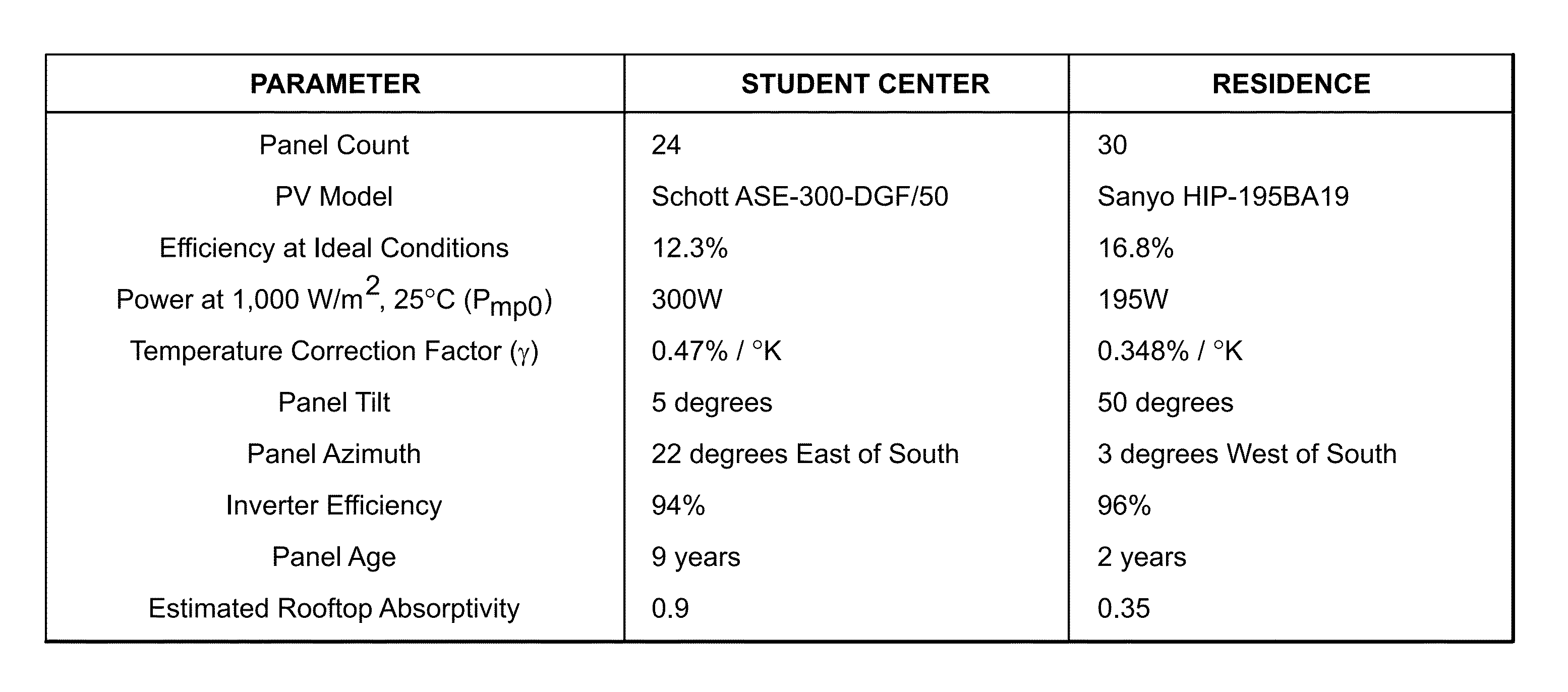
[0028]The invention demonstrates and validates a method for predicting city-wide electricity gains from photovoltaic panels based on detailed geometric urban massing models combined with DAYSIM-based hourly irradiation simulations, typical meteorological year climactic data and calculated rooftop temperatures. The resulting data can be combined with Google Maps™ type online search engines and a financial module that provides building owners interested in installing a photovoltaic system on their rooftop with meaningful data regarding spatial placement, system size, installation costs and financial payback.

[0029]Overall the method constitutes a first attempt at linking increasingly available GIS and LiDAR based urban databases with state-of-the-art building performance simulation engines. A comparison of irradiation simulations and geometry generation methods reveals that the new methodology outperforms its predecessors as it produces hourly data, supports better geometric accuracy, ...


PUM


Abstract

A photovoltaic map generator is provided that includes a data generator that provides LiDAR data illustrating detailed information of a geographic area. A model generator receives the LiDAR data and uniformly resamples the LiDAR data over a plan grid of specified spacing to produce simplified LiDAR data. The data points of the simplified LiDAR data are triangulated using a Delaunay algorithm to produce a highly accurate and detailed 3-D model of the geographic area.

Description

SPONSORSHIP INFORMATION[0001]This invention was made with government support under Grant No. EFRI-1038264 awarded by the National Science Foundation. The government has certain rights in the invention.PRIORITY INFORMATION[0002]This application claims priority from provisional application Ser. No. 61 / 755,600 filed Jan. 23, 2013, which is incorporated herein by reference in its entirety.BACKGROUND OF THE INVENTION[0003]The invention is related to the field of map generation, and in particular to an urban mapping technique for photovoltaic potential of rooftops.[0004]It has become increasingly popular for cities and municipalities to create solar potential maps with the intent of promoting renewable energy generation through photovoltaic (PV) panel installations within those jurisdictions. In the United States, large cities such as Boston, Los Angeles, New York City and Portland provide online maps which allow building owners to look up their address and view personalized predictions o...

Claims


Application Information

Patent Timeline
Patent Type & Authority Applications(United States)
IPC IPC(8): G06F17/50
CPCG06F17/5009G06F30/20
Inventor REINHART, CHRISTOPH F.JAKUBIEC, JOHN ALSTAN
Owner MASSACHUSETTS INST OF TECH
Learn More