Method, System and Computer Program Product for Optimizing Route Planning Digital Maps

Inactive Publication Date: 2013-07-11
UNIV OF VIRGINIA ALUMNI PATENTS FOUND
View PDF2 Cites 71 Cited by
  • Summary
  • Abstract
  • Description
  • Claims
  • Application Information

AI Technical Summary

Benefits of technology

The present invention provides a system, method, and computer program product that allows for the development and maintenance of optimized digital network maps. This includes creating and assigning costs to road segments based on driver or system user preferences, providing analysis for city planners and transportation engineers, and streamlining integration into current route-planning software. The optimized digital map can be used for route guidance, providing analysis for multi-stop routes and tailored marketing, among others. Additionally, the invention allows for easy integration into existing route planning software.

Problems solved by technology

The inability of traditional routing systems to account for non-quantified network segment factors is particularly problematic for specialized users such as emergency responders, logistics companies, or military units that may not use standard metrics such as shortest time or distance as their metric for route optimization.
However, traditional approaches to digital network map development, optimization, and maintenance have significant limitations.

Method used


Image

  • Method, System and Computer Program Product for Optimizing Route Planning Digital Maps
  • Method, System and Computer Program Product for Optimizing Route Planning Digital Maps
  • Method, System and Computer Program Product for Optimizing Route Planning Digital Maps

Examples


examples

[0073]Practice of an aspect of an embodiment (or embodiments) of the invention will be still more fully understood from the following examples and experimental results, which are presented herein for illustration only and should not be construed as limiting the invention in any way.

Experimental Results and Examples Set No. 1

[0074]FIG. 10 represents an optimized route planning map for San Francisco, Calif. generated by the use of an embodiment of the present invention digital map optimization system or method. An aspect of the preferred data originated from the use of real-world data (taxi cabs) sample. The map illustrates the optimized route whereby the route is not necessarily the shortest available route (between the starting point, S, and destination point, D), but rather the most preferred route based on the algorithm of an embodiment generating the optimum route planning digital map.

Experimental Results and Examples Set No. 2

[0075]FIG. 11 represents an optimized route planning ...


PUM


Abstract

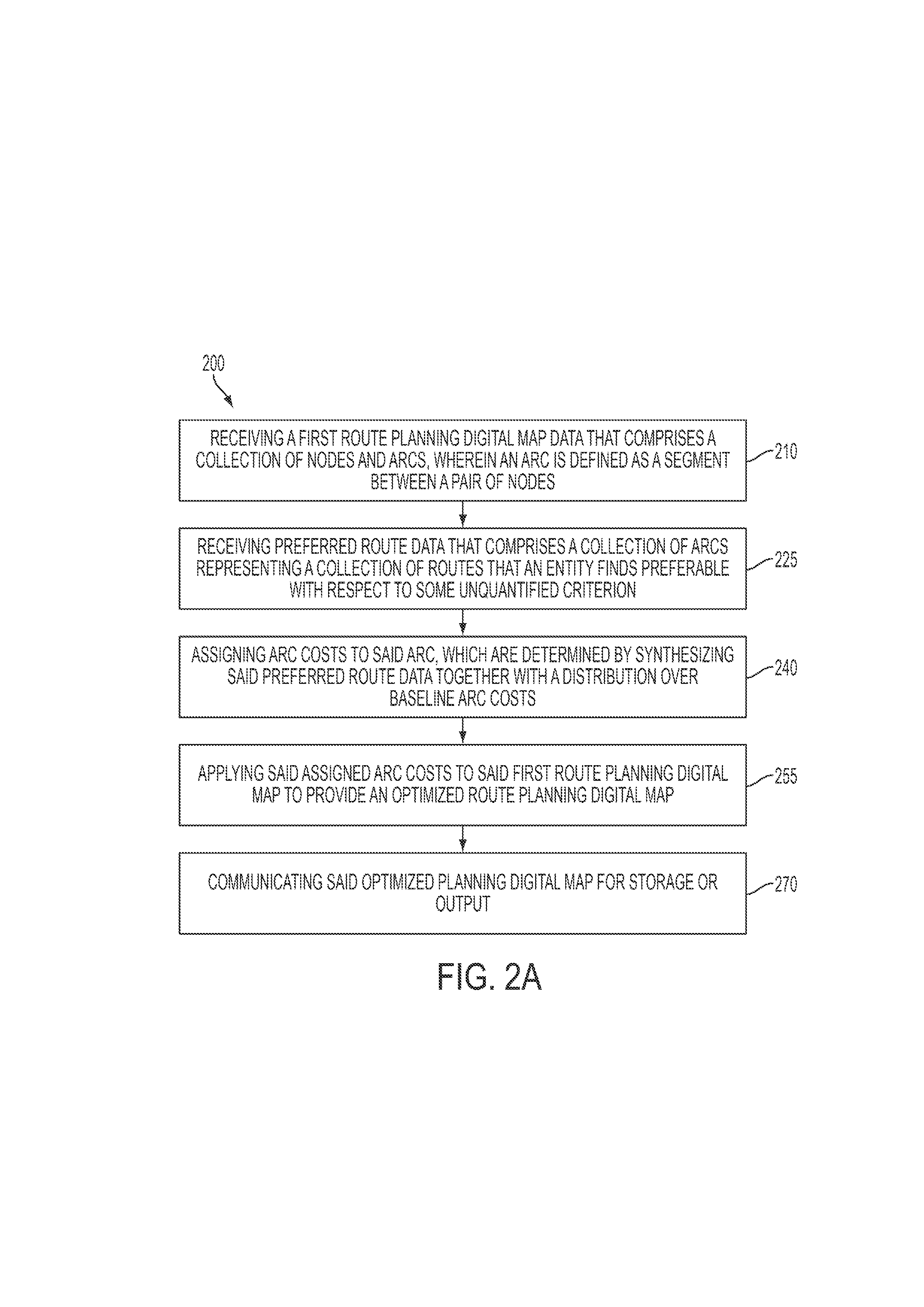
A system for digital network map development and maintenance. The system provides for optimizing digital network maps that serve as the reference basis for location-based systems such as, but not limited to, route guidance, multi-modal transportation system monitoring, location-based consumer applications, and vehicle fleet administration. The system provides the ability to develop and maintain digital route maps derived at least in part from data on the routes that drivers or users actually travel to update a digital map. For a route defined between two or more points, costs may be assigned to each road segment. As such, given a collection of route preferences, an algorithm is provided that is capable of generating an optimized route planning digital map by finding and assigning a set of costs to road segments in a way that is consistent with these preferences.

Description

CROSS-REFERENCE TO RELATED APPLICATIONS[0001]The present application claims priority from U.S. Provisional Application Ser. No. 61 / 387,753, filed Sep. 29, 2010, entitled “Method, System and Computer Program Product for Learning Based Route Planning” and U.S. Provisional Application Ser. No. 61 / 387,703, filed Sep. 29, 2010, entitled “Method, System and Computer Program Product for Learning Based Route Planning;” the disclosures of which are hereby incorporated by reference herein in their entirety.FIELD OF THE INVENTION[0002]The present invention relates to the field of digital network map development and maintenances. More specifically, the present invention relates to the field of optimizing digital network maps that serve as the reference basis for location-based systems such as, but not limited to, route guidance, multi-modal transportation system monitoring, location-based consumer applications, and vehicle fleet administration.BACKGROUND OF THE INVENTION[0003]Over the past few ...

Claims


Application Information

Patent Timeline
IPC IPC(8): G01C21/34
CPCG01C21/34G01C21/3484
Inventor TROWBRIDGE, MATTHEW J.COGILL, RANDY L.
Owner UNIV OF VIRGINIA ALUMNI PATENTS FOUND
Why Eureka
Try Eureka