Eureka AIR delivers breakthrough ideas for toughest innovation challenges, trusted by R&D personnel around the world.

Method and apparatus for sending, retrieving and planning location relevant information

a technology of location relevant information and method, applied in the direction of electrical programme control, program control, instruments, etc., can solve the problems of not enabling the transfer of location relevant information to other users in real-time, application does not provide a method for dynamically and graphically transferring location relevant information coupled with a spatial map

Inactive Publication Date: 2004-03-18
TELECOMM SYST INC
View PDF31 Cites 542 Cited by
  • Summary
  • Abstract
  • Description
  • Claims
  • Application Information

AI Technical Summary

Benefits of technology

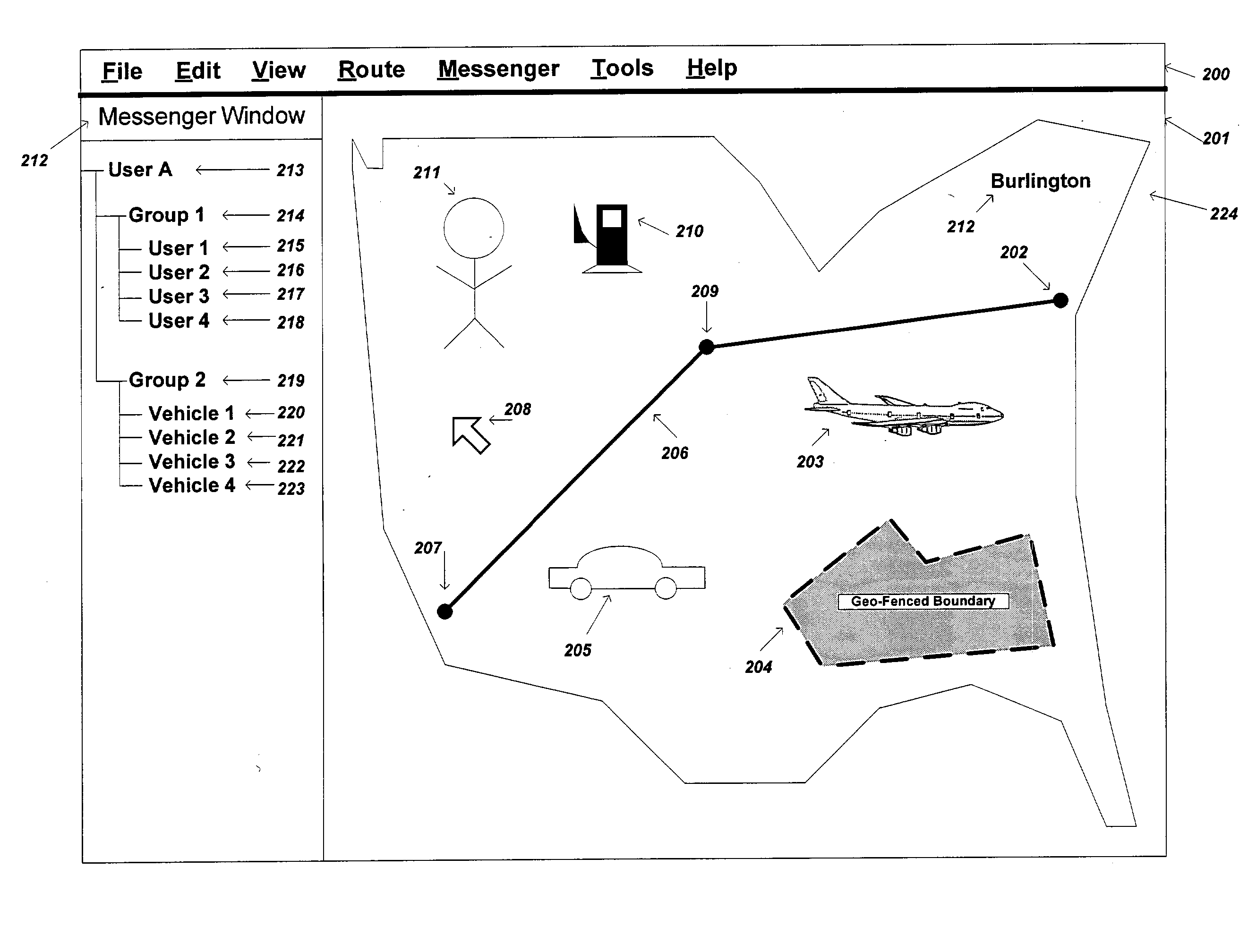
[0021] Upon accepting the request to send their position information, the requesting user's real-time communication program would receive the remote user's position information from the remote user and transfer the remote user's position information to the requesting user's mapping application to be displayed on a graphical map. The remote user can also be considered to be in the form of an online database storage system. In essence, all of the previous steps are performed using a simple selection and drag-and-drop operation. It should be noted that the mapping application and the real-time communication application do not have to be fully integrated (i.e., they can be separate applications), but do preferably include a conduit for transferring position information between the two applications. Integrating the two applications typically provides for a better user experience, but is not required by this object.
[0041] It is another object of the present invention to provide a method and system for generating a graphical route history based on a dynamically generated or changing route. A pre-calculated route with two or more destination points will be recalculated when any of those destination points change due to a position update via the real-time communication system. Instead of deleting the previous pre-calculated-route, the route portion that is different from the original route is graphically displayed differently than the recalculated route, thus providing the user with a greater amount of information. In one embodiment, an icon representation of a location-relevant object, such as a car, that has been included into a pre-calculated route along with a stationary POI, such as a gas station, can initially display the pre-calculated route on a map. If the car's position, as updated via the real-time communication system, changes and is updated on the map display, such that the previous pre-calculated route no longer applies, a new route can be calculated based on its new position information and displayed. The previous pre-calculated route can be displayed using a different highlighted color and pattern than the new route that was just calculated. Another benefit of this object is that if there are two or more destinations (i.e., three or more route points) the entire route does not have to be recalculated, but only the portion of the route that has changed will be displayed differently than the new route segment.

Problems solved by technology

None of these prior art IM software applications contain mapping capabilities.
Prior art applications provide various features, such as displaying driving directions (i.e., routes), Points Of Interest (POI), waypoints (such as personalized, user-specific, points on a route or along a track), etc., but do not enable the transfer of such information to other users in real-time.
However, these existing applications do not provide a method for dynamically and graphically transferring location-relevant information coupled with a spatial map.
Additionally, these applications typically provide only one-way transfer of position information, from the mobile vehicle to the dispatcher application, either on a web-based or desktop-based program.
Another problem with existing AVL software solutions are that most applications are web-based applications that only allow for static image-based mapping, such as those provided by various online mapping companies like MapQuest.
These static image-based mapping applications do not enable real-time graphical manipulation of POIs on the map, nor do they provide a graphical connection between the map and vehicle roster listing.
However, these solutions do not enable the user to select a vehicle on the map, nor a stationary representation of a vehicle in a roster list, in real-time for the purpose of sending the vehicle's location to other users, and thus do not allow the creation of ad-hoc position transfers between various parties.
However, prior art fails to provide real-time communication capability with location-relevant information (i.e., POIs) for the purpose of graphically sending location-relevant information in established or ad-hoc networks to other users or location-enabled devices.
Another problem with prior art, such as in the case of AVL software solutions, is that vehicles or other mobile devices that a user wishes to map must first be selected from a list of available position-enabled vehicles.
These vehicles, however, must already be configured for mapping on a dispatcher's mapping application and do not enable position requests in an ad-hoc environment.
Additionally, prior art AVL systems do not allow for the case of users or devices to disallow their position from being mapped on the current mapping application.
Another drawback of prior art is that integrated mapping and communication programs, such as AVL applications, provide the ability for the receiving of position information for mapping purposes only.
These prior art systems do not provide the capability of sending, or pushing, location-relevant information, such as POIs, to other mapping programs or textual devices, such as Personal Digital Assistants (PDA), pagers, cell phones, etc.
For instance, prior art mapping systems, such as Microsoft's MapPoint, allow the user to select POIs, such as restaurants and gas stations, but does not allow the user to transfer these POIs to other users, and more specifically does not allow users to graphically drag-and-drop these selections (i.e., POIs) for various purposes, such as to dynamically add them to a route planner for inclusion in an undefined route or pre-calculated route.
Prior art systems, such as AVL software, also fail to provide the capability of allowing the map application user (i.e., in the case of an AVL software solution the user is typically denoted as the dispatcher) to send the position information of one vehicle to another vehicle on the user's roster list for an ad-hoc location transfer.
As an additional drawback of prior art systems, there is no way to provide real-time route planning of a system consisting of a real-time communication system integrated with a mapping and real-time communication program.
In other words, it is not currently possible for a roster icon representation of a vehicle or user to be graphically selected into, or dragged-and-dropped onto, a route planner for the purpose of setting a user's current position as a route's destination points, where the term `destination` refers to a point or location on a map that the user indicates as a start of a trip, end of a trip, or stop or waypoint along a trip.
However, current art systems do not allow the capability of selecting real-time location-enabled or static POIs (such as vehicles, restaurants, people, gas stations, houses, etc.) for the purpose of graphically adding to, or updating, a route's destination points in an undefined or pre-calculated route.
Additionally, this prior art system application only allows the alteration of a route to a new destination by dragging the selected portion of the route to that new location.
An additional problem with current map planning applications or integrated mapping and real-time communication software applications, such as AVL software solutions, is that they do not provide the capability of allowing users to graphically transfer routes to other users in real-time.

Method used


Image

  • Method and apparatus for sending, retrieving and planning location relevant information
  • Method and apparatus for sending, retrieving and planning location relevant information
  • Method and apparatus for sending, retrieving and planning location relevant information

Examples


Embodiment Construction

[0077] The details of the preferred embodiments of the present invention will now be described with references to FIGS. 1-32.

[0078] The present invention provides a method and system for graphically sending (and sharing), retrieving, and planning location-relevant information with a mapping and real-time communications applications, where both applications can be integrated into one application or each application is separate and capable of communicating with the other. The present invention may be embodied in a mapping and real-time communication application, such as the "Map Messenger" application owned and licensed by the Networks In Motion Corporation of Pasadena, Calif.

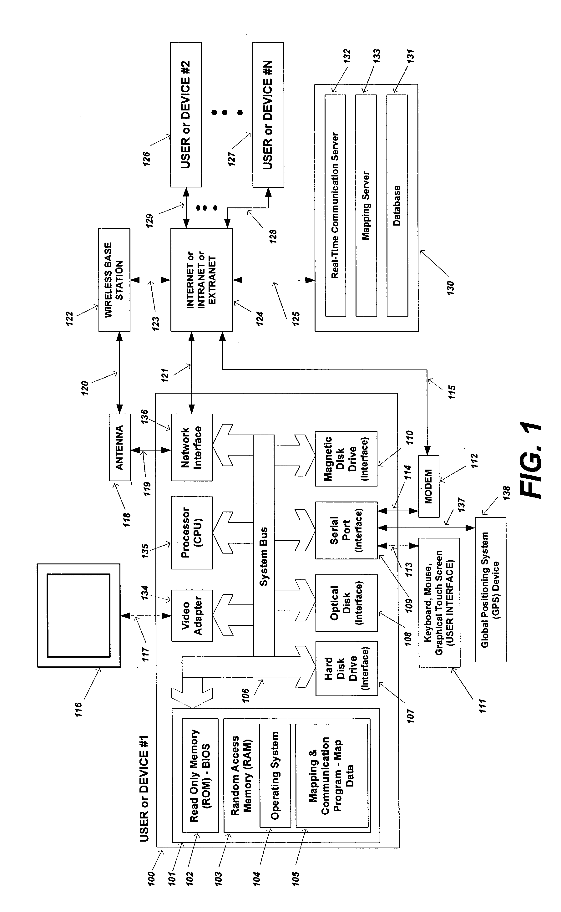
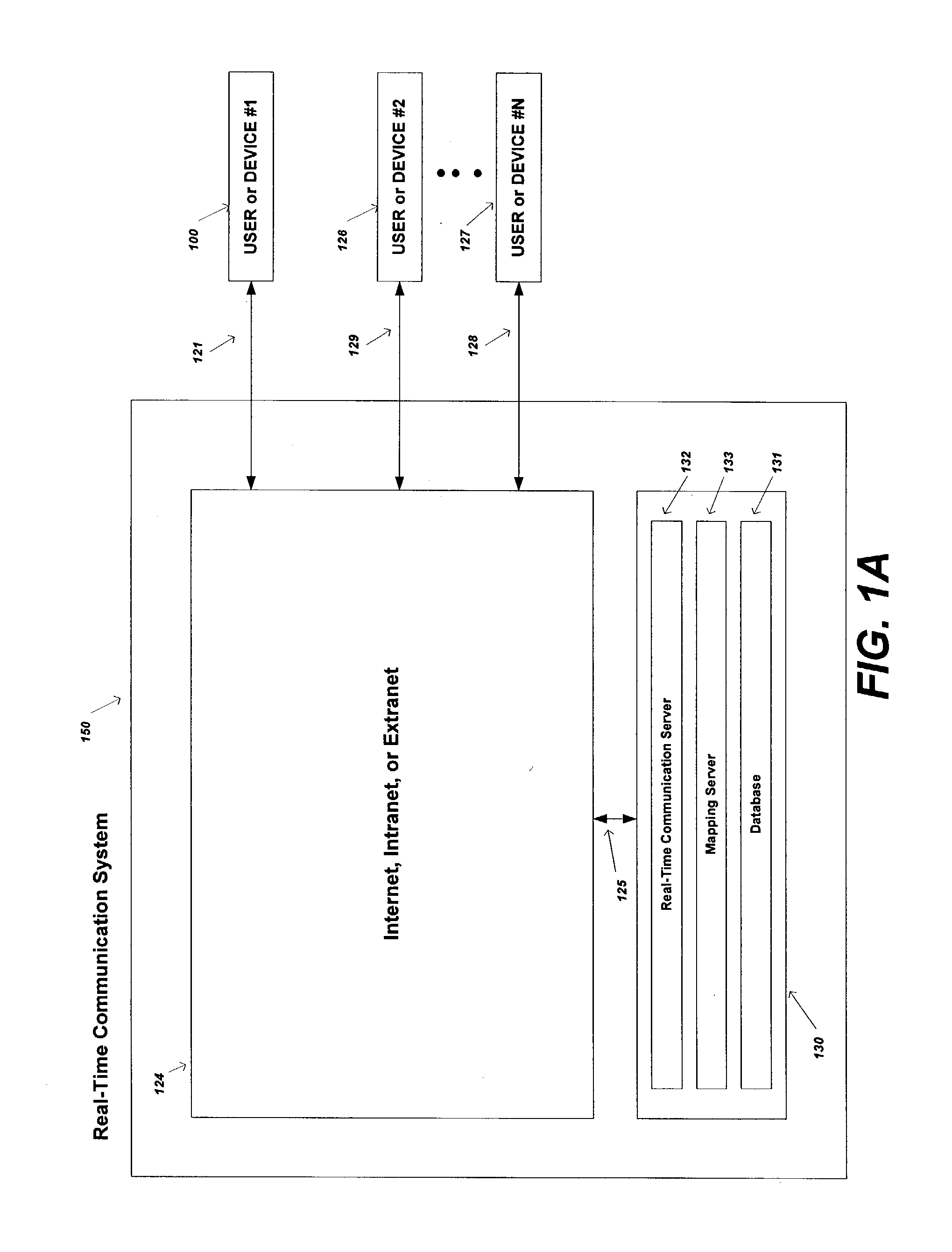
[0079] FIG. 1 illustrates a high-level diagram of one environment that is a suitable computing and networking environment in which the invention may be implemented. The invention will be described in the general context of an application that executes on an operating system in conjunction with a personal computer...


PUM


Abstract

The present invention is directed to a method and apparatus for sending and retrieving location relevant information to a user by selecting and designating a point of interest that is displayed on a graphical user interface and sending the location information associated with that point of interest to a receiver that is also selected using the graphical user interface. The location relevant information may also include mapped routes, waypoints, geo-fenced areas, moving vehicles etc. Updated location relevant information may also be continuously sent to the user while generating updated mapping information on the graphical user interface. The present invention may be practiced by using communication devices such as a personal computer, a personal digital assistance, in-vehicle navigation systems, or a mobile telephone.

Description

[0001] 1. Field of Invention[0002] This present invention relates to a computerized mapping and real-time communication software program, and more specifically, to integrating or coupling computerized mapping and real-time communication software for the purpose of transferring location-related information using a real-time communication system.[0003] 2. Description of the Related Art[0004] Computerized mapping and real-time communication software are independently achieving widespread use today. Such mapping programs are commonly used to automate tasks of calculating routes, viewing location-specific geographical areas for their spatial content, such as addresses, roadways, rivers, etc., and for the purpose of being used with Global Positioning System (GPS) devices for various applications, such as a personal navigation application. Mapping software programs apply to a wide variety of uses, such as personal navigation, telematics, thematic mapping, resource planning, routing, fleet ...

Claims


Application Information

Patent Timeline
IPC IPC(8): G01C21/20G01C21/36G06Q30/00G08G1/0962H04M1/72436
CPCG01C21/20G01C21/3438G01C21/3664G01C21/3679G01C21/3682G06Q30/02H04L65/403G08G1/096827G08G1/096844G08G1/096866G08G1/0969G06F3/04817G06F3/04892G08G1/0962H04L51/04G06F3/0486G06F3/0484H04M1/72436
Inventor SHEHA, MICHAEL A.SHEHA, ANGIEPETILLI, STEPHEN
Owner TELECOMM SYST INC
Why Eureka
Eureka Blog
Learn More