
Human-aided geo-rectification of geospatial metadata in video using a graphical interface

a geospatial metadata and graphical interface technology, applied in the field of human-aided georectification of geospatial metadata in video using a graphical interface, can solve the problems of confusion among decision makers, inaccurate sensor information from which the geospatial metadata is derived, and difficulty in accurately overlaying map information onto the underlying video feed, so as to maintain the accuracy of the geospatial metadata and less processing power

Active Publication Date: 2021-02-02
CUBIC CORPORATION
View PDF6 Cites 0 Cited by
  • Summary
  • Abstract
  • Description
  • Claims
  • Application Information

AI Technical Summary

Benefits of technology

This patent describes a way to make it easier for people to correct the information that shows where things are located in a video. It uses a user interface and tracking algorithms to quickly align the video with a map and make the video fit the map. This makes it faster and easier to fix mistakes in the video and can make it a cheaper option because it doesn't require as much computing power. The interface is simple and allows for real-time correction. Overall, this makes it easier for people to get the information they need when they watch videos.

Problems solved by technology

Accurately overlaying map information onto the underlying video feed can be difficult, however.
But the sensor information from which the geospatial metadata is derived may be inaccurate due to sensor miscalibration and / or other errors.
These errors can be reflected in the geospatial metadata and can ultimately lead to misalignment of the map information with the underlying video feed, which can cause confusion among decision makers viewing the combined visualization.

Method used


Image

  • Human-aided geo-rectification of geospatial metadata in video using a graphical interface
  • Human-aided geo-rectification of geospatial metadata in video using a graphical interface
  • Human-aided geo-rectification of geospatial metadata in video using a graphical interface

Examples


Embodiment Construction

[0019]The ensuing description provides embodiments only, and is not intended to limit the scope, applicability or configuration of the disclosure. Rather, the ensuing description of the embodiments will provide those skilled in the art with an enabling description for implementing an embodiment. It is understood that various changes may be made in the function and arrangement of elements without departing from the scope.

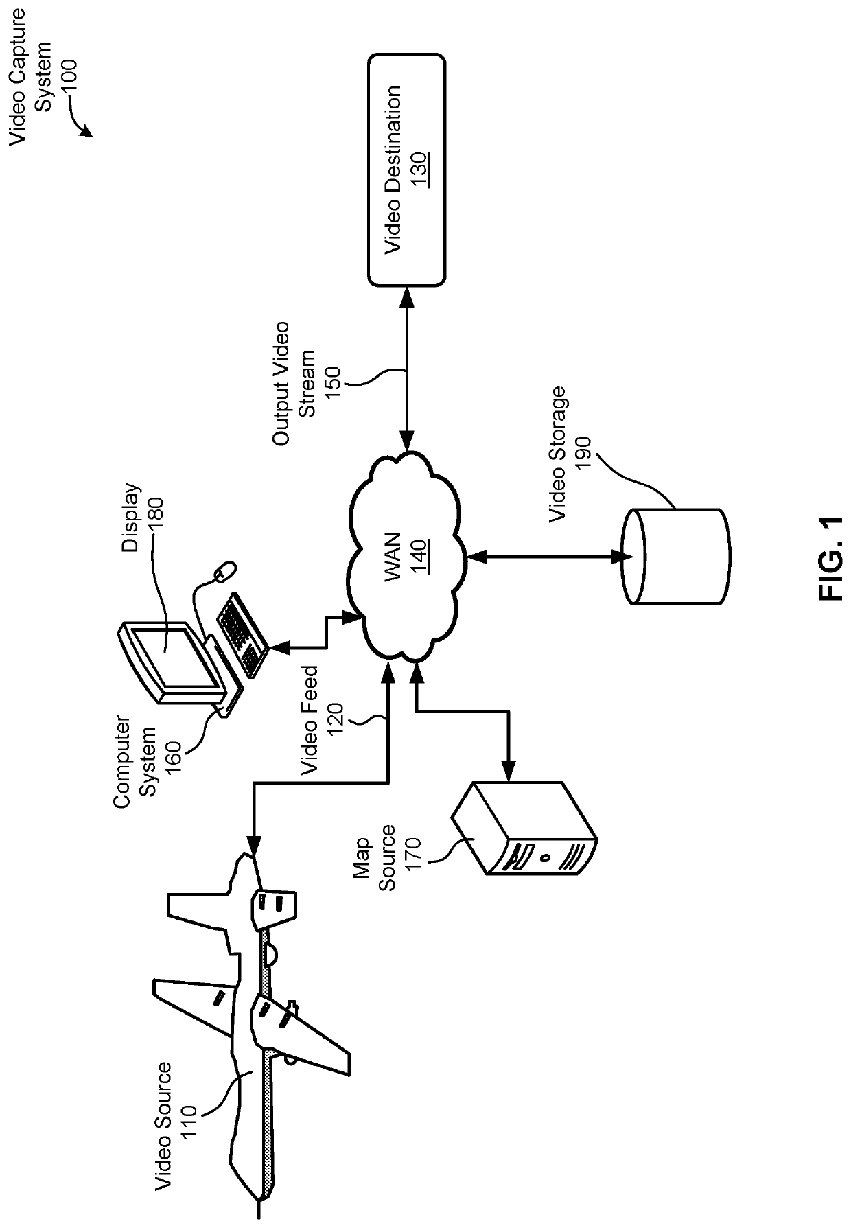
[0020]FIG. 1 is a simple diagram of a video capture system 100, according to an embodiment. Arrows represent communication links, which may be enabled using any of a variety of wireless and / or wired communication technologies. As will be appreciated, these technologies may communicate information in accordance with governing standards and / or protocol.

[0021]Here, a video source 110 may comprise a moving vehicle, such as an airplane, drone, or the like. Using a camera and other onboard electrical components, the video source 110 is able to capture video of the geograph...


PUM


Abstract

Embodiments disclosed herein provide a graphical user interface in which a user can quickly correct geospatial metadata accompanying a live video feed. More specifically, the graphical user interface can allow a user to quickly correlate one or more locations in the underlying video to one or more locations within the map data, thereby “anchoring” locations in the map data with locations in the video feed. These locations can then be used to correct the displayed alignment between the map information and video feed, as well as correct the geospatial metadata itself. Furthermore, tracking algorithms can be used to track the correlated locations, foregoing the need to provide manual correction for every frame of video.

Description

BACKGROUND[0001]Many military and civilian applications, such as governmental surveys or military surveillance, use video feeds in which map information is overlaid on a video stream of a geographical area. This can provide a viewer with an enhanced video comprising a combined visualization that can be critical in decision making. In real-time video streaming applications, for example, this can help decision makers quickly make accurate, informed decisions based on real-time events occurring at or near the geographical area captured in the video feed.[0002]Accurately overlaying map information onto the underlying video feed can be difficult, however. The video feed may be embedded with geospatial metadata used to determine how to overlay the map information with the underlying video stream. But the sensor information from which the geospatial metadata is derived may be inaccurate due to sensor miscalibration and / or other errors. These errors can be reflected in the geospatial metada...

Claims


Application Information

Patent Timeline
IPC IPC(8): G01C21/32G06K9/00
CPCG01C21/32G06K9/00637G06K9/00651G06K9/00671G01C21/3673G06V20/176G06V20/182G06V20/20G06V20/17
Inventor MARKOVIĆ, MILANĆIRKOVIĆ, ZORANGRUJIĆ, NEMANJABUSSERT, DILLON
Owner CUBIC CORPORATION
Learn More