
Unmanned aerial vehicle cluster collaborative flight path planning method considering communication time delay

A track planning and unmanned aerial vehicle technology, applied in three-dimensional position/course control, data processing application, prediction, etc., to achieve the effect of ensuring reliability, ensuring timeliness, and reducing planning complexity

Pending Publication Date: 2022-07-26
BEIJING INSTITUTE OF TECHNOLOGYGY
View PDF0 Cites 4 Cited by
  • Summary
  • Abstract
  • Description
  • Claims
  • Application Information

AI Technical Summary

Problems solved by technology

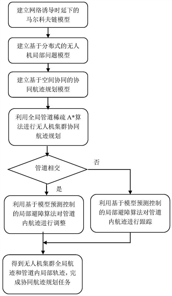
[0005] The present invention discloses a UAV cluster cooperative track planning method considering communication delay, aiming at the communication delay problem of the UAV cluster in complex application scenarios, establishing a communication network delay model and a collaborative track planning model

Method used


Image

  • Unmanned aerial vehicle cluster collaborative flight path planning method considering communication time delay
  • Unmanned aerial vehicle cluster collaborative flight path planning method considering communication time delay
  • Unmanned aerial vehicle cluster collaborative flight path planning method considering communication time delay

Examples


Embodiment 1

[0117] The simulation hardware is Intel Core i5-6200 CPU 2.30GHz, 8G memory, and the simulation environment is MATLABR2021b. UAV formations perform tasks in a two-dimensional environment of 22000m × 11500m. The safe distance between drones is set to 200m, and the safe distance between drones and obstacles is 200m.

[0118] like figure 1 As shown, the present embodiment discloses a coordinated trajectory planning method for a swarm of unmanned aerial vehicles that considers communication delay, and the specific implementation steps are as follows:

[0119] Step 1: Obtain UAV flight performance parameter information, track constraint information and mission environment information.

[0120] Set the flight speed of the UAV as 100m / s, the overload as 10g, the maximum turn angle as 45°, and the minimum track segment length l min =1500m. The starting point / end position of the UAV and the position and radius of the no-fly zone in the mission environment are listed in Table 1.

...


PUM


Abstract

The invention discloses an unmanned aerial vehicle cluster collaborative flight path planning method considering communication time delay, and belongs to the technical field of flight path planning. Under the condition of considering communication time delay, a'global planning-local obstacle avoidance 'cooperative track planning framework is constructed, in the global planning stage, probability distribution of adjacent unmanned aerial vehicle positions caused by random communication time delay is considered, the probability distribution situation of the adjacent unmanned aerial vehicle positions caused by the communication time delay is combined into a sparse A * search algorithm, and the probability distribution situation of the adjacent unmanned aerial vehicle positions caused by the random communication time delay is combined into the sparse A * search algorithm. A priority decoupling mechanism is introduced to improve the algorithm search efficiency; in the local collision avoidance stage, the local collision risk still exists in the global flight path due to the uncertainty of communication time delay and the uncertainty of the position of an adjacent vehicle is considered, the optimal control problem of distributed model predictive control is solved, and flight path tracking and local adjustment of the unmanned aerial vehicle in the pipeline are achieved. Based on double-level cooperative flight path planning, the timeliness and reliability of unmanned aerial vehicle cluster cooperative flight path planning under communication time delay are ensured, and the cooperative capability of an unmanned aerial vehicle cluster in a real scene is improved.

Description

technical field [0001] The invention discloses a coordinated trajectory planning method for an unmanned aerial vehicle swarm considering communication delay, and belongs to the technical field of trajectory planning. Background technique [0002] Collaborative trajectory planning is one of the key technologies to achieve autonomous coordination of UAV swarms. It designs a satisfactory or optimal coordinated flight by considering factors such as space-time consistency constraints, UAV performance constraints, flight mission constraints, terrain, and threats. Track, guide the UAV swarm to complete the given cooperative flight task. However, in practical application scenarios, due to electromagnetic interference and frequent task adjustment, it is difficult for UAV swarms to ensure high-speed and reliable communication data transmission. Communication delay is a common non-ideal communication situation. The high delay characteristic of information interaction makes it difficul...

Claims


Application Information

Patent Timeline
Patent Type & Authority Applications(China)
IPC IPC(8): G05D1/10G06Q10/04G06N7/00
CPCG05D1/104G06Q10/047G06N7/01
Inventor 龙腾李承恩孙景亮李俊志王仰杰
Owner BEIJING INSTITUTE OF TECHNOLOGYGY
Learn More