Planar laser SLAM and navigation method based on compressed three-dimensional space point cloud

A plane laser, three-dimensional space technology, applied in two-dimensional position/channel control, image data processing, instruments, etc., can solve the problems of high real-time performance and low calculation amount of plane laser SLAM, so as to improve accuracy and improve obstacles. The effect of recognition ability and safety improvement

Pending Publication Date: 2022-04-29
CHINA AGRI UNIV
View PDF0 Cites 0 Cited by
  • Summary
  • Abstract
  • Description
  • Claims
  • Application Information

AI Technical Summary

Problems solved by technology

Outdoor scenes such as orchards have the characteristics of obvious three-dimensional structure features, open environment, and complex obstacles. The traditional indoor planar SLAM technology that only relies on planar lidar is not suitable, but planar laser SLAM has the characteristics of low computation and high real-time performance.

Method used


Image

  • Planar laser SLAM and navigation method based on compressed three-dimensional space point cloud
  • Planar laser SLAM and navigation method based on compressed three-dimensional space point cloud
  • Planar laser SLAM and navigation method based on compressed three-dimensional space point cloud

Examples


Embodiment Construction

[0042] The present invention will be further described below in conjunction with the accompanying drawings and embodiments.

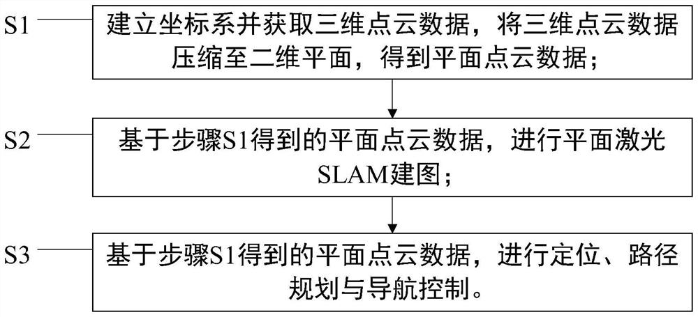
[0043] Such as figure 1 As shown, a kind of planar laser SLAM and navigation method based on compressed three-dimensional space point cloud of the present invention comprises the following steps:

[0044] S1. Establish a coordinate system and obtain 3D point cloud data, compress the 3D point cloud data to a 2D plane, and obtain plane point cloud data;

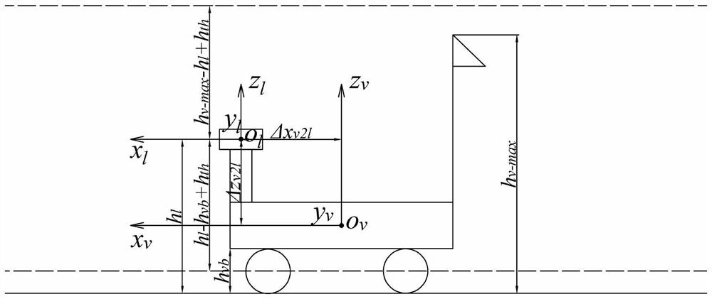
[0045] S1.1 Establish the mobile robot coordinate system {v} and the lidar coordinate system {l} to obtain basic data;

[0046] Such as figure 2 As shown, take the center of the main body of the mobile robot as the origin o v , x v The axis points to the front of the mobile robot, y v axis parallel to the wheel axis pointing to the left, z v The axis points vertically upwards to establish a mobile robot coordinate system that satisfies the right-hand rule o v x v the y v z v , recorded as {v}....


PUM


Abstract

The planar laser SLAM and navigation method comprises the following steps: establishing a coordinate system, acquiring three-dimensional point cloud data, and compressing the three-dimensional point cloud data to a two-dimensional plane to obtain planar point cloud data; and based on the plane point cloud data, performing plane laser SLAM mapping and positioning, path planning and navigation control. Point cloud information of an operation environment is collected through a three-dimensional laser radar, a three-dimensional laser point cloud is compressed to a two-dimensional plane in combination with three-dimensional geometric dimension constraints of a mobile robot, a plane point cloud containing three-dimensional space information is obtained, the plane point cloud serves as original point cloud data of a plane laser SLAM algorithm, plane SLAM mapping of outdoor scenes such as an orchard is achieved, and the three-dimensional laser SLAM mapping method is applied to outdoor scenes such as an orchard. A global path planned by using the map is a safe and feasible path, and the plane point cloud is used as original point cloud data of a navigation control algorithm, so that real-time positioning of the mobile robot in the map and real-time obstacle detection and obstacle avoidance in the path tracking process are realized.

Description

technical field [0001] The invention belongs to the technical field of laser SLAM mapping and navigation, and in particular relates to a SLAM mapping and navigation method suitable for outdoor scenes such as orchards. Background technique [0002] At the same time, Simultaneous Localization and Mapping (SLAM) is a key technology for mobile robots to locate and map in an unknown environment, and it also provides core support for all future automation technologies (such as smart agriculture and unmanned farms). [0003] At present, indoor planar laser SLAM technology based on planar laser radar is relatively mature, and has been widely used in sweeping robots, storage robots, service robots and other fields. Outdoor scenes such as orchards have the characteristics of obvious three-dimensional structural features, open environment, and complex obstacles. The traditional indoor planar SLAM technology that only relies on planar lidar is not suitable for it. However, planar laser ...

Claims


Application Information

Patent Timeline
IPC IPC(8): G05D1/02G06T7/73
CPCG05D1/024G05D1/0214G05D1/0276G06T7/73G06T2207/10028
Inventor 郑永军刘伟洪李文伟许家伟苏道毕力格刘星星王子蒙
Owner CHINA AGRI UNIV
Why Eureka
Try Eureka