Three-dimensional identification method of landslide slip surface based on unmanned aerial vehicle image and deep learning

A deep learning and three-dimensional recognition technology, which is applied in three-dimensional object recognition, neural learning methods, character and pattern recognition, etc., can solve problems such as inaccurate positioning of sliding surfaces, and achieve the effect of avoiding complex calculations

Pending Publication Date: 2022-03-01
HARBIN INST OF TECH
View PDF0 Cites 2 Cited by
  • Summary
  • Abstract
  • Description
  • Claims
  • Application Information

AI Technical Summary

Problems solved by technology

[0003] The present invention is to solve the problem that the specific positioning of the slip surface is inaccurate in the existing method for detecting landslides, and now provides a three-dimensional recognition method for landslide slip surfaces based on UAV images and deep learning

Method used


Image

  • Three-dimensional identification method of landslide slip surface based on unmanned aerial vehicle image and deep learning
  • Three-dimensional identification method of landslide slip surface based on unmanned aerial vehicle image and deep learning
  • Three-dimensional identification method of landslide slip surface based on unmanned aerial vehicle image and deep learning

Examples


specific Embodiment approach 1

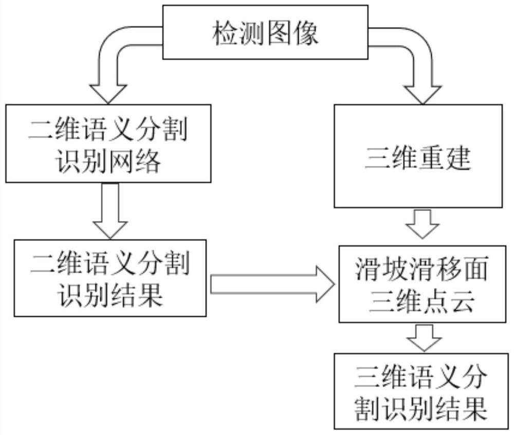
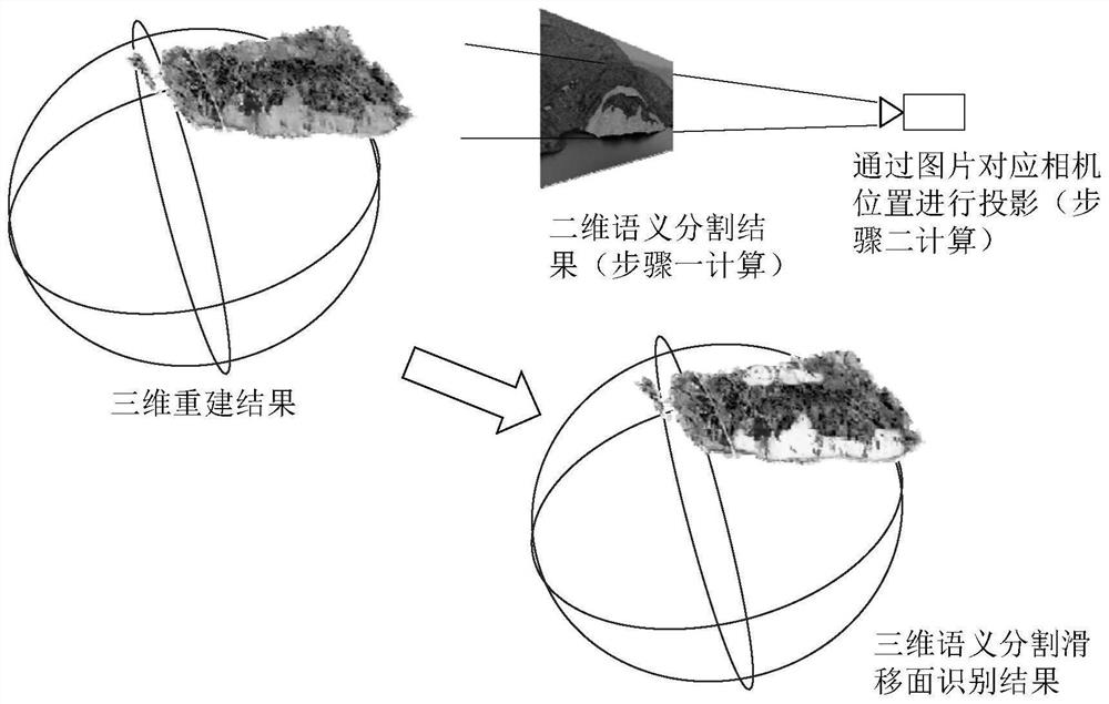
[0053] Specific implementation mode one: refer to Figure 1 to Figure 3 Specifically illustrate the present embodiment, the three-dimensional recognition method of the landslide slip surface based on the UAV image and deep learning described in the present embodiment includes the following steps:

[0054] Step 1: Set up the camera on the UAV, and use the UAV to collect images from at least 5 different angles of the measured area as detection images. Among them, the camera changes a pose every time an image is taken.

[0055] Step 2: First establish the semantic segmentation network, and then use the deep learning method to train the semantic segmentation network. The training method is:

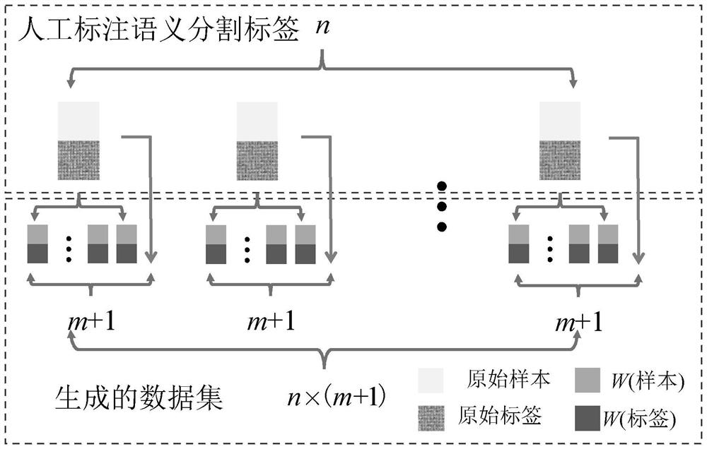
[0056] First of all, the training method of deep learning requires a training data set input and output by the network. In this embodiment, a random deformation method is used to generate the training data set. Specifically, randomly select n images from all the detection images obtained by...

specific Embodiment

[0090] In this embodiment, the real UAV aerial image of the Hemenkou landslide is used as the input image to complete the three-dimensional semantic segmentation and recognition of the landslide sliding surface in this area.

[0091] According to manual measurement, the overall front edge width of the Hemenkou landslide is 366m, and the longitudinal length is 932m. The plane area is 298,500 square meters, and the secondary deformation body at the front edge of the landslide: the width of the front edge is 366m, and the longitudinal length is 240m. The floor area is 67,700 square meters. The total volume is 6 million cubic meters, and the average thickness of the secondary sliding body is 30m, which is about 2.5 million cubic meters. In this embodiment, the algorithm provided by the present invention is used to identify the three-dimensional semantic segmentation of the Hemenkou landslide.

[0092] Through the random deformation method of the slip surface, the two-dimensional...


PUM


Abstract

The invention discloses a three-dimensional identification method of a landslide slip surface based on unmanned aerial vehicle images and deep learning, and relates to the technical field of disaster monitoring. The objective of the invention is to solve the problem of inaccurate specific positioning of a slip plane in the existing landslide detection method. According to the method, an unmanned aerial vehicle is used for collecting images of at least five different angles of a detected area as detection images, a semantic segmentation network is used for distinguishing types of all pixel points in the detection images, a semantic segmentation result is obtained, the types of the pixel points comprise background pixel points and landslide slip plane pixel points, and the types of the pixel points comprise background pixel points and landslide slip plane pixel points. Reconstructing the detection image by using a three-dimensional reconstruction algorithm to obtain a three-dimensional point cloud containing a landslide slip plane, calculating a two-dimensional coordinate of any pixel point A in the three-dimensional point cloud in a two-dimensional plane, substituting the two-dimensional coordinate of the pixel point A in the two-dimensional plane into the semantic segmentation result obtained in the step 2 to obtain the type of the pixel point A, and obtaining the type of the pixel point A; and taking the type of the pixel point A and the three-dimensional coordinate of the pixel point A as a three-dimensional identification result of the landslide slip plane.

Description

technical field [0001] The invention belongs to the technical field of disaster monitoring, in particular to the monitoring of landslide sliding surfaces. Background technique [0002] The monitoring of natural disasters is of great significance to the early warning and prevention of natural disasters. Timely detection of natural disaster signs and the expansion of natural disaster signs plays an indispensable role in preventing human and financial losses and protecting the ecological environment. In natural disasters, landslides will not only destroy surface vegetation, cause water and soil erosion, destroy natural ecosystems, and even destroy artificial infrastructure, causing casualties. In the traditional discipline of natural disasters and prevention, in addition to manual field inspections, a combination of fixed camera shooting and manual inspection of photos is generally used. This method requires a lot of labor and time, and is prone to misjudgments and missed jud...

Claims


Application Information

Patent Timeline
Patent Type & Authority Applications(China)
IPC IPC(8): G06V20/10G06V20/64G06V10/75G06V10/82G06V10/774G06K9/62G06N3/04G06N3/08
CPCG06N3/08G06N3/045G06F18/214
Inventor 李惠赵今周文松
Owner HARBIN INST OF TECH
Why Eureka
Try Eureka