Radar calibration method and device, electronic equipment and storage medium

A calibration method and radar technology, applied in the field of radar, can solve the problems of low accuracy of calibration results, manual calibration, and inability to guarantee real-time synchronization of the road environment.

Pending Publication Date: 2021-11-26
GUANGZHOU WERIDE TECH LTD CO
View PDF0 Cites 0 Cited by
  • Summary
  • Abstract
  • Description
  • Claims
  • Application Information

AI Technical Summary

Problems solved by technology

[0006] Embodiments of the present invention provide a radar calibration method, device, electronic equipment, and storage medium to solve the problem that existing roadside radar calibration methods rely on point cloud high-precision maps for registration, and point cloud high-precision maps cannot guarantee real-time synchronization of road environments. Changes, and the low accuracy of the calibration results obtained through the registration of single-frame point clouds and point cloud high-precision maps requires manual calibration

Method used


Image

  • Radar calibration method and device, electronic equipment and storage medium
  • Radar calibration method and device, electronic equipment and storage medium
  • Radar calibration method and device, electronic equipment and storage medium

Examples


Embodiment 1

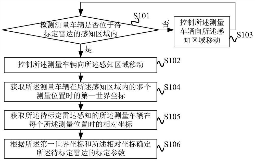
[0034] figure 1 It is a flowchart of a radar calibration method provided by Embodiment 1 of the present invention. This embodiment is applicable to the situation of calibrating roadside radars. The method can be executed by a radar calibration device, which can be implemented by software and / or hardware implementation, which can be configured in an electronic device, for example, can be configured in a server. The method specifically includes the following steps:

[0035] S101. Detect whether the measuring vehicle is located in the sensing area of ​​the radar to be calibrated.

[0036] In the embodiment of the present invention, the measurement vehicle may be an unmanned road test vehicle, and various sensors may be installed on the measurement vehicle, for example, sensors such as radar, camera, and positioning module may be installed. The radar to be calibrated can be the roadside lidar that needs to be calibrated. The need for calibration can mean that the roadside lidar ...

Embodiment 2

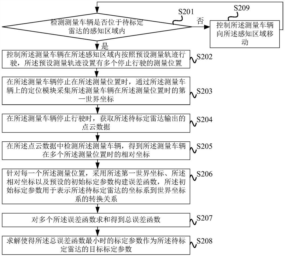
[0050] figure 2 It is a flowchart of a radar calibration method provided by Embodiment 2 of the present invention. This embodiment is optimized on the basis of the foregoing Embodiment 1. The method specifically includes the following steps:

[0051] S201. Detect whether the measuring vehicle is located in the sensing area of ​​the radar to be calibrated.

[0052] Specifically, the measurement vehicle can be an unmanned road test vehicle, the radar to be calibrated can output point cloud data according to a preset frequency, and when the measurement vehicle is identified from the point cloud data, it is determined that the measurement vehicle is located in the sensing area of ​​the radar to be calibrated In one example, a detection model for identifying and measuring vehicles can be trained in advance, and the point cloud data output by the radar to be calibrated is input into the detection model to obtain the detection result. If the detection result is that the measuring ve...

Embodiment 3

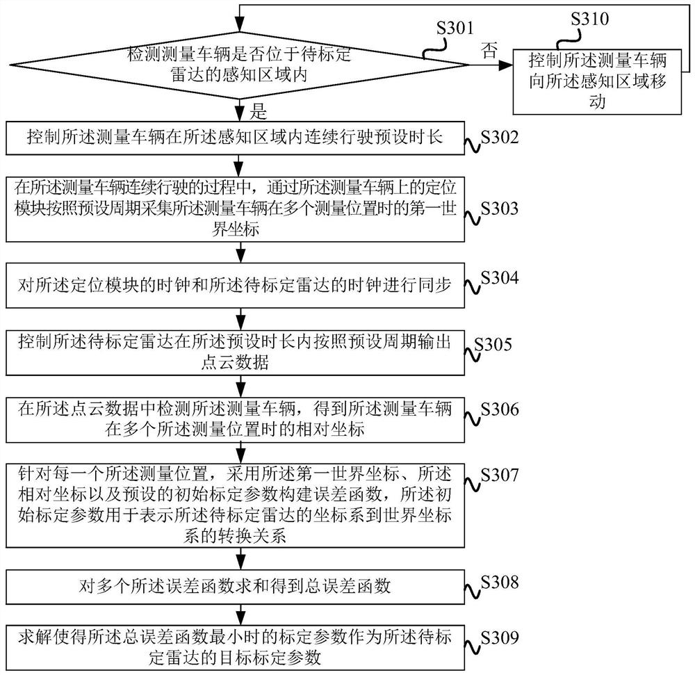
[0081] image 3 It is a flowchart of a radar calibration method provided by Embodiment 3 of the present invention. This embodiment is optimized on the basis of the foregoing embodiments. The method specifically includes the following steps:

[0082] S301. Detect whether the measuring vehicle is located in the sensing area of ​​the radar to be calibrated.

[0083] Specifically, the measurement vehicle can be an unmanned road test vehicle, the radar to be calibrated can output point cloud data according to a preset frequency, and when the measurement vehicle is identified from the point cloud data, it is determined that the measurement vehicle is located in the sensing area of ​​the radar to be calibrated In one example, a detection model for identifying and measuring vehicles can be trained in advance, and the point cloud data output by the radar to be calibrated is input into the detection model to obtain the detection result. If the detection result is that the measuring vehi...


PUM


Abstract

The embodiment of the invention discloses a radar calibration method and device, electronic equipment and a storage medium. The radar calibration method comprises the steps that whether a measurement vehicle is located in a sensing area of a to-be-calibrated radar or not is detected; if yes, the measurement vehicle is controlled to run in the sensing area according to a preset mode; if not, the measurement vehicle is controlled to move towards the sensing area, and when the measurement vehicle runs in the sensing area according to a preset mode, first world coordinates of the measurement vehicle at multiple measurement positions in the sensing area are obtained; relative coordinates of the measurement vehicle sensed by the to-be-calibrated radar at each measurement position is obtained; and the calibration parameters of the to-be-calibrated radar are determined according to the first world coordinates and the relative coordinates, a point cloud high-precision map does not need to be collected, registration of the point cloud sensed by the roadside radar and the point cloud high-precision map is not needed, and the world coordinates and the relative coordinates of the measurement vehicle can be automatically obtained to solve the calibration parameters of the roadside radar. Therefore, accurate calibration of the roadside radar without manual intervention is realized.

Description

technical field [0001] The embodiments of the present invention relate to the technical field of radar, and in particular to a radar calibration method, device, electronic equipment and storage medium. Background technique [0002] The development of unmanned driving technology depends on the precise perception of unmanned vehicles. Lidar is widely used in unmanned vehicles due to its real-time modeling capabilities for the environment to give unmanned vehicles the ability to perceive, while in intelligent transportation At the road end of the field, roadside lidar is also used to perceive and observe the covered roads to achieve vehicle-road coordination. [0003] After the roadside lidar is installed, it is necessary to calibrate the pose of the roadside lidar in the world coordinate system, or to re-calibrate regularly after installation and calibration to ensure the accuracy of the pose. The existing calibration method is to cover the lidar Establish a point cloud high-...

Claims


Application Information

Patent Timeline
Patent Type & Authority Applications(China)
IPC IPC(8): G01S7/497
CPCG01S7/497
Inventor 桑远超王睿杨庆雄韩旭
Owner GUANGZHOU WERIDE TECH LTD CO
Why Eureka
Try Eureka