
Three-dimensional visualization and rapid mapping method and model for emergency plan for small watershed natural disasters

A technology for natural disasters and emergency plans, applied in 3D modeling, image data processing, climate change adaptation, etc., to solve problems such as inability to monitor and prevent natural disasters, and inability to provide emergency plans.

Pending Publication Date: 2021-10-26
浙江点创信息科技有限公司
View PDF1 Cites 2 Cited by
  • Summary
  • Abstract
  • Description
  • Claims
  • Application Information

AI Technical Summary

Problems solved by technology

[0005] The purpose of the present invention is to provide a method and model for three-dimensional visualization and rapid mapping of emergency plans for natural disasters in small watersheds, so as to solve the problem that existing rapid mapping cannot monitor and prevent natural disasters, and cannot provide emergency plans question

Method used


Image

  • Three-dimensional visualization and rapid mapping method and model for emergency plan for small watershed natural disasters
  • Three-dimensional visualization and rapid mapping method and model for emergency plan for small watershed natural disasters

Examples


Embodiment Construction

[0049] The method and model for three-dimensional visualization and rapid drawing of emergency plans for natural disasters in small watersheds proposed by the present invention will be further described in detail below in conjunction with the accompanying drawings and specific embodiments. It should be noted that all the drawings are in a very simplified form and use imprecise scales, and are only used to facilitate and clearly assist the purpose of illustrating the embodiments of the present invention. In addition, the structures shown in the drawings are often a part of the actual structures. In particular, each drawing needs to display different emphases, and sometimes uses different scales.

[0050] It should be noted that the terms "comprising" and "having" and any variations thereof in the specification, claims and description of the drawings of the present invention are intended to cover non-exclusive inclusion, for example, including a series of steps or units A proce...


PUM


Abstract

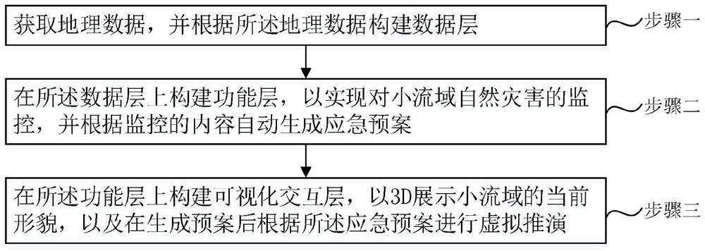
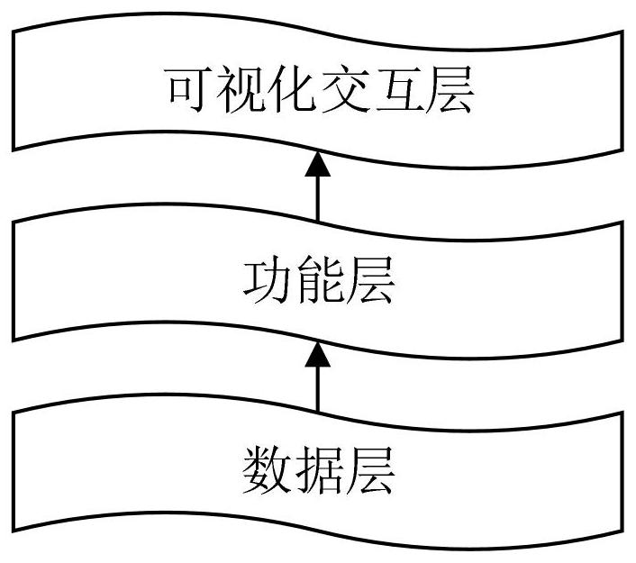
The invention provides a three-dimensional visualization and rapid mapping method and model for an emergency plan for small watershed natural disasters, and the method comprises the steps: obtaining geographic data, and constructing a data layer according to the geographic data; constructing a functional layer on the data layer to monitor natural disasters in the small watershed, and automatically generating an emergency plan according to the monitored content; and constructing a visual interaction layer on the functional layer to display the current morphology of the small watershed in a 3D manner, and performing virtual deduction according to an emergency plan after the plan is generated. The small watershed is monitored in real time, and an emergency plan is automatically generated, so that the prevention of natural disasters in the small watershed is more active; through the visual interaction layer, the current morphology of the small watershed can be displayed in a 3D mode, and virtual deduction of an emergency plan is carried out, so that people can visually confirm whether loss caused by natural disasters is matched with the emergency plan or not, and the problems that existing rapid mapping cannot monitor and prevent the natural disasters and cannot provide the emergency plan are solved.

Description

technical field [0001] The invention relates to the technical field of disaster prevention and control, in particular to a method and model for three-dimensional visualization and rapid drawing of emergency plans for natural disasters in small watersheds. Background technique [0002] Natural disasters in China are diverse, widely distributed, high in frequency and high in intensity, often causing huge losses. It is of great significance to ensure the safety of people's lives and property by timely and efficiently grasping the disaster situation and scientifically and effectively preventing and reducing disasters. In the emergency response to emergencies and disaster prevention and mitigation, surveying and mapping geographic information plays an indispensable role. One of the core tasks of emergency surveying and mapping support is to provide efficient and orderly map production services for public emergencies. [0003] Disaster prevention and mitigation work puts forwar...

Claims


Application Information

Patent Timeline
IPC IPC(8): G06T17/05G06K9/62G06Q50/26
CPCG06T17/05G06Q50/26G06F18/22G06F18/241Y02A10/40
Inventor 宋俊锋叶振朱媛曾海勇刘伟峰
Owner 浙江点创信息科技有限公司
Learn More