
Method for compiling sedimentary microfacies paleogeographic map in continental sedimentary basin

A technology of sedimentary microfacies and facies deposition, applied in the field of paleogeographical mapping, can solve problems such as ineffective mapping, insufficient basis for microfacies division, and lack of focus

Pending Publication Date: 2021-09-14
青海省地质调查院青海省地质矿产研究院青海省地质遥感中心
View PDF1 Cites 0 Cited by
  • Summary
  • Abstract
  • Description
  • Claims
  • Application Information

AI Technical Summary

Problems solved by technology

[0004] However, using the above-mentioned single map compilation method, the representation of the sedimentary microfacies of salt lakes in continental basins after the map is not accurate, such as insufficient basis for the division of microfacies, rough distribution in the horizontal direction of the map, and lack of emphasis Prominent, the map compilation effect is not obvious, what is important is that the prospect evaluation and exploration guidance of salt lake mineral resources in continental basins are not strong

Method used


Image

  • Method for compiling sedimentary microfacies paleogeographic map in continental sedimentary basin
  • Method for compiling sedimentary microfacies paleogeographic map in continental sedimentary basin
  • Method for compiling sedimentary microfacies paleogeographic map in continental sedimentary basin

Examples


Embodiment 1

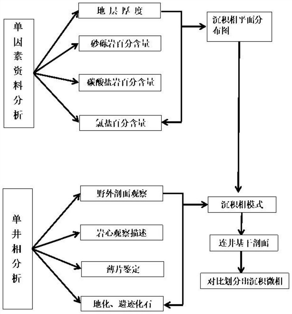
[0041] Embodiment 1 of the present invention provides a method for compiling a sedimentary microfacies palaeogeography map in a continental sedimentary basin, comprising the following steps:

[0042](1) Select single-factor parameters; among them, single-factor parameters include single-factor thickness and single-factor percentage, single-factor thickness includes stratum thickness and sedimentary thickness; single-factor percentage includes glutenite percentage, dark mudstone percentage, and carbonate rock percentage and percentage of chloride salt;

[0043] (2) Separately prepare single-factor thickness contour maps and single-factor percentage contour maps

[0044] (21) Compilation of single-factor thickness contour maps: collect drilling profile data in the study area, comprehensively analyze, sort out the single-factor thickness of each profile in the study area in different periods and in different sections, and list them into thickness data tables, thickness data The ...

Embodiment 2

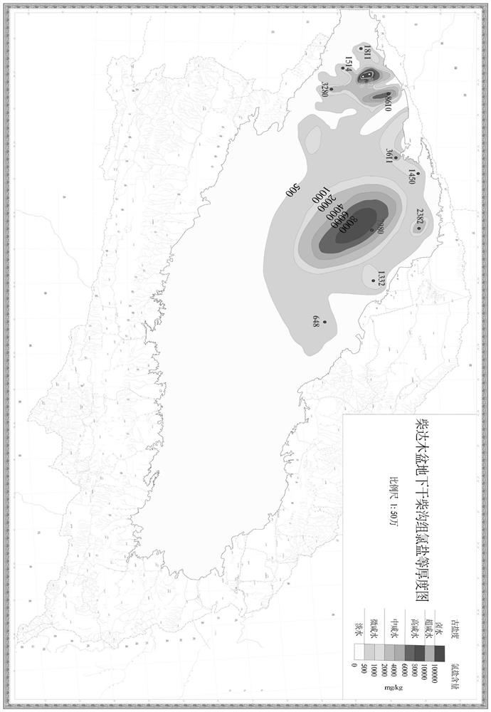
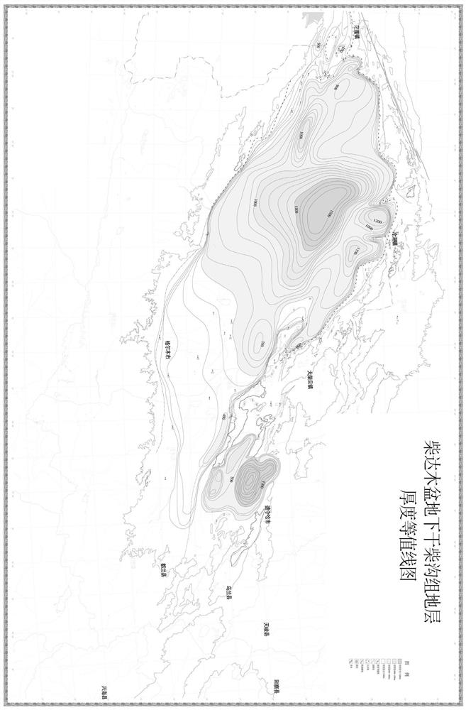
[0051] Embodiment 2 of the present invention provides a method for compiling a sedimentary microfacies paleogeographic map in a continental sedimentary basin, taking the Qaidam Basin as an example, specifically comprising the following steps:

[0052] (1) Collect Cenozoic drilling data in the Qaidam Basin, and determine after analysis that the single factor parameters include stratum thickness, percentage content of glutenite, percentage content of carbonate rock, percentage content of dark mudstone, and percentage content of chloride salt;

[0053] (2) Obtained the results of stratum thickness, glutenite percentage content, carbonate rock percentage content, and chloride salt percentage content from the drill core observation and description analysis, and subdivided the Cenozoic of the Qaidam Basin into Lulehe Formation, Lower Ganchaigou Formation, Upper Ganchaigou Formation, Lower Youshashan Formation, Upper Youshashan Formation, Shizigou Formation, Alar Formation, Gasikule F...


PUM


Abstract

The invention discloses a method for compiling a sedimentary microfacies paleogeographic map in a continental sedimentary basin. The method comprises the following steps of: (1) selecting single-factor parameters; (2) compiling a single-factor thickness contour map and a single-factor percentage contour map; (3) performing single-well phase analysis on a research area, and drawing a single-well-facies analysis histogram; and (4) comprehensively compiling a sedimentary microfacies paleogeography map in a continental sedimentary basin according to the single-factor thickness contour map, the single-factor percentage contour map and a sedimentary facies distribution map. According to the method, 'single-factor analysis and multi-factor comprehensive mapping' is combined with 'single-well facies analysis', so that the compiled paleogeographic map is more accurate in expression of sedimentary microfacies, especially accurate in expression of salt lake facies in continental sedimentary basins, and the method has great significance in research of the salt lake facies in the continental sedimentary basins.

Description

technical field [0001] The invention relates to the technical field of paleogeographic map compilation, in particular to a method for compiling sedimentary microfacies paleogeographic maps in continental sedimentary basins. Background technique [0002] At present, the purpose of lithofacies palaeogeography research is to analyze sedimentary facies, and specifically analyze the sum of all primary sedimentary features in the sedimentary environment (such as rocks, paleontology, rock geochemistry, paleoflow, provenance, etc.). Based on the division of sedimentary types and sedimentary facies, the content is specifically expressed in maps by means of map compilation, and the relationship with the mineralization process of saline lake facies is studied. For the perspective prediction and evaluation of saline lake mineral resources in continental basins and the practice of exploration and development is of great significance. [0003] At present, the lithofacies palaeogeography ...

Claims


Application Information

Patent Timeline
Patent Type & Authority Applications(China)
IPC IPC(8): G01V1/50G01V1/40G01V1/30
CPCG01V1/50G01V1/40G01V1/301G01V1/307Y02A90/10
Inventor 张金明付彦文薛万文康继祖王涛李五福
Owner 青海省地质调查院青海省地质矿产研究院青海省地质遥感中心
Learn More