
Terrain shielding radar detection range calculation method based on three-dimensional grid

A technology of detection range and calculation method, which is applied in the field of radar detection range calculation based on three-dimensional grid terrain occlusion, can solve the problem that terrain occlusion cannot be considered in the modeling of radar detection area, so as to improve the scale of grid calculation and solve the problem of large amount of data , the effect of improving efficiency

Active Publication Date: 2021-08-17
中国人民解放军军事科学院战争研究院
View PDF2 Cites 4 Cited by
  • Summary
  • Abstract
  • Description
  • Claims
  • Application Information

AI Technical Summary

Problems solved by technology

[0006] This invention proposes a three-dimensional grid-based terrain occlusion radar detection range calculation method to solve the problem that the terrain cannot be considered in radar detection area modeling under the existing three-dimensional grid conditions Technical problems with occlusion

Method used


Image

  • Terrain shielding radar detection range calculation method based on three-dimensional grid
  • Terrain shielding radar detection range calculation method based on three-dimensional grid
  • Terrain shielding radar detection range calculation method based on three-dimensional grid

Examples


Embodiment Construction

[0042] In order to make the purpose, content and advantages of the present invention clearer, the specific implementation manners of the present invention will be further described in detail below in conjunction with the accompanying drawings and embodiments.

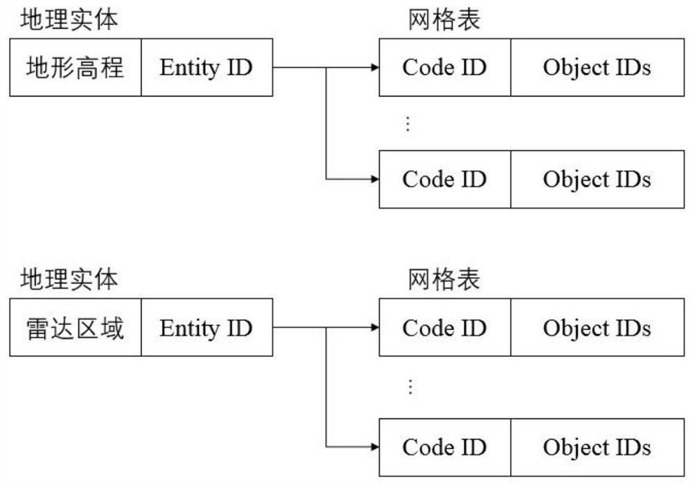
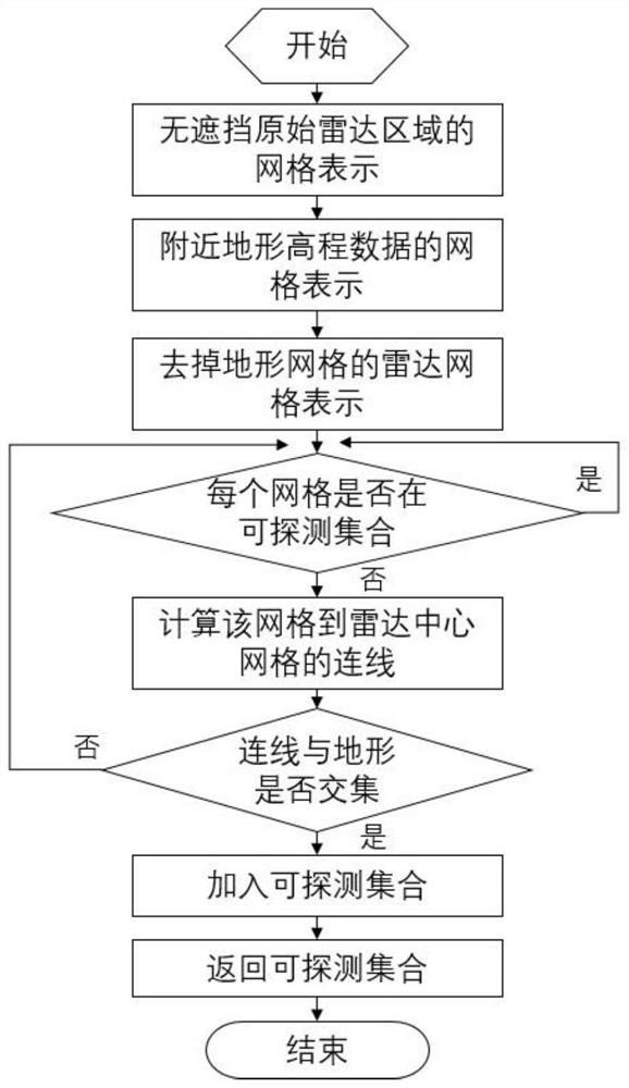
[0043] The present invention proposes a method for calculating the detection range of terrain occlusion radar based on a three-dimensional grid, using the GeoSOT-3D encoding method to divide the space into three-dimensional grids for encoding, and storing the discreteness of the radar and terrain through the data mode of the disordered hash table The grid set allows it to quickly perform set intersection and difference operations; then perform line-of-sight-based occlusion calculations for the radar area excluding the basic terrain, and apply accelerated calculation methods to quickly reduce the number of iterations to achieve fast calculation results. The main process is as figure 1 As shown, it specifically includes t...


PUM


Abstract

The invention provides a terrain occlusion radar detection range calculation method based on a three-dimensional grid, and the calculation of the radar detection range under the influence of the terrain is realized through the steps of calculating a difference set of a coding set, calculating intervisibility based on the grid and the like on the basis of a three-dimensional grid expression structure. According to the invention, the terrain data and the radar detection range are unified into discrete grids for storage based on the three-dimensional grids, and whether a certain grid in the radar detection grids is shielded by the terrain is judged through the intervisibility calculation idea, so that the reasonable and correct three-dimensional expression of the radar detection area can be achieved; the error condition that a target point can still be detected in a sheltered area after an obstacle appears in a radar detection range is avoided, the problems of large three-dimensional grid data size and long calculation time are solved, radar detection area representation under the terrain influence is rapidly obtained through an improved acceleration iteration method, the efficiency of a sheltered area calculation algorithm is improved, the grid calculation scale can be improved, and powerful support is provided for related calculation research.

Description

technical field [0001] The invention belongs to the technical field of radar simulation, in particular to a three-dimensional grid-based calculation method for radar detection range covered by terrain. Background technique [0002] As a product of the combination of digital simulation technology and radar technology, radar simulation has developed rapidly in the past few decades. Modern radar systems are becoming more and more complex, which also puts forward higher requirements for radar simulation standards. Radar waves propagate in a straight line at a constant speed in space. After encountering a target, they will be sent back, which is called an echo. By receiving the echo signal and processing it, the radar can obtain information about the target's azimuth and speed. Traditional radar simulation mainly simulates the signal transmission and reception of the radar antenna in a certain direction, and at the same time processes the received signal to obtain the detection r...

Claims


Application Information

Patent Timeline
Patent Type & Authority Applications(China)
IPC IPC(8): G01S7/40
CPCG01S7/40
Inventor 徐新海孙曼晖刘兆鹏徐颖郭宁周东傲
Owner 中国人民解放军军事科学院战争研究院
Learn More