Model training method and forest land change detection method and system and device and medium
A technology for change detection and model training, applied in character and pattern recognition, instrumentation, computing, etc., can solve problems such as low efficiency, low accuracy of interpretation results, inability to meet long-term and high-frequency change detection, etc. Low efficiency and low resolution
- Summary
- Abstract
- Description
- Claims
- Application Information
AI Technical Summary
Problems solved by technology
Method used
Image

Examples
Embodiment 1
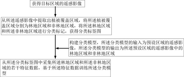
[0074] Please refer to figure 1 , figure 1 For a schematic flowchart of a classification model training method, Embodiment 1 of the present invention provides a model training method, and the method includes:
[0075] Obtain remote sensing images of the target area;
[0076] Extracting a vegetation coverage area from the remote sensing image, dividing the vegetation coverage area into a forest land area and a non-forest land area, and classifying and labeling the forest land area and the non-forest land area to obtain a classification label map;
[0077] constructing a classification model, the input of the classification model is the remote sensing image of the preset area, and the output of the classification model is the forest land area and the non-forest area in the remote sensing image of the preset area;
[0078] Several characteristic data of the woodland area and the non-forest area are collected from the classification label map, and the classification model is tra...
Embodiment 2
[0115] The second embodiment of the present invention provides a forest land change detection method, and the method includes:
[0116] Use the classification model training method described in Embodiment 1 to train to obtain the third classification model and the fourth classification model;
[0117] Obtain the remote sensing image x of the area to be detected in the A period and the remote sensing image y of the to-be-detected area in the B period, wherein the A period is before the B period;
[0118] Inputting the remote sensing image x into the third classification model, and outputting the forestland area K in the remote sensing image x;
[0119] The remote sensing image y is input into the fourth classification model, and the forest area P in the remote sensing image y is output;
[0120] Based on the difference between the forest land area K and the forest land area P, a result map of forest land change detection of the to-be-detected area is obtained.
[0121] Wherei...
Embodiment 3
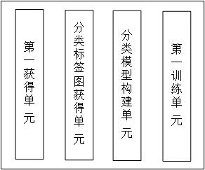
[0125] Please refer to figure 2 , figure 2 A schematic diagram of the composition of the model training system, the third embodiment of the present invention provides a model training system, the system includes:
[0126] a first obtaining unit, used for obtaining remote sensing images of the target area;
[0127] a classification label map obtaining unit, used for extracting a vegetation coverage area from the remote sensing image, dividing the vegetation coverage area into a forest land area and a non-forest land area, and classifying and labeling the forest land area and the non-forest land area, Get the classification label map;
[0128] a classification model construction unit, configured to construct a classification model, the input of the classification model is the input remote sensing image of the preset area, and the output of the classification model is the forest land area and the non-forest land area in the input remote sensing image;
[0129] A first traini...
PUM
 Abstract
Description
Claims
Application Information
 - R&D
- Intellectual Property
- Life Sciences
- Materials
- Tech Scout
- Unparalleled Data Quality
- Higher Quality Content
- 60% Fewer Hallucinations
Browse by: Latest US Patents, China's latest patents, Technical Efficacy Thesaurus, Application Domain, Technology Topic, Popular Technical Reports.
© 2025 PatSnap. All rights reserved.Legal|Privacy policy|Modern Slavery Act Transparency Statement|Sitemap|About US| Contact US: help@patsnap.com