Three-dimensional map reconstruction method based on navigation point selection

A technology of three-dimensional maps and navigation points, which is applied in the re-radiation of electromagnetic waves, the use of re-radiation, measurement devices, etc., can solve the problems of inability to carry out detailed reconstruction in the area, time-consuming, low efficiency, etc., and achieve strong environmental adaptability, The effect of improving accuracy and speeding up

Pending Publication Date: 2021-03-16
ZHEJIANG LAB
View PDF0 Cites 0 Cited by
  • Summary
  • Abstract
  • Description
  • Claims
  • Application Information

AI Technical Summary

Problems solved by technology

Most of the current 3D reconstruction methods require hand-held depth cameras to collect data, and then carry out online or offline 3D reconstruction. Simple regular movement, three-dimensional mapping of the surrounding environment, the disadvantage is that the edges and corners cannot be carefully reconstructed

Method used


Image

  • Three-dimensional map reconstruction method based on navigation point selection
  • Three-dimensional map reconstruction method based on navigation point selection
  • Three-dimensional map reconstruction method based on navigation point selection

Examples


Embodiment Construction

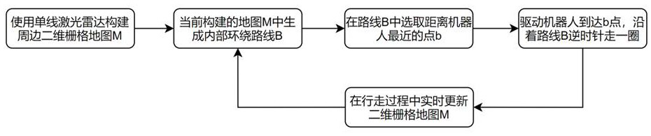
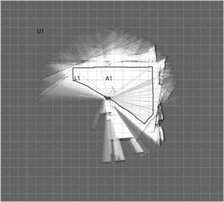
[0017] like figure 1 It is a flowchart of a three-dimensional map reconstruction method based on navigation point selection in the present invention, and the three-dimensional map reconstruction method includes the following steps:

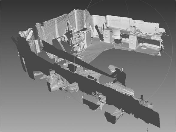
[0018] Step 1: In an indoor environment, place a robot. The chassis of the robot has its own odometer, and the robot can move freely on the ground. At the same time, the odometer of the chassis can output the data information of the wheel speedometer and IMU. A single-line laser radar is installed at a position where the chassis height of the robot is 10-20cm, which can detect obstacles and is conducive to planning the movement trajectory of the robot. At the same time, it is necessary to ensure that the single-line laser radar is blocked by less than 90°; The chassis height of the robot is 40-60cm, and an RGBD camera is installed. This height is the height where most objects in the room are located. Selecting such a height can better reconstruct...


PUM


Abstract

The invention discloses a three-dimensional map reconstruction method based on navigation point selection, and belongs to the technical field of map three-dimensional reconstruction. The three-dimensional map reconstruction method comprises the following steps: scanning an indoor environment by using a single-line laser radar, establishing a two-dimensional grid map, selecting a plurality of navigation points close to the boundary of the map on the obtained two-dimensional grid map, forming a route according to the navigation points, and driving a robot to perform three-dimensional reconstruction while walking along the route, according to the method, scanning can be carried out on an area with more objects at the boundary of the map, the established two-dimensional grid map range is gradually expanded in the walking process, and all three-dimensional maps of the current indoor scene can be established after multiple cycles. The three-dimensional map reconstruction method provided by the invention has the characteristics of complete map construction and capability of better reconstructing the indoor environment edge area objects.

Description

technical field [0001] The present invention belongs to Figure 3 The technical field of dimensional reconstruction, in particular, relates to a three-dimensional map reconstruction method based on navigation point selection. Background technique [0002] 3D reconstruction refers to the establishment of a mathematical model suitable for computer representation and processing of 3D objects. It is the basis for processing, operating and analyzing its properties in a computer environment. [0003] In computer vision, 3D reconstruction refers to the process of reconstructing 3D information from single-view or multi-view images. Since the information of a single video is incomplete, 3D reconstruction requires the use of empirical knowledge. The multi-view three-dimensional reconstruction (similar to human binocular positioning) is relatively easy. The method is to calibrate the camera first, that is, to calculate the relationship between the camera's image coordinate system and ...

Claims


Application Information

Patent Timeline
Patent Type & Authority Applications(China)
IPC IPC(8): G01S17/89G01S17/86
CPCG01S17/89G01S17/86
Inventor 朱世强姜峰顾建军钟心亮李特
Owner ZHEJIANG LAB
Why Eureka
Try Eureka