
Agriculture and forestry area returned farmland information collection method

An acquisition method, agriculture and forestry technology, applied in the field of information acquisition of returned farmland in agriculture and forestry areas, can solve the problems of accuracy uncertainty, inability to effectively extract farmland information, and inconsistency, and achieve the effect of improving accuracy

Pending Publication Date: 2020-11-27
中科海慧(天津)科技有限公司
View PDF6 Cites 3 Cited by
  • Summary
  • Abstract
  • Description
  • Claims
  • Application Information

AI Technical Summary

Problems solved by technology

The problem with this is that the types of crops are different, and the planting time may vary greatly, and the classification method is mostly obtained by using one phase, so there may be some farmland information that cannot be effectively extracted; Second, the characteristic of returned farmland is that the spatial distribution is relatively scattered, and the plots are relatively small, and there may be mixed situations of farmland, forest land, grassland, bare soil, water, etc., so the extraction results have greater uncertainty; It is a method of land use classification, and the calculation amount is relatively large, and the calculation resource consumption is relatively high. In addition, due to the selection of training samples and other reasons, the results of each land use classification will have certain differences.
[0006] Based on the above problems, there is a certain degree of uncertainty in the accuracy of the traditional remote sensing method for extracting fallow land.

Method used


Image

  • Agriculture and forestry area returned farmland information collection method
  • Agriculture and forestry area returned farmland information collection method
  • Agriculture and forestry area returned farmland information collection method

Examples


Embodiment Construction

[0047] In order to make the purpose, technical solutions and advantages of the embodiments of the present invention clearer, the technical solutions in the embodiments of the present invention will be clearly and completely described below in conjunction with the drawings in the embodiments of the present invention. Obviously, the described embodiments It is a part of embodiments of the present invention, but not all embodiments. Based on the embodiments of the present invention, all other embodiments obtained by persons of ordinary skill in the art without creative efforts fall within the protection scope of the present invention.

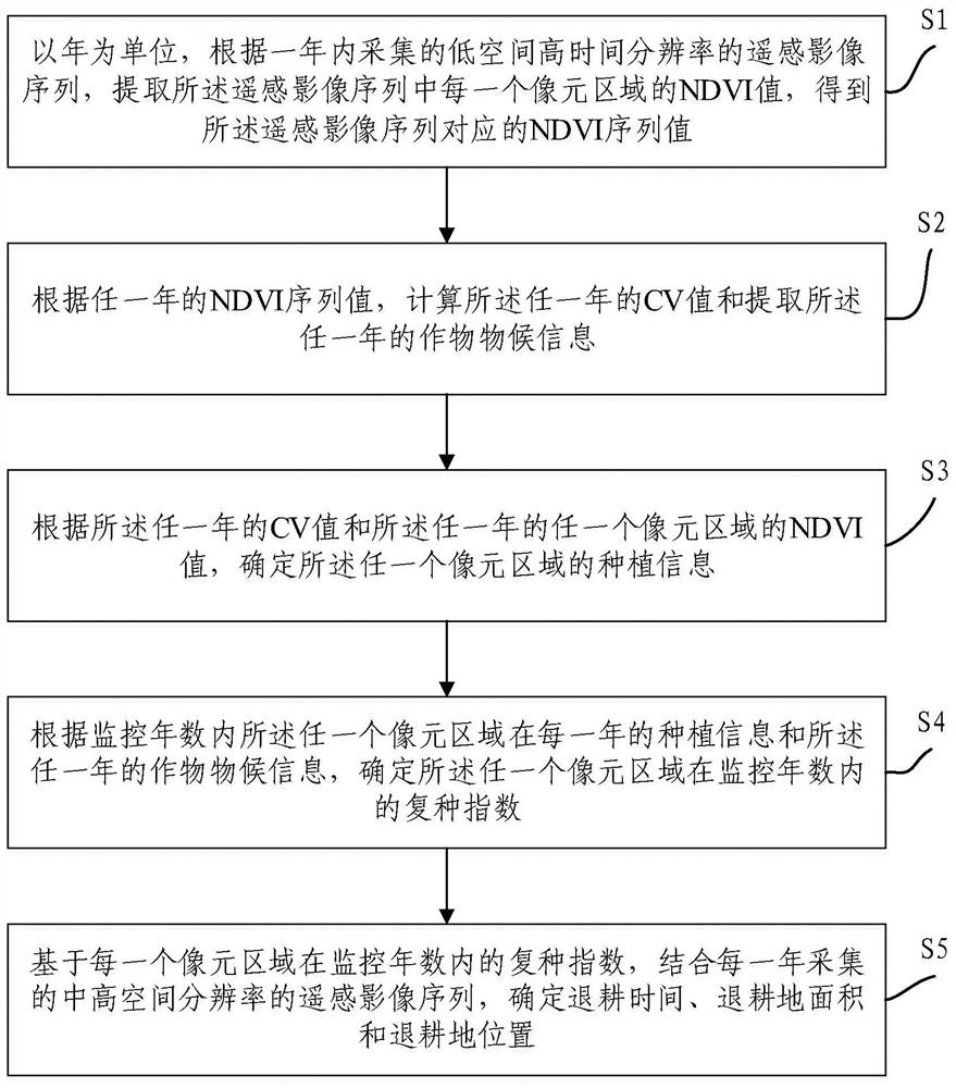
[0048] see figure 1 , providing a method for obtaining information on converted farmland in agricultural and forestry areas, including:

[0049]S1, taking the year as the unit, extract the NDVI value of each pixel area in the remote sensing image sequence according to the remote sensing image sequence with low spatial and high temporal resolution...


PUM


Abstract

The invention provides an agriculture and forestry area returned farmland information collection method, which comprises the steps of collecting an NDVI sequence value within one year according to a remote sensing image with low space and high time resolution; calculating a CV value of any year and extracting crop phenological information according to the NDVI sequence value, and further determining planting information of any pixel area; according to the planting information and the crop phenology information, determining a multiple cropping index of any pixel area within a monitoring year; and based on the multiple cropping index and in combination with a remote sensing image sequence with medium-high spatial resolution, accurately determining the farmland returning time, the farmland returning area and the farmland returning position. According to the method, the NDVI value of the time sequence is collected by utilizing the agricultural and forestry area remote sensing image with low space and high time resolution, the returned farmland position, returned farmland time and returned farmland area are calculated, then the returned farmland information is collected by applying theremote sensing image with medium-high resolution and combining different multiple cropping index remote sensing models, and the information extraction precision is improved.

Description

technical field [0001] The invention relates to the technical field of agriculture and forestry protection, in particular to a method for acquiring information on converted farmland in agriculture and forestry areas. Background technique [0002] For the protection of some ecologically fragile or important ecological function areas, some farmland needs to be returned to forests and grasslands to maximize the value of the ecosystem. [0003] However, from a management point of view, it is necessary to make timely statistics on the specific spatial location and area of ​​farmland conversion at different times, and provide certain economic compensation to localities or farmers according to the time and area of ​​farmland conversion. support. [0004] Due to its multi-time, multi-space and multi-spectral characteristics, remote sensing technology can effectively obtain relevant information on land cover and changes, so it has irreplaceable potential for the identification of fa...

Claims


Application Information

Patent Timeline
IPC IPC(8): G06Q50/02G06K9/00
CPCG06Q50/02G06V20/188
Inventor 杨邦会王树东王春红殷健胡乔利温莹莹刘利
Owner 中科海慧(天津)科技有限公司
Learn More