A Bare Soil Moisture Content Inversion Method Based on Dual Polarization-like Emissivity

A technology of soil water content and emissivity, applied in the field of microwave remote sensing, can solve problems such as inability to obtain valid data, information matching, and influence on microwave brightness temperature, so as to avoid the problem of inversion error of bare soil water content, simplify the inversion process, Effects of Improving Inversion Accuracy

Active Publication Date: 2021-05-25
自然资源部国土卫星遥感应用中心
View PDF0 Cites 0 Cited by
  • Summary
  • Abstract
  • Description
  • Claims
  • Application Information

AI Technical Summary

Problems solved by technology

There are generally two ways to obtain temperature data. One is to establish the empirical relationship between remote sensing brightness temperature and soil temperature by means of thermal infrared remote sensing. The soil temperature calculated by this method is the indicated temperature, which corresponds to the temperature mechanism corresponding to the penetration of microwave remote sensing into the soil layer. It does not match, and is affected by cloud occlusion and weather, sometimes it is impossible to obtain valid data; the second is to obtain it through ground measurement of temperature measuring instruments. information matches
Both methods will lead to the introduction of new errors and reduce the accuracy of soil water content inversion; 2) Since the roughness affects the microwave brightness temperature, the inversion process requires the input of surface roughness information to correct the influence of roughness, but due to Surface roughness is difficult to obtain, so empirical values ​​are generally used in the inversion algorithm. This method cannot be applied to complex surface conditions in reality

Method used


Image

  • A Bare Soil Moisture Content Inversion Method Based on Dual Polarization-like Emissivity
  • A Bare Soil Moisture Content Inversion Method Based on Dual Polarization-like Emissivity
  • A Bare Soil Moisture Content Inversion Method Based on Dual Polarization-like Emissivity

Examples


Embodiment 1

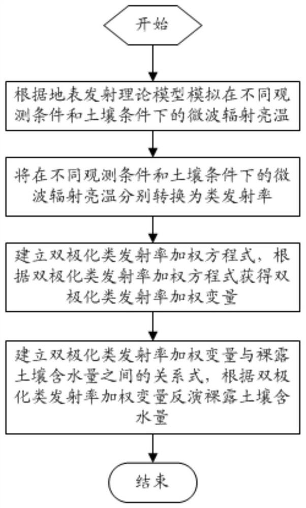
[0035] Embodiment 1, a bare soil water content inversion method based on dual-polarization emissivity, comprising the following steps:

[0036] S1) Establish a theoretical model of surface emission, and simulate the brightness temperature of microwave radiation under different observation conditions and soil conditions according to the theoretical model of surface emission; including the following steps:

[0037] S11) Obtain surface parameters and radiometer observation parameters to be input into the surface emission theory model; surface parameters include surface temperature, bare soil moisture content and surface roughness; radiometer observation parameters include polarization, observation angle and observation frequency;

[0038] S12) Determine the reasonable value range of the surface parameters and the reasonable value range of the radiometer observation parameters, and take values ​​of the surface parameters at equal intervals within the reasonable value range of the s...


PUM

PropertyMeasurementUnit
angle of incidenceaaaaaaaaaa

Abstract

The invention relates to the field of microwave remote sensing, and discloses a method for inversion of bare soil water content based on dual polarized emissivity, comprising the steps of: simulating the microwave radiation brightness temperature under different observation conditions and soil conditions; Convert them into emissivity-like rates respectively to obtain the microwave radiation brightness temperature class emissivity data set; obtain the dual-polarization class emissivity weighted variables according to the dual-polarization class emissivity weighting equation; establish the dual-polarization class emissivity weighting variables and the bare soil content. The relationship between the water content, and the bare soil water content is inverted according to the bipolar emissivity-like weighted variable. The invention defines the emissivity-like rate, avoids the error caused by the temperature data to the inversion process of soil water content, and improves the inversion accuracy. The invention eliminates the influence of the surface roughness on the microwave radiation signal through the weighting of the emissivity-like rate of dual polarization. At the same time, it avoids the inversion error of bare soil water content caused by the use of empirical roughness parameters for different surface conditions in the traditional inversion method.

Description

technical field [0001] The invention relates to the field of microwave remote sensing, in particular to a method for retrieving bare soil water content based on dual-polarization emissivity. Background technique [0002] Soil water content is the most active element in the exchange of energy and water between the land surface and the atmosphere, and is one of the key parameters affecting hydrological, ecological, and biogeochemical processes. With the increasing demand for long-term and large-scale soil water content data in agriculture, water conservancy, disasters and other fields, traditional ground measurement methods can no longer meet the application needs of various fields. Passive microwave remote sensing has the characteristics of being able to work all-weather and all-weather, and has a certain penetrating ability to land surface vegetation and soil, and has gradually become an effective tool for monitoring regional and global soil moisture content. [0003] In ge...

Claims


Application Information

Patent Timeline
Patent Type & Authority Patents(China)
IPC IPC(8): G01N33/24G01N22/04G01N21/17
CPCG01N21/17G01N22/04G01N33/246G01N2021/1793
Inventor 张涛王光辉齐建伟戴海伦郑利娟张伟魏海
Owner 自然资源部国土卫星遥感应用中心
Why Eureka
Try Eureka