Indoor map construction method based on laser radar

A technology of laser radar and indoor map, applied in the field of robots, to achieve the effect of barrier-free travel, strong ranging performance, and accurate data collection capabilities

Pending Publication Date: 2020-11-17
凯思特天宇控股(北京)有限公司
View PDF0 Cites 3 Cited by
  • Summary
  • Abstract
  • Description
  • Claims
  • Application Information

AI Technical Summary

Problems solved by technology

[0006] The embodiment of the present invention provides a lidar-based indoor map construction method to solve the technical problem of the challenge of robot movement in changing environments

Method used


Image

  • Indoor map construction method based on laser radar
  • Indoor map construction method based on laser radar
  • Indoor map construction method based on laser radar

Examples


Embodiment Construction

[0040] In order to enable those skilled in the art to better understand the technical solutions in the present invention, the technical solutions in the embodiments of the present invention will be clearly and completely described below in conjunction with the drawings in the embodiments of the present invention. Obviously, the described The embodiments are only some of the embodiments of the present invention, not all of them. Based on the embodiments of the present invention, all other embodiments obtained by persons of ordinary skill in the art without making creative efforts shall fall within the protection scope of the present invention.

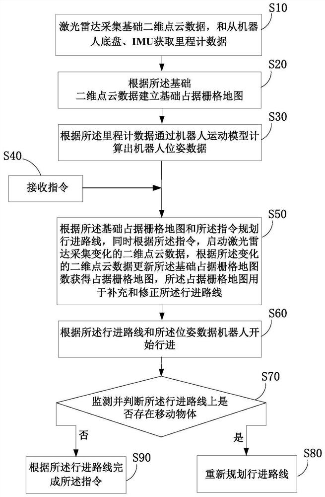
[0041] figure 1 A flow chart of a lidar-based indoor map construction method provided by an embodiment of the present invention, as shown in figure 1 As shown, the map construction method includes the following steps.

[0042] S10: Lidar collects basic two-dimensional point cloud data, and obtains odometer data from the robot chassi...


PUM


Abstract

The invention provides an indoor map construction method based on a laser radar. The method comprises the steps: collecting, by the laser radar, the basic two-dimensional point cloud data and acquiring the odometer data from a robot chassis and an IMU; establishing a basic occupation grid map according to the basic two-dimensional point cloud data; calculating robot pose data through a robot motion model according to the odometer data; receiving an instruction; planning an advancing route according to the basic occupied grid map and the instruction, starting a laser radar to acquire changed two-dimensional point cloud data according to the instruction, and updating the basic occupied grid map data according to the changed two-dimensional point cloud data to obtain an occupied grid map; enabling the robot to move according to the advancing route and the pose data, and meanwhile, monitoring and judging whether a moving object exists on the advancing route or not; and if the moving objectexists, re-planning the advancing route. The map construction method provided by the invention has the characteristics of simply, quickly and accurately identifying the moving object and updating theadvancing route, and can adapt to variable environments.

Description

technical field [0001] The invention relates to the technical field of robots, in particular to a lidar-based indoor map construction method. Background technique [0002] In the fields of navigation, simulation, robotics and many other intelligent control or intelligent devices, it is necessary to use two-dimensional or three-dimensional electronic maps as the basis for further development or use. Therefore, it is fast, effective and accurate to map the real environment It is a technical technology widely used in the field of intelligent control or intelligent equipment to convert the real environment into a two-dimensional or three-dimensional electronic map. In the field of mobile robots, a good electronic map is the premise and foundation for robots to move autonomously. [0003] At present, robots are mainly used in the following fields: industrial robots, special robots, service robots, medical robots, educational robots and other fields. Among them, service robots n...

Claims


Application Information

Patent Timeline
Patent Type & Authority Applications(China)
IPC IPC(8): G01C21/20G01C21/16G01S17/894G01S7/48
CPCG01C21/165G01C21/206G01S7/4808G01S17/894
Inventor 刘倩
Owner 凯思特天宇控股(北京)有限公司
Why Eureka
Try Eureka