Terrain adaptive interpolation filtering method suitable for airborne LiDAR point cloud

An interpolation filtering and adaptive technology, applied in the field of terrain adaptive interpolation filtering, can solve the problems of reducing filtering accuracy, missing or misclassifying point clouds, time-consuming and laborious, etc., to improve accuracy, avoid the influence of spatial position errors, and reduce manual labor. The effect of interactive workload

Active Publication Date: 2020-08-28
SHANDONG UNIV OF SCI & TECH
View PDF3 Cites 1 Cited by
  • Summary
  • Abstract
  • Description
  • Claims
  • Application Information

AI Technical Summary

Problems solved by technology

[0014] A large number of experimental analysis shows that the existing filtering methods can achieve better filtering accuracy in simple areas of the scene, but in complex areas of the scene, it is easy to cause the problem of point cloud omission or misclassification, which reduces the filtering accuracy and requires a lot of manual editing in the future. The work is time-consuming and labor-intensive, and the accuracy of point cloud editing depends entirely on the proficiency of the operator, which is highly subjective

Method used


Image

  • Terrain adaptive interpolation filtering method suitable for airborne LiDAR point cloud
  • Terrain adaptive interpolation filtering method suitable for airborne LiDAR point cloud
  • Terrain adaptive interpolation filtering method suitable for airborne LiDAR point cloud

Examples


Embodiment Construction

[0079] Below in conjunction with accompanying drawing and specific embodiment the present invention is described in further detail:

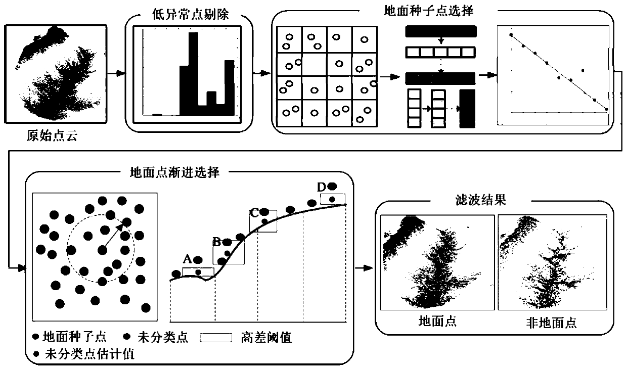
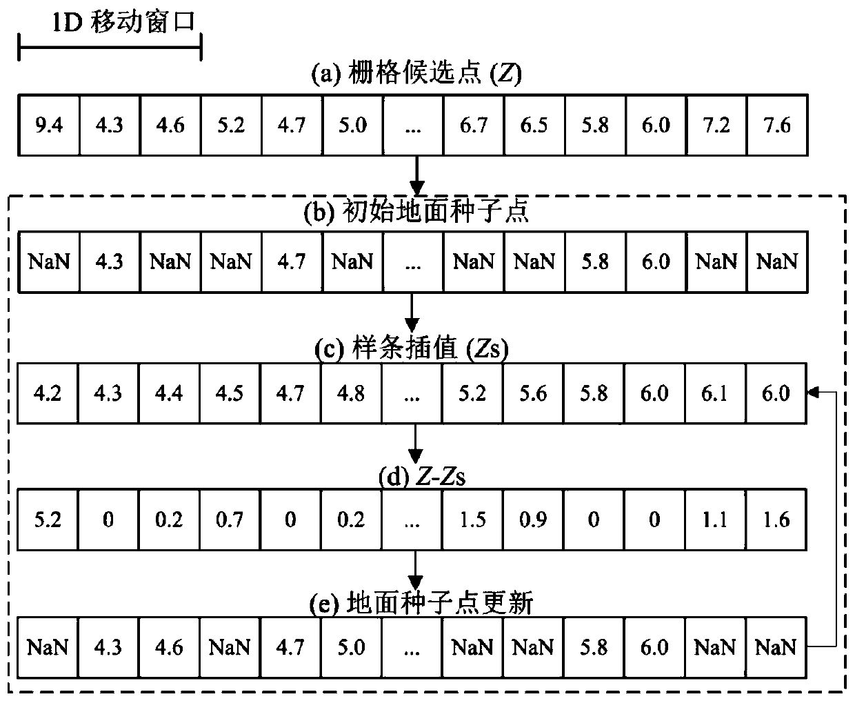
[0080] Such as figure 1 As shown, a terrain adaptive interpolation filtering method suitable for airborne LiDAR point cloud includes the following steps:

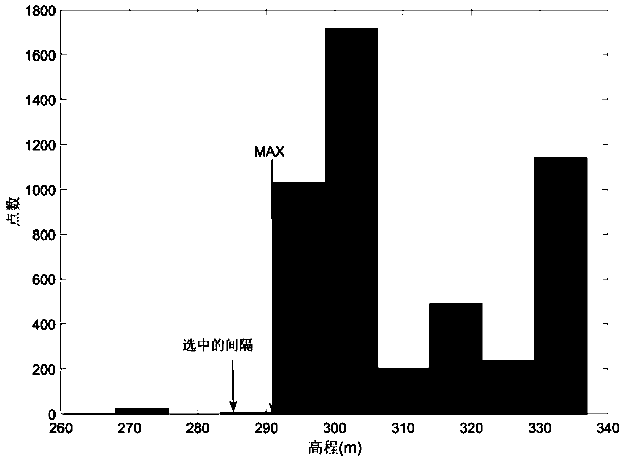
[0081] I. Utilize the elevation histogram to automatically remove low outliers in the raw point cloud.

[0082] The low outliers in the original point cloud are removed to avoid misselection as the initial ground seed point. Due to the influence of LiDAR system error and multipath, the original point cloud inevitably contains outliers. There are two types of outliers: low outliers and high outliers.

[0083] The former is significantly lower than other point clouds, while the latter is significantly higher than other point clouds.

[0084] In the calculation process of the traditional interpolation filtering method, the lowest point of the local neighborhood needs to be selected as the ini...


PUM


Abstract

The invention discloses a terrain adaptive interpolation filtering method suitable for airborne LiDAR point cloud. The terrain adaptive interpolation filtering method comprises the steps of removing low abnormal points, selecting ground seed points, checking the ground seed points, progressively selecting the ground points and the like, wherein in the step of removing the low abnormal points, automatic removal of the low abnormal points is realized by adopting an elevation histogram, so that the manual intervention degree is reduced; in the step of selecting the ground seed points, a large number of ground seed points are obtained by utilizing a one-dimensional discrete smooth spline, so that the precision of an initial ground reference surface is improved; in the step of ground point progressive selection, a to-be-classified point value is estimated by adopting scale-independent interpolation so as to avoid the influence of a spatial position error; and in addition, a terrain adaptivefiltering threshold value is also adopted to adapt to point clouds of different terrain scenes so as to reduce the levels of wrong classification and missing classification of the point clouds of scenic spots of different terrain scenes. The terrain adaptive interpolation filtering method is beneficial to improving the precision of point cloud filtering.

Description

technical field [0001] The invention relates to a terrain adaptive interpolation filtering method suitable for airborne LiDAR point clouds. Background technique [0002] At present, airborne laser radar (LiDAR) technology has become the main means of 3D spatial data acquisition due to its initiative and high efficiency, and is widely used in the fields of digital elevation model production, 3D city construction, forest resource survey, and landslide monitoring. . Different from the direct contact data collection method, the original airborne LiDAR point cloud data includes various ground points and non-ground points. Therefore, the original airborne LiDAR point cloud data must be filtered before use. [0003] In the past two decades, many researchers at home and abroad have proposed various point cloud filtering algorithms. According to the working principle, the existing filtering algorithms can be divided into slope filtering, morphological filtering, interpolation filte...

Claims


Application Information

Patent Timeline
Patent Type & Authority Applications(China)
IPC IPC(8): G06T3/40G06T5/00G06T7/187G06T7/194G06T17/20
CPCG06T3/4023G06T5/002G06T7/187G06T7/194G06T17/205G06T2207/10044G06T2207/10028
Inventor 陈传法李艳艳郭斌闫长青常兵涛
Owner SHANDONG UNIV OF SCI & TECH
Why Eureka
Try Eureka