A slope adjustment method, device and equipment based on GNSS single-antenna satellite
A single-antenna, satellite technology, applied in the field of land survey and improvement, can solve the problems of multiple antenna satellites, too much data, etc.
- Summary
- Abstract
- Description
- Claims
- Application Information
AI Technical Summary
Problems solved by technology
Method used
Image
Examples
specific Embodiment approach
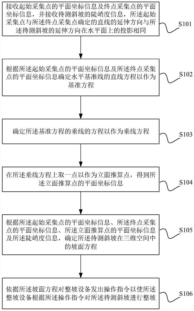
[0047] The core of the present invention is to provide a kind of whole slope method based on GNSS single-antenna satellite, and the schematic flow chart of its a kind of specific implementation is as figure 1 As shown, it is called the first specific implementation mode, including:
[0048] Step S101: receiving the plane coordinate information of the start collection point and the plane coordinate information of the end point collection point, and receiving the steepness information of the slope to be measured, the extension direction of the straight line determined by the start collection point and the end point collection point is consistent with The projections of the extending direction of the slope to be measured on the horizontal plane are the same.
PUM
 Abstract
Description
Claims
Application Information
 - R&D
- Intellectual Property
- Life Sciences
- Materials
- Tech Scout
- Unparalleled Data Quality
- Higher Quality Content
- 60% Fewer Hallucinations
Browse by: Latest US Patents, China's latest patents, Technical Efficacy Thesaurus, Application Domain, Technology Topic, Popular Technical Reports.
© 2025 PatSnap. All rights reserved.Legal|Privacy policy|Modern Slavery Act Transparency Statement|Sitemap|About US| Contact US: help@patsnap.com


