
Altitude measurement method and electronic equipment

A technology of altitude and electronic equipment, which is applied in the field of altitude measurement and electronic equipment, can solve problems such as low positioning accuracy, wrong road selection, and inaccurate positioning, so as to ensure universality and practicability, and solve the problem of altitude The effect of lower measurement accuracy

Inactive Publication Date: 2020-08-04
HUAWEI TECH CO LTD
View PDF0 Cites 2 Cited by
  • Summary
  • Abstract
  • Description
  • Claims
  • Application Information

AI Technical Summary

Problems solved by technology

GPS and other satellite positioning technologies have higher coordinate positioning accuracy in the plane direction, but lower positioning accuracy in the altitude direction
Therefore, in the face of complex three-dimensional traffic, even if travelers use the navigation and positioning function of electronic devices to choose travel routes, they may still choose the wrong road due to the inaccurate positioning in the direction of altitude.

Method used


Image

  • Altitude measurement method and electronic equipment
  • Altitude measurement method and electronic equipment
  • Altitude measurement method and electronic equipment

Examples


Embodiment Construction

[0068] Hereinafter, the implementation manner of this embodiment will be described in detail with reference to the accompanying drawings. Among them, in the description of the embodiments of this application, unless otherwise specified, " / " means or means, for example, A / B can mean A or B; "and / or" in this article is only a description of associated objects The association relationship of indicates that there may be three kinds of relationships, for example, A and / or B may indicate: A exists alone, A and B exist simultaneously, and B exists independently. In addition, in the description of the embodiments of the present application, "plurality" refers to two or more than two.

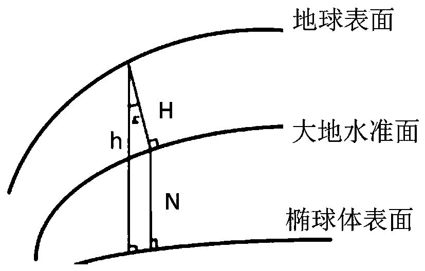
[0069] Figure 1A It is a schematic diagram of a possible application scenario applicable to this embodiment of the application. Such as Figure 1A As shown, the user may face three-dimensional traffic when traveling. The three-dimensional traffic in this embodiment includes, but is not limited to: tr...


PUM


Abstract

The embodiment of the invention provides an altitude measurement method and electronic equipment, and relates to the technical field of positioning and navigation. The method comprises the following steps: 1, when the electronic equipment is located at the first position, the altitude corresponding to the first position is obtained through a navigation positioning device and an electronic map, andwhen the electronic equipment moves from the first position to the second position, the altitude corresponding to the second position is obtained according to the altitude corresponding to the firstposition and the sensor data measured by the sensor. According to the scheme, the altitude measurement precision can be improved. In addition, the hardware cost of the electronic equipment does not need to be increased, and the universality and the practicability of the scheme are guaranteed.

Description

technical field [0001] The present application relates to the field of terminal technologies, and in particular to a method for measuring altitude and electronic equipment. Background technique [0002] With the three-dimensional development of urban traffic, traffic forms such as viaducts, overpasses, and tunnels are becoming more and more common. These three-dimensional traffic is of great significance to the development of urban traffic and the rapid passage of vehicles. However, the three-dimensional traffic brings difficulties to the traveler's road choice to a certain extent. Travelers often choose the wrong road when facing the intricate three-dimensional traffic. [0003] At present, users can use electronic devices with navigation and positioning functions to select travel routes. Currently, the navigation and positioning functions of electronic devices mainly rely on satellite positioning technologies such as the global positioning system (GPS). GPS and other s...

Claims


Application Information

Patent Timeline
Patent Type & Authority Applications(China)
IPC IPC(8): G01C5/06
CPCG01C5/06
Inventor 范振华张欣悦
Owner HUAWEI TECH CO LTD
Learn More