Path optimization method for multi-UAV cooperative inspection tasks

A technology for inspection missions and multi-UAVs, applied in vehicle position/route/height control, instruments, three-dimensional position/channel control, etc., can solve the problems of unoptimized UAV path and low quality of inspection tasks , to achieve the effect of improving the quality of completion, optimizing the number of visits, and good robustness

Active Publication Date: 2021-09-28
HEFEI UNIV OF TECH
View PDF6 Cites 0 Cited by
  • Summary
  • Abstract
  • Description
  • Claims
  • Application Information

AI Technical Summary

Problems solved by technology

Therefore, the path of the UAV cannot be optimized, and the quality of the inspection task is low.

Method used


Image

  • Path optimization method for multi-UAV cooperative inspection tasks
  • Path optimization method for multi-UAV cooperative inspection tasks
  • Path optimization method for multi-UAV cooperative inspection tasks

Examples


Embodiment Construction

[0064] In order to make the purpose, technical solutions and advantages of the embodiments of the present invention clearer, the technical solutions in the embodiments of the present invention are clearly and completely described. Obviously, the described embodiments are part of the embodiments of the present invention, not all of them. example. Based on the embodiments of the present invention, all other embodiments obtained by persons of ordinary skill in the art without making creative efforts belong to the protection scope of the present invention.

[0065] The embodiment of the present application provides a heterogeneous multi-UAV collaborative task assignment and path optimization method.

[0066] The technical solution in the embodiment of the present application is to solve the above-mentioned technical problems, and the general idea is as follows:

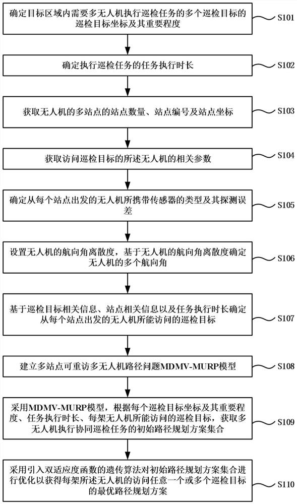
[0067] First determine the relevant parameters of multiple inspection targets that require multiple UAVs to perform in...


PUM


Abstract

The present invention provides a path optimization method for multi-UAV collaborative inspection tasks, and specifically relates to the technical field of UAVs. Human-machine parameters, site parameters of the drone, and the total task execution time, and set the dispersion of the heading angle of the drone, and then determine the starting point from each site based on the inspection target-related information, site-related information, and task execution time. The inspection targets that UAVs can visit, and at the same time establish and use the multi-site revisitable multi-UAV path problem MDMV‑MURP model to optimize and obtain the optimal path planning scheme for each UAV's visit inspection targets . Based on the method provided by the embodiment of the present invention, the reliability of information acquired by all unmanned aerial vehicles within a given task time can be maximized.

Description

technical field [0001] The invention relates to the technical field of unmanned aerial vehicles, in particular to a path optimization method for multi-unmanned aerial vehicle cooperative inspection tasks. Background technique [0002] UAVs have been widely used in scenarios such as military inspections and power tower inspections. In order to improve the efficiency of inspection tasks, multiple UAVs are usually used to inspect the target area at the same time from different directions, and these UAVs usually start from different stations. UAVs can obtain images of inspection targets through their mounted sensors, and synthesizing images obtained by different types of sensors can greatly improve the credibility of the information obtained, such as: military targets through visible light radar and synthetic aperture radar Or power poles and towers to take pictures. [0003] At present, when the traditional scheme assigns tasks to multiple UAVs performing tasks, it does not c...

Claims


Application Information

Patent Timeline
Patent Type & Authority Patents(China)
IPC IPC(8): G01C21/20G05D1/10
CPCG01C21/20G05D1/104
Inventor 罗贺朱默宁杨善林王国强胡笑旋靳鹏夏维马华伟唐奕城
Owner HEFEI UNIV OF TECH
Why Eureka
Try Eureka