Land planning measurer based on laser surveying and mapping

The technology of a measuring device and a laser range finder, which is applied in the direction of measuring instrument components, measuring devices, and line-of-sight measurement, can solve the problems of unfavorable work of surveyors, increase the workload of surveyors, waste of manpower and material resources, etc., and achieve enhanced Strength, reduce workload, improve the effect of using functions

Inactive Publication Date: 2020-03-13
江苏盐西房地产开发有限公司
View PDF3 Cites 0 Cited by
  • Summary
  • Abstract
  • Description
  • Claims
  • Application Information

AI Technical Summary

Problems solved by technology

[0005] The object of the present invention is to provide a land planning measuring device based on laser surveying and mapping, to solve the problem that most of the existing land planning measuring devices in the above-mentioned background technology are measured by measuring personnel using a tape measure, which increases the workload of the measuring personnel. , and wasted a lot of manpower and material resources, and at the same time reduced work efficiency, which is not conducive to the work of surveyors

Method used


Image

  • Land planning measurer based on laser surveying and mapping
  • Land planning measurer based on laser surveying and mapping
  • Land planning measurer based on laser surveying and mapping

Examples


Embodiment Construction

[0029] The following will clearly and completely describe the technical solutions in the embodiments of the present invention with reference to the drawings in the embodiments of the present invention.

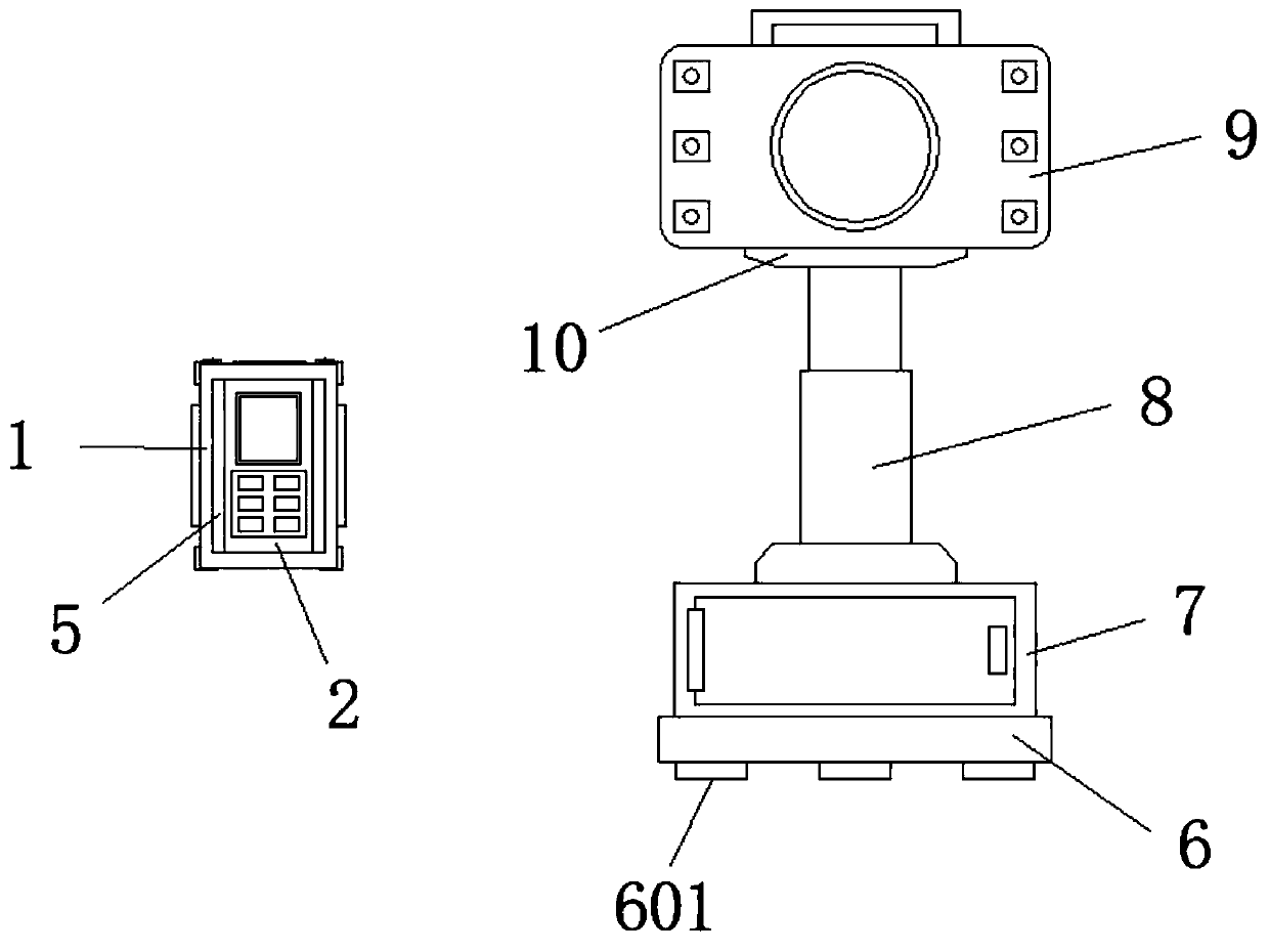
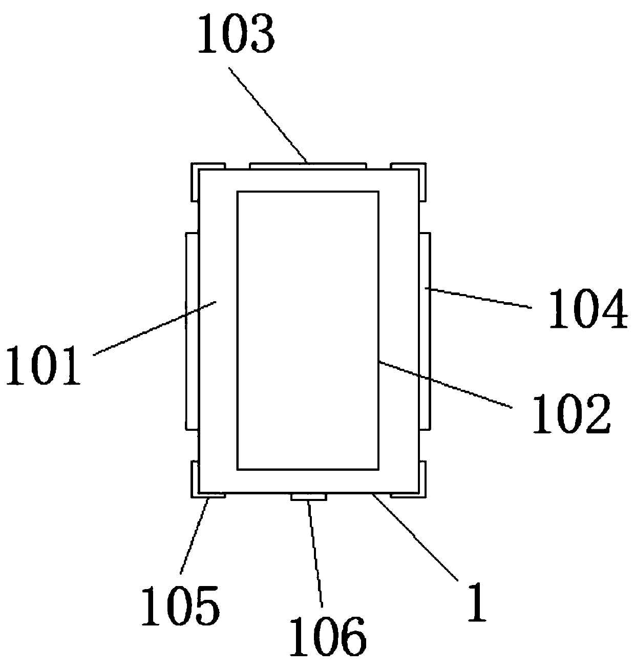
[0030] Such as Figure 1-7 As shown, the present invention provides a technical solution: a land planning measuring device based on laser surveying and mapping, including a protective mechanism 1, a laser range finder 2, a base 6, a storage mechanism 7, a telescopic rod 8, a positioning mechanism 9 and a connecting plate 10. The laser range finder 2 is set on the surface of the protective mechanism 1, the storage mechanism 7 is set on the top surface of the base 6, the telescopic rod 8 is set on the top surface of the storage mechanism 7, and the top end of the telescopic rod 8 is welded with a connection plate 10, and a positioning mechanism 9 is installed on the top surface of the connection plate 10.

[0031]The protective mechanism 1 is composed of a protective shell 101,...


PUM


Abstract

The invention discloses a land planning measurer based on laser surveying and mapping, which comprises a protection mechanism, a laser rangefinder, a base, a storage mechanism, a telescopic rod, a positioning mechanism and a connecting plate. The laser rangefinder is arranged on the surface of the protection mechanism. The storage mechanism is arranged on the surface of the top of the base. The telescopic rod is arranged on the surface of the top of the storage mechanism. The connecting plate is welded at the top end of the telescopic rod. The positioning mechanism is mounted on the surface ofthe top of the connecting plate. Measurement personnel can conveniently measure the distance through matching between the laser rangefinder and a prism plate on the positioning mechanism. The protection mechanism can protect the laser rangefinder. The storage mechanism can store the equipment. LED flashing lamps enable the measurement personnel to conveniently measure and align the prism plate under a dark condition, and therefore, the measurement efficiency is improved.

Description

technical field [0001] The invention relates to the technical field of surveying equipment, in particular to a land planning surveying instrument based on laser surveying and mapping. Background technique [0002] Land planning refers to the long-term arrangements for the rational use of land in a country or a certain region according to the prospects and needs of economic development. The aim is to ensure that the use of land can meet the requirements of the proportional development of various sectors of the national economy. The planning is based on the distribution and allocation of existing natural resources, technical resources and human resources, so as to ensure that the land is fully and effectively used without causing waste due to human factors. The overall planning of land use is the overall arrangement and layout of land development, utilization, management and protection in space and time in a certain area according to the requirements of national social and ec...

Claims


Application Information

Patent Timeline
Patent Type & Authority Applications(China)
IPC IPC(8): G01C3/00G01C3/02G01D11/28
CPCG01C3/00G01C3/02G01D11/28
Inventor 徐玲玲曹青青张勇
Owner 江苏盐西房地产开发有限公司
Why Eureka
Try Eureka