A high-precision dem air gravity far-field terrain correction method considering the curvature of the earth

A technology for aviation gravity and terrain correction, applied in the field of geophysical exploration, can solve the problems of slow calculation speed, not considering the curvature of the earth, difficult to meet production needs, etc., to achieve the effect of improving the accuracy of terrain correction

Active Publication Date: 2021-04-09
XIAN CENT OF GEOLOGICAL SURVEY CGS
View PDF6 Cites 0 Cited by
  • Summary
  • Abstract
  • Description
  • Claims
  • Application Information

AI Technical Summary

Problems solved by technology

However, RGIS software has two defects: one is that high-precision DEM data cannot be used, which is difficult to meet the current high-precision gravity measurement requirements; the other is that the measurement points are required to be located on the ground, which cannot meet the requirements of aviation gravity measurement
At present, foreign airborne gravity surveys are mainly carried out in plain areas.

Method used


Image

  • A high-precision dem air gravity far-field terrain correction method considering the curvature of the earth
  • A high-precision dem air gravity far-field terrain correction method considering the curvature of the earth
  • A high-precision dem air gravity far-field terrain correction method considering the curvature of the earth

Examples


Embodiment Construction

[0041] In order to better explain the present invention and facilitate understanding, the present invention will be described in detail below through specific embodiments in conjunction with the accompanying drawings.

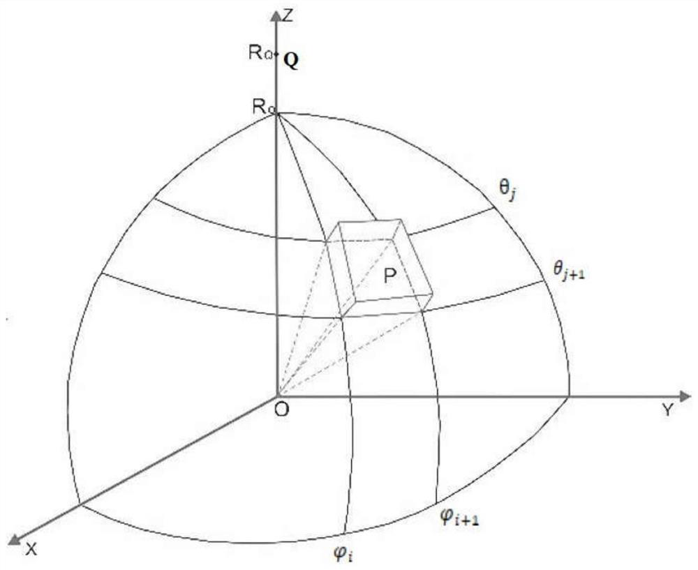
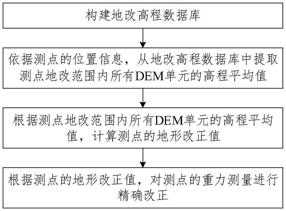
[0042] like figure 1 As shown, the earth is approximated as a sphere, and the center of the earth is the center of the sphere. like figure 2 As shown, in order to consider the curvature of the earth and based on high-precision DEM data, calculate the terrain correction value of air gravity far zone, the applicant calculates by coordinate transformation and ellipsoid integral Point Fan-shaped Cylinder to Aeronautical Gravity Measuring Point The gravity influence value.

[0043] Let the center of the sphere be the origin of the coordinates, the Z axis passes through the top of the sphere (North Pole), and the air gravity measuring point Q is on the Z axis. From the geoid to the free surface of the earth, the area of ​​20 ~ 166.7km around the air gravity me...


PUM


Abstract

A high-precision DEM aviation gravity far-field terrain correction method considering the curvature of the earth, including: S1, obtaining the position information of the measuring point Q. S2. According to the location information of the measuring point Q, extract the elevation average value S3, According to the elevation average value of all DEM units within the range of measuring point Q and the preset calculation formula of measuring point Q terrain correction value, the terrain correction value of measuring point Q is obtained. S4. According to the terrain correction value of the measuring point Q, the gravity measurement of the measuring point Q is accurately corrected. Greatly improve the accuracy of gravity far-field terrain correction, and at the same time, the calculation amount is small and the calculation speed is fast; long-term work can splice the elevation database completed in different periods to update and maintain the elevation database.

Description

technical field [0001] The invention relates to the technical field of geophysical exploration, in particular to a high-precision DEM aerial gravity far-area terrain correction method considering the curvature of the earth. Background technique [0002] The terrain correction in the gravity survey refers to the correction of the quality between the geoid and the natural terrain, which is divided into the near-middle area and the far area. The terrain improvement in the near-middle area is to approximate the earth as an infinite flat plate near the measuring point (within a radius of 2km), to eliminate the influence of material surplus or deficit above or below the plane of the measuring point, and use the plane upright cubic cylinder formula to calculate; the far area Terrain improvement is carried out by the regional gravity database in areas that are far away from the survey point (within 166.7km outside the radius of 2km). Before the gravity database is completed, each un...

Claims


Application Information

Patent Timeline
IPC IPC(8): G01C5/00G01V9/00G06F16/29
CPCG01C5/00G01V9/00G06F16/29
Inventor 冯治汉郭培虹熊盛青
Owner XIAN CENT OF GEOLOGICAL SURVEY CGS
Why Eureka
Try Eureka