
A method for multi-vehicle cooperative rapid map building

A fast, map-based technology, applied in the direction of instruments, measuring devices, electromagnetic wave re-radiation, etc., can solve the problems of reduced mapping efficiency and achieve the effects of improving stability and real-time performance, improving accuracy, and large detection field of view

Active Publication Date: 2022-05-24
BEI JING NORMAL UNIV HONG KONG BAPTIST UNIV UNITED INT COLLEGE
View PDF9 Cites 0 Cited by
  • Summary
  • Abstract
  • Description
  • Claims
  • Application Information

AI Technical Summary

Problems solved by technology

However, when it is extended to 3D, the efficiency of map construction is reduced.

Method used


Image

  • A method for multi-vehicle cooperative rapid map building
  • A method for multi-vehicle cooperative rapid map building
  • A method for multi-vehicle cooperative rapid map building

Examples


Embodiment Construction

[0043] The accompanying drawings are for illustrative purposes only, and should not be construed as limitations on this patent; in order to better illustrate the present embodiment, some parts of the accompanying drawings may be omitted, enlarged or reduced, and do not represent the size of the actual product; for those skilled in the art It is understandable to the artisan that certain well-known structures and descriptions thereof may be omitted from the drawings. The positional relationships described in the drawings are only for exemplary illustration, and should not be construed as a limitation on the present patent.

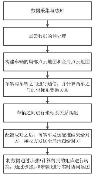
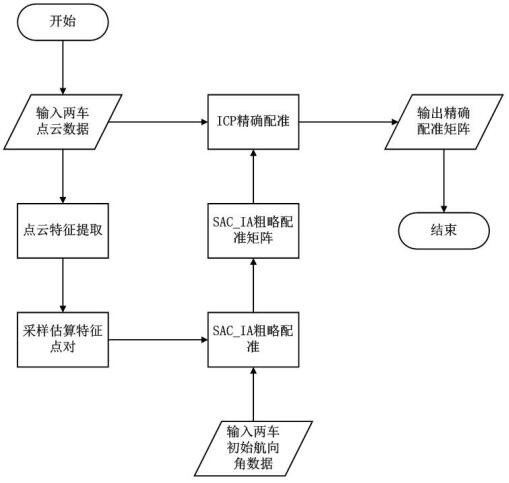
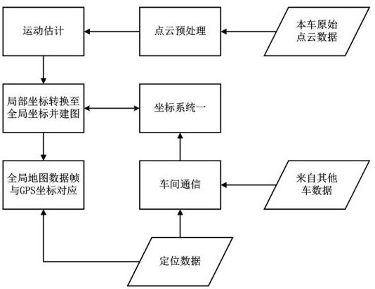
[0044] like Figure 1 to Figure 5 As shown, a multi-vehicle collaborative rapid mapping method includes the following steps:

[0045] Step 1. Collect data at a frequency of 10Hz through a 16-line lidar and record it in the memory in the form of a lidar point cloud; through a GPS device, perceive real-time GPS data at a frequency of 50Hz and store it in the...


PUM


Abstract

The invention relates to a multi-vehicle cooperative rapid map building method. Including the following steps: S1. Data acquisition and perception; S2. Preprocessing of point cloud data; S3. Construction of local point cloud map and global point cloud map of the vehicle; S4. Communication between vehicles and calculation of the distance between the two vehicles The coordinate system transformation relationship between the two vehicles; S5. Match the coordinate system transformation relationship between the vehicles one by one, and if the matching result meets the threshold requirements, it will be used as the coordinate system transformation matrix of the two vehicles; S6. After the registration is successful, each vehicle Send the registration result to the other party. After each vehicle receives the registration result, it starts to send its established global edge map and trajectory to the other party. S7. Each vehicle receives the global edge map and the other party’s trajectory that are continuously sent by the other party. After the data, transform the data through the matrix calculated in step 5, and then transmit the result to step 2 and step 3 for real-time collaborative mapping. The invention uses multi-vehicle cooperative map building, which has high efficiency, large detection field of view, and high precision.

Description

technical field [0001] The invention belongs to the technical field of automatic driving perception, and in particular, relates to a multi-vehicle cooperative rapid mapping method. Background technique [0002] At present, ROS (Robot Operating System) is an open source robot operating system. As a middleware, the system provides the services that the operating system should have: hardware abstraction, low-level device control, implementation of common functions, inter-process message passing, etc. [0003] The main goal of ROS is to provide code reuse support for robotics research and development. ROS adopts a distributed process framework and uses nodes as the basic unit to realize communication. ROS supports a federated system similar to code repositories that also enables project collaboration and distribution. This design enables the development and implementation of a project to be completely independent from the file system to the user interface (not restricted by RO...

Claims


Application Information

Patent Timeline
Patent Type & Authority Patents(China)
IPC IPC(8): G01C21/32
CPCG01S17/06G01S17/88G01S19/46
Inventor 轩辕哲李博洋张心翼
Owner BEI JING NORMAL UNIV HONG KONG BAPTIST UNIV UNITED INT COLLEGE
Learn More