A data update method, device and system

A data update and data packet technology, applied in the Internet field, can solve the problem of slow update speed of geospatial data, and achieve the effect of ensuring accuracy and current situation, and reducing costs.

Active Publication Date: 2021-05-07
苏州朗润创新知识产权运营有限公司
View PDF27 Cites 0 Cited by
  • Summary
  • Abstract
  • Description
  • Claims
  • Application Information

AI Technical Summary

Problems solved by technology

[0004] In view of this, the embodiment of the present application provides a data update method, device and system to solve the technical problem of slow geospatial data update speed in the prior art

Method used


Image

  • A data update method, device and system
  • A data update method, device and system
  • A data update method, device and system

Examples


Embodiment Construction

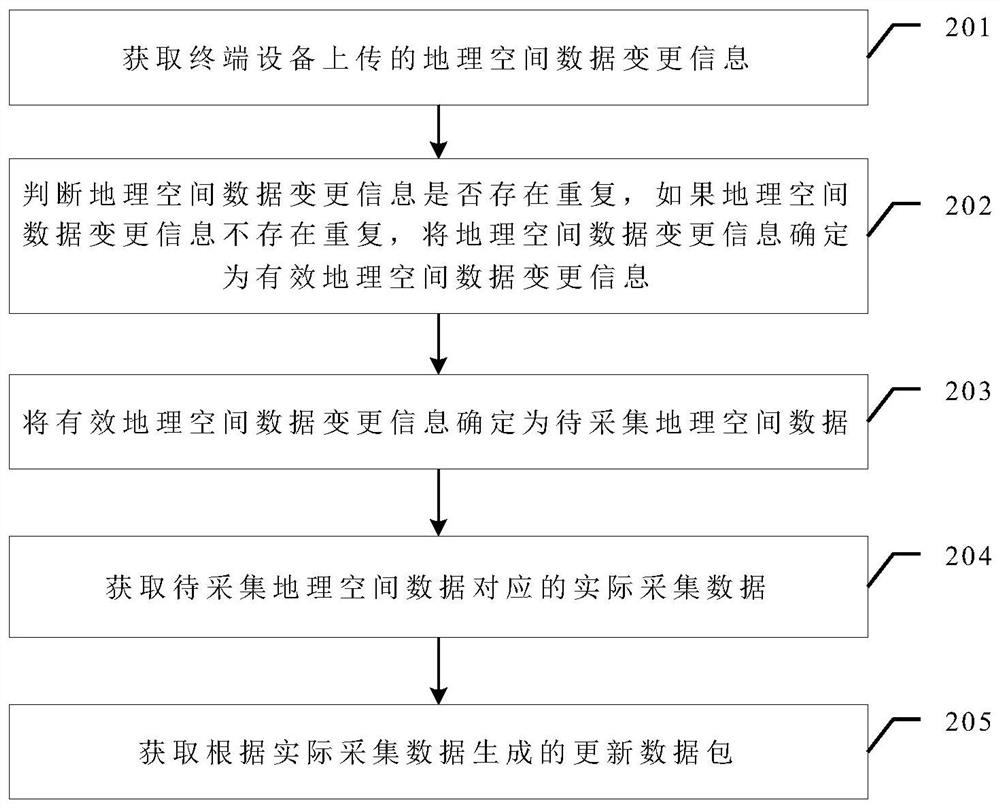
[0058]In order to enable those skilled in the art to better understand the technical solutions in the present invention, the technical solutions in the embodiments of the present invention will be clearly and completely described below in conjunction with the drawings in the embodiments of the present invention. Obviously, the described The embodiments are only some of the embodiments of the present invention, not all of them. Based on the embodiments of the present invention, all other embodiments obtained by persons of ordinary skill in the art without creative efforts shall fall within the protection scope of the present invention.

[0059] In the existing technology, the traditional way of producing and updating geospatial data has a long cycle and consumes a lot of manpower and material resources, which is not suitable for the current fast-growing navigation system industry's requirements for the fineness, accuracy, and current status of geospatial data. . At present, ge...


PUM


Abstract

The application discloses a data updating method, device and system. In this method, after the user discovers that the geospatial data has changed, he can upload the discovered geospatial data change information through the terminal device at any time. After the geospatial data sharing update cloud platform obtains the geospatial data change information uploaded by the terminal device, it first judges the Whether the geospatial data change information is repeated, if not repeated, it is determined as valid geospatial data change information; after that, the effective geospatial data change information is determined as the geospatial data to be collected, and the actual collected data corresponding to the geospatial data to be collected is obtained Then a corresponding update data package can be generated. Since each user can be a discoverer of geospatial data change information, the cost of obtaining geospatial data change information is greatly reduced, so that geospatial data can be updated in a short cycle, ensuring the accuracy and accuracy of geospatial data. current situation.

Description

technical field [0001] The present application relates to the field of Internet technologies, and in particular to a data updating method, device and system. Background technique [0002] In recent years, due to the popularity of car navigation applications and the rapid development of the navigation system industry, higher requirements have been put forward for the fineness, accuracy, and current status of geospatial data. The production and update of traditional geospatial data is generally done by external operators in the actual environment by plotting the location of points of interest on the drawings, recording the attribute information of points of interest, and then returning to the room to process and sort out the geospatial data with reference to the drawings, and finally enter it into the interest In the point database, the operation mode has a long production cycle, wastes manpower and material resources, and is prone to errors. The traditional mode has been diff...

Claims


Application Information

Patent Timeline
Patent Type & Authority Patents(China)
IPC IPC(8): G06F16/23G06F16/29
Inventor 赵立超张艳菊邢超
Owner 苏州朗润创新知识产权运营有限公司
Why Eureka
Try Eureka