
Complex area tour robot positioning, navigation and time service method under non GPS condition

A robot positioning and robot technology, used in navigation and timing, complex area patrol robot positioning, PNT field, can solve the problem of unable to accurately position and navigate, unable to obtain robot attitude and position information, etc.

Inactive Publication Date: 2018-09-28
HENAN INST OF SCI & TECH
View PDF9 Cites 10 Cited by
  • Summary
  • Abstract
  • Description
  • Claims
  • Application Information

AI Technical Summary

Problems solved by technology

However, in an environment with weak or no GPS signal, the attitude and position information of the robot cannot be obtained, and ultimately it cannot be accurately positioned and navigated.

Method used


Image

  • Complex area tour robot positioning, navigation and time service method under non GPS condition
  • Complex area tour robot positioning, navigation and time service method under non GPS condition
  • Complex area tour robot positioning, navigation and time service method under non GPS condition

Examples


Embodiment Construction

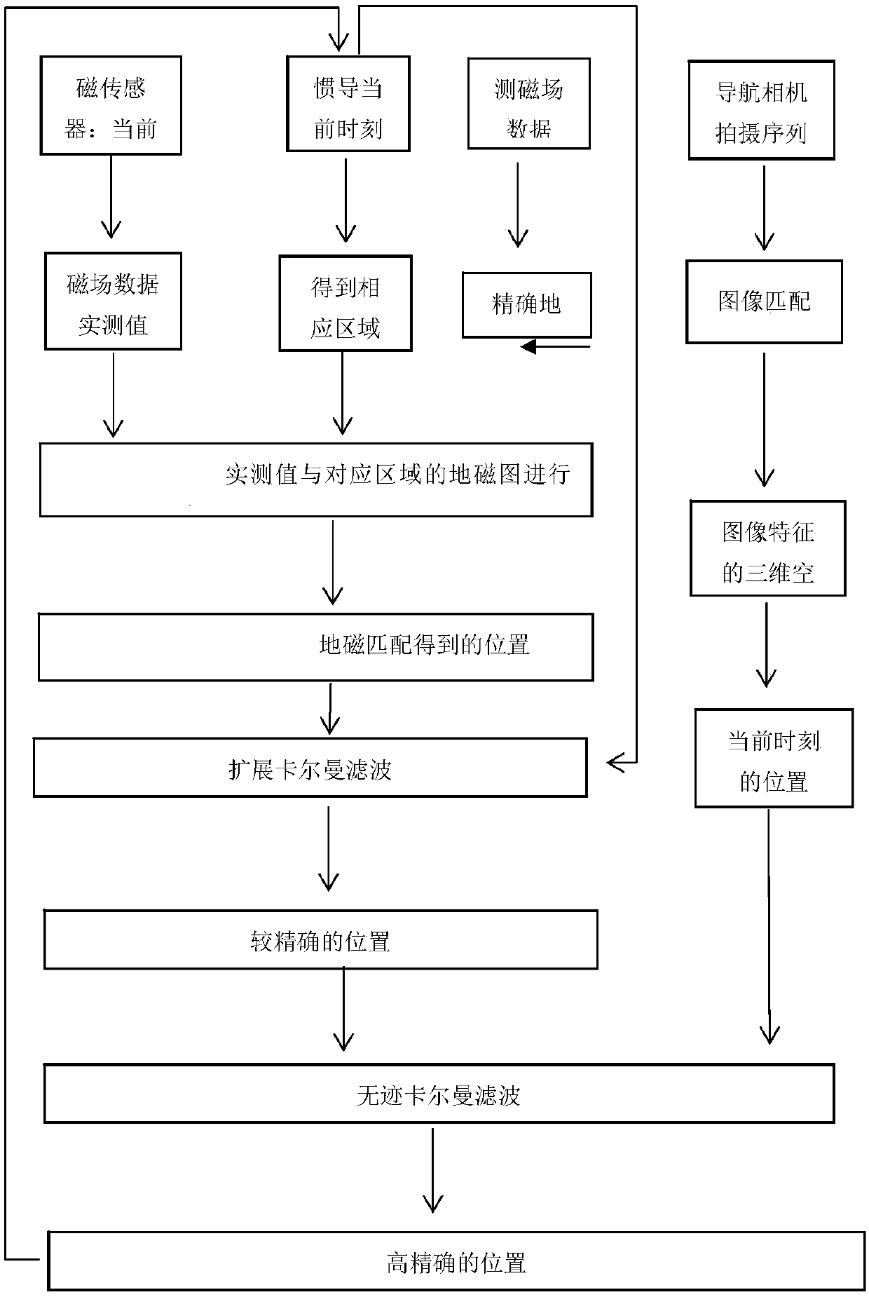
[0114] Such as figure 1 As shown, a complex area inspection robot positioning, navigation and timing method without GPS, the steps are as follows:

[0115] S1, constructing an accurate geomagnetic map;

[0116] Specifically: S1.1, the geomagnetic sensor carried by the inspection robot performs geomagnetic detection in the area to be inspected, and stores the obtained geomagnetic feature quantity;

[0117] S1.2, performing grid division on the area to be inspected to obtain a grid map;

[0118] S1.3, construct a local geomagnetic map based on Kriging interpolation for the obtained geomagnetic feature quantity, and match it with the grid map to obtain an accurate geomagnetic map;

[0119] The construction of the local geomagnetic map is based on the optimal interpolation method of spatial autocovariance. The three main components of the local geomagnetic field, the earth's main magnetic field, the geomagnetic anomaly field, and the disturbance magnetic field, have a one-to-one...


PUM


Abstract

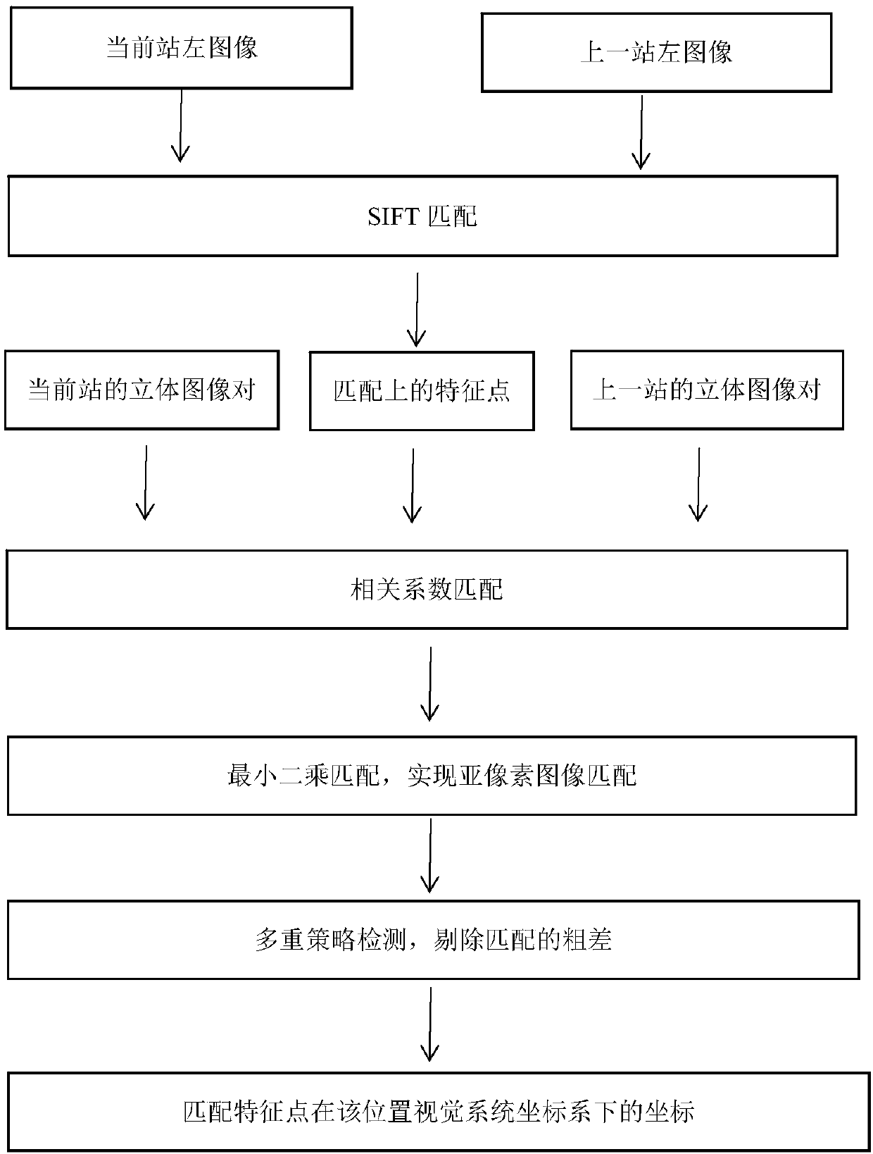
The invention discloses a complex area tour robot positioning, navigation and time service method under non GPS condition. The method comprises the following steps: establishing a fine magnetic map ofa tour area in advance, using an INS (inertial navigation system) for track conjecture, giving the current position of a robot, measuring the terrestrial magnetism characteristic quantity of a magnetic field at the current position measured by a carried terrestrial magnetism sensor, finding the terrestrial magnetism data characteristic quantity of a corresponding area in the fine magnetic map, coupling the terrestrial magnetism data characteristic quantity with the terrestrial magnetism data characteristic quantity measured at the current position to obtain the position given by the terrestrial magnetism coupled navigation, and using an expansion Kalman filter for fusing the state processes of the inertial navigation system and the terrestrial magnetism coupled navigation to obtain the accurate position information. The image capture is carried out by the visual sensor carried by a robot, the collected image is coupled, the position and attitude of the tour robot can be obtained, theunscented Kalman filter is used for fusing the state processes of two accurate positions, and the accurate and trusted position information is obtained.

Description

technical field [0001] The invention belongs to the field of positioning and navigation of mobile robots, and in particular relates to a positioning, navigation and timing method for patrolling robots in complex areas without GPS. Under the PNT (autonomous positioning, navigation and timing) method. Background technique [0002] At present, it is most widely used in positioning and navigation technology, and the most mature navigation method is the combination of INS inertial navigation and GPS satellite navigation. GPS satellite navigation has the advantages of being global, all-weather, and long-term accurate positioning, but its signal output is discontinuous and susceptible to interference and occlusion. When it is under trees or high-rise buildings, the signal quality will deteriorate, and the positioning will be inaccurate or unable to obtain positioning information. . INS inertial navigation system is an autonomous navigation method with strong concealment and anti-...

Claims


Application Information

Patent Timeline
IPC IPC(8): G01C21/20G01C21/16G01C21/08
CPCG01C21/005G01C21/08G01C21/165G01C21/20
Inventor 蔡磊张福深徐涛雷进辉杨献峰李国厚
Owner HENAN INST OF SCI & TECH
Learn More