
A UAV enhanced positioning method and system integrating GNSS and UWB

A technology that enhances positioning and unmanned aerial vehicles, applied in satellite radio beacon positioning systems, radio wave measurement systems, instruments, etc., can solve the problems of difficult positioning and navigation operations of unmanned aerial vehicles, and achieve the effect of convenient use

Active Publication Date: 2022-04-26
SHENZHEN UNIV
View PDF6 Cites 0 Cited by
  • Summary
  • Abstract
  • Description
  • Claims
  • Application Information

AI Technical Summary

Problems solved by technology

[0005] The technical problem to be solved by the present invention is to provide a UAV enhanced positioning method and system that integrates GNSS and UWB in view of the above-mentioned defects of the prior art, aiming at solving the problem that UAVs in the prior art are difficult to carry out in complex environments. The problem of precise positioning and navigation operations

Method used


Image

  • A UAV enhanced positioning method and system integrating GNSS and UWB
  • A UAV enhanced positioning method and system integrating GNSS and UWB
  • A UAV enhanced positioning method and system integrating GNSS and UWB

Examples


Embodiment Construction

[0043] In order to make the object, technical solution and advantages of the present invention clearer and clearer, the present invention will be further described in detail below with reference to the accompanying drawings and examples. It should be understood that the specific embodiments described here are only used to explain the present invention, not to limit the present invention.

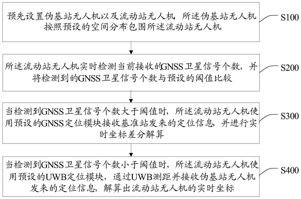
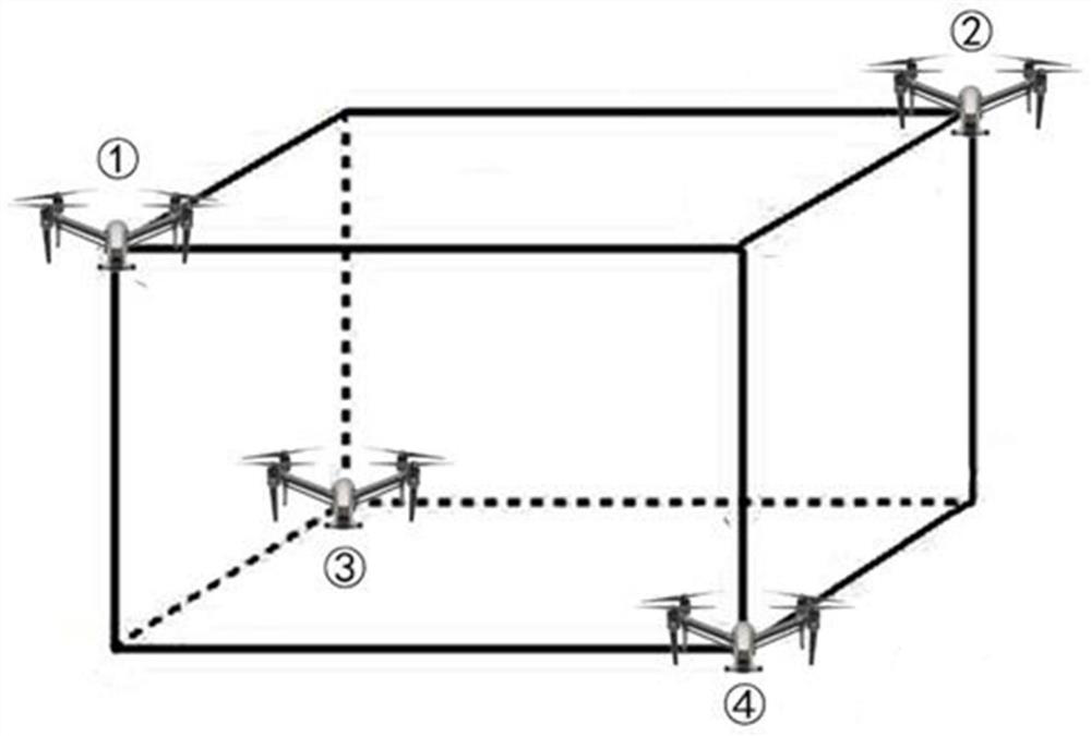
[0044] In the prior art, when the UAV is performing navigation operations outdoors, satellite signals are easily blocked by buildings, resulting in insufficient number of received GNSS observation satellites, making it impossible for the UAV to perform positioning. In order to solve the above problems, the present invention provides a UAV enhanced positioning method that integrates GNSS and UWB, such as figure 1 as shown, figure 1 It is a flow chart of a preferred embodiment of the UAV enhanced positioning method fused with GNSS and UWB of the present invention. The unmanned aerial vehicle...


PUM


Abstract

The invention discloses an enhanced positioning method and system for unmanned aerial vehicles integrating GNSS and UWB. The method includes: presetting a pseudo base station unmanned aerial vehicle and a rover unmanned aerial vehicle; the rover station unmanned aerial vehicle detects the current number of GNSS satellite signals, Compare the number of GNSS satellite signals with the threshold; when the number of satellite signals is greater than the threshold, the rover UAV uses the GNSS positioning module to receive the positioning information sent by the base station, and performs real-time coordinate difference decomposition; when the number of satellite signals is greater than the threshold When the number is less than the threshold, the rover UAV uses the UWB positioning module to measure the distance through UWB and receive the positioning information sent by the pseudo-base UAV to solve the real-time coordinates. The invention integrates the two positioning technologies of GNSS and UWB to realize the positioning of the drone in a complex environment. When the satellite signal is affected, the drone automatically uses the UWB for positioning, which overcomes the interference of the satellite signal to the positioning of the drone. Navigation effects.

Description

technical field [0001] The invention relates to the technical field of outdoor positioning, in particular to a UAV enhanced positioning method and system that integrates GNSS and UWB. Background technique [0002] Currently, GNSS (Global Navigation Satellite System, Global Navigation Satellite System) and UWB (Ultra-Wideband, ultra-wideband) are widely used in the field of positioning technology. [0003] UAVs can use GNSS to obtain high-precision positioning and navigation results in a good outdoor observation environment, but satellite signals are easily blocked by buildings, resulting in insufficient number of observation satellites received, making it impossible for UAVs to operate in such a complex environment. It is inconvenient for users to carry out related positioning and navigation operations in the environment. [0004] Therefore, the prior art still needs to be improved and developed. Contents of the invention [0005] The technical problem to be solved by th...

Claims


Application Information

Patent Timeline
Patent Type & Authority Patents(China)
IPC IPC(8): G01S19/48
CPCG01S19/48
Inventor 朱家松林伟东刘炎炎
Owner SHENZHEN UNIV
Learn More