Indoor 3D map matching method for pedestrian

A matching method and three-dimensional map technology, applied in measuring devices, instruments, surveying and mapping and navigation, etc., to achieve high algorithm accuracy, simplify complexity, and improve accuracy

Active Publication Date: 2018-08-21
BEIJING UNIV OF TECH
View PDF6 Cites 8 Cited by
  • Summary
  • Abstract
  • Description
  • Claims
  • Application Information

AI Technical Summary

Problems solved by technology

[0006] Aiming at the divergence problem caused by the navigation position of pedestrians wearing MEMS-INS sensors under indoor environmental conditions, the present invention provides a 3D map matching method for indoor pedestrian navigation

Method used


Image

  • Indoor 3D map matching method for pedestrian
  • Indoor 3D map matching method for pedestrian
  • Indoor 3D map matching method for pedestrian

Examples


Embodiment Construction

[0041] The present invention will be described in further detail below in conjunction with the accompanying drawings.

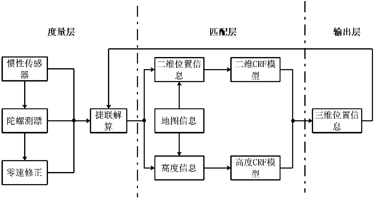
[0042] The frame structure of the method involved in the present invention is as figure 1 shown, including the following steps:

[0043] Step 1: Data collection, preliminary calculation of the 3D position and heading of indoor pedestrians.

[0044] In step 1.1, pedestrians wear MEMS-INS sensors to collect pedestrian movement data. The way pedestrians wear sensors is as follows: figure 2 shown. Pedestrian motion data includes: three-axis acceleration data and three-axis gyro data.

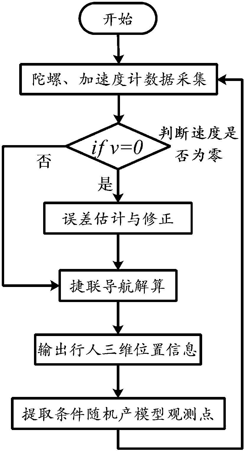
[0045] In step 1.2, the strapdown calculation algorithm is used to solve the three-dimensional position and heading information of the collected pedestrian motion data. The system flow chart of the inertial navigation solution is as follows image 3 shown.

[0046] Based on physics, under the condition that the sampling interval is very short, the velocity-position relationsh...


PUM


Abstract

The invention discloses an indoor 3D map matching method for a pedestrian and belongs to the technical field of indoor pedestrian positioning. An MEMS-INS (micro-electro-mechanical system-inertial navigation system) sensor tied on the foot surface of the pedestrian is used for acquiring indoor movement information of the pedestrian and calculating the speed, position and navigation direction of the pedestrian, an indoor structure is analyzed, state points are created, and a CFR (conditional random field) model is established according to navigation output position information and state point position information. Horizontal 2D position information of the indoor pedestrian is extracted according to a fixed-length walking distance, pedestrian height information is extracted at the zero-speedmoment, an observation point of the CFR model is acquired, and the 2D position of the indoor pedestrian and the sampling moment of height information are recorded respectively. An indoor electronic map is established, state points are created according to indoor structure information, and coordinates of the state points are stored. 3D positioning of the pedestrian can be realized and the algorithm accuracy is high; with the adoption of a method for matching the 2D position and the height information separately, the algorithm complexity is simplified; 2D position and the height information arefused with the approach moment, and the map matching accuracy is improved.

Description

technical field [0001] The invention belongs to the technical field of indoor pedestrian positioning, and relates to a pedestrian inertial navigation system (Inertial Navigation System, INS) synchronous positioning and matching algorithm structure based on micro-electro-mechanical system (Micro-Electro-Mechanical System, MEMS) technology under known indoor environment conditions A 3D map matching method fused with location information. Background technique [0002] In recent years, with the emergence and development of logistics, smart wards, and new concept supermarkets, indoor navigation has attracted extensive attention from academia and engineering. The integration and miniaturization of MEMS-INS make it a leading technology in the field of navigation. [0003] However, the inertial device error will accumulate over time. If the inertial device error is not effectively corrected, the pedestrian's position trajectory will eventually diverge. In order to solve the proble...

Claims


Application Information

Patent Timeline
Patent Type & Authority Applications(China)
IPC IPC(8): G01C21/30G01C21/34
CPCG01C21/30G01C21/3446
Inventor 任明荣郭红雨王普韩红桂
Owner BEIJING UNIV OF TECH
Why Eureka
Try Eureka