
Composite navigation system for intelligent patrol unmanned aerial vehicle

A composite navigation and unmanned aerial vehicle technology, applied in the field of small unmanned aerial vehicles, can solve the problems of lack of reliability and autonomy, self-adaptive adjustment of navigation system navigation accuracy, and inability to satisfy autonomous navigation at the same time, so as to improve reliability and The effect of autonomy and guaranteed precision

Active Publication Date: 2018-08-07
江苏中科智能科学技术应用研究院 +1
View PDF5 Cites 34 Cited by
  • Summary
  • Abstract
  • Description
  • Claims
  • Application Information

AI Technical Summary

Problems solved by technology

However, the current integrated navigation system does not have reliability and autonomy, that is, it cannot meet the requirements of autonomous navigation in indoor without GPS signals and outdoor unknown environments and complex conditions, and cannot adaptively adjust the navigation system in different environments to ensure the accuracy of navigation.

Method used


Image

  • Composite navigation system for intelligent patrol unmanned aerial vehicle
  • Composite navigation system for intelligent patrol unmanned aerial vehicle
  • Composite navigation system for intelligent patrol unmanned aerial vehicle

Examples


Embodiment Construction

[0028] The following description and drawings illustrate specific embodiments of the invention sufficiently to enable those skilled in the art to practice them.

[0029] Other embodiments may incorporate structural, logical, electrical, process, and other changes. The examples merely represent possible variations.

[0030] Individual components and functions are optional unless explicitly required, and the order of operations may vary.

[0031] Portions and features of some embodiments may be included in or substituted for those of other embodiments.

[0032] The scope of embodiments of the present invention includes the full scope of the claims, and all available equivalents of the claims.

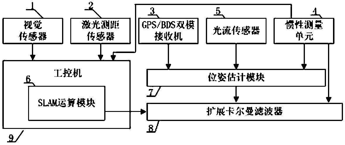
[0033] Such as figure 1 As shown, in some illustrative embodiments, a composite navigation system for intelligent patrol drones is provided, which is suitable for navigation in unknown and complex environments.

[0034] The invention uses GPS / BDS dual-mode receiver, inertial measureme...


PUM


Abstract

The invention provides a composite navigation system for an intelligent patrol unmanned aerial vehicle. The composite navigation system comprises a visual sensor, a laser distance measuring sensor, aGPS / BDS (global positioning system / Beidou system) two-mode receiver, an inertia measuring unit, a light flow sensor, a SLAM (simultaneous localization and map building) operation module, a position attitude estimating module and an expansion Kalman filter. The composite navigation system has the advantages that the data of different sensors is obtained according to the different environments of the unmanned aerial vehicle; after integrating by the expansion Kalman filter, the complete three-dimensional position attitude information of the unmanned aerial vehicle is outputted, so as to ensure the navigation precision; the reliability and autonomy of the navigation system are improved, and the composite navigation system is suitable for realizing the autonomous navigation of the unmanned aerial vehicle in unknown and complicated environments.

Description

technical field [0001] The invention belongs to the technical field of small unmanned aerial vehicles, and in particular relates to a composite navigation system for intelligent patrol unmanned aerial vehicles. Background technique [0002] In the field of UAV navigation, there are different advantages and disadvantages of a single navigation technology. [0003] The advantage of inertial navigation is that it is independent and not easily affected by the external environment. It can work around the clock and the frequency is updated quickly. The disadvantage is that errors will accumulate over time and the accuracy will be affected. [0004] The advantage of satellite navigation is that it can work around the clock and has no cumulative error. The disadvantage is that it is easily interfered, the update frequency is slow, and it cannot be positioned in an environment where satellite signals are blocked. [0005] The advantage of terrain-assisted navigation is that there is...

Claims


Application Information

Patent Timeline
Patent Type & Authority Applications(China)
IPC IPC(8): G01C21/00G01C21/16G01S19/48G01S19/49
CPCG01C21/00G01C21/165G01S19/48G01S19/49
Inventor 杜浩王伟肖冉徐朝文
Owner 江苏中科智能科学技术应用研究院
Learn More